FAA INFORMATION EFFECTIVE 09 JULY 2026
Location
| FAA Identifier: | MLI |
| Lat/Long: | 41-26-53.5530N 090-30-27.9720W
41-26.892550N 090-30.466200W
41.4482092,-90.5077700
(estimated) |
| Elevation: | 589.6 ft. / 179.7 m (surveyed) |
| Variation: | 01E (1985) |
| From city: | 3 miles S of MOLINE, IL |
| Time zone: | UTC -5 (UTC -6 during Standard Time) |
| Zip code: | 61264 |
Airport Operations
| Airport use: | Open to the public |
| Activation date: | 04/1940 |
| Control tower: | yes |
| ARTCC: | CHICAGO CENTER |
| FSS: | KANKAKEE FLIGHT SERVICE STATION |
| NOTAMs facility: | MLI (NOTAM-D service available) |
| Attendance: | CONTINUOUS |
| Wind indicator: | lighted |
| Segmented circle: | yes |
| Lights: | WHEN ATCT CLSD ACTVT AND INCR INTS RWY & TWY LIGHTING, MALSR RWY 9 & RWY 27; REIL RWY 13 & RWY 31 - CTAF. |
| Beacon: | white-green (lighted land airport)
Operates sunset to sunrise. |
| Landing fee: | yes, LDG FEES FOR TSNT ACFT 12,500 LBS AND GTR. |
| Fire and rescue: | ARFF index B |
| Airline operations: | ARFF INDEX C AVBL ON REQ; 24 HR PPR CALL AMGR (309) 757-1739 |
| International operations: | customs landing rights airport |
Airport Communications
| CTAF: | 119.4 |
| UNICOM: | 122.95 |
| ATIS: | 121.2 |
| WX ASOS: | 121.2 (309-233-0742) |
| QUAD CITY GROUND: | 121.9 [0530-2230] |
| QUAD CITY TOWER: | 119.4 269.55 [0530-2230] |
| QUAD CITY APPROACH: | 125.95 ;NORTH OF ACTIVE RWY 133.275 ;SOUTH OF ACTIVE RWY 257.8 [0530-2230] |
| QUAD CITY DEPARTURE: | 125.95 ;NORTH OF ACTIVE RWY 133.275 ;SOUTH OF ACTIVE RWY 257.8 [0530-2230] |
| CLEARANCE DELIVERY: | 124.05 |
| CLASS C: | 125.95 ;NORTH OF ACTIVE RWY 133.275 ;SOUTH OF ACTIVE RWY 257.8 |
| EMERG: | 121.5 243.0 |
| IC: | 125.95 ;NORTH OF ACTIVE RWY |
| WX ASOS at DVN (10 nm N): | 120.175 (563-388-2154) |
- APCH/DEP SVC PRVDD BY CHICAGO ARTCC ON FREQS 118.75/377.05 (MOLINE RCAG) WHEN QUAD CITY APCH CLSD.
Nearby radio navigation aids
| VOR radial/distance | | VOR name | | Freq | | Var |
|---|
| MZVr033/9.6 | | MOLINE VOR/DME | | 114.40 | | 05E |
| CVAr180/15.7 | | DAVENPORT VORTAC | | 113.80 | | 04E |
Airport Services
| Fuel available: | 100LL JET-A
100LL:100LL SELF SERVE FUEL PUMP LCTD IN T-HNGR AREA AND OPEN 24 HRS A DAY. |
| Parking: | hangars and tiedowns |
| Airframe service: | MAJOR |
| Powerplant service: | MAJOR |
| Bottled oxygen: | HIGH/LOW |
| Bulk oxygen: | HIGH/LOW |
Runway Information
Runway 9/27
| Dimensions: | 10002 x 150 ft. / 3049 x 46 m |
| Surface: | concrete/grooved, in good condition |
| Weight bearing capacity: | | Single wheel: | 120.0 | | Double wheel: | 229.0 | | Double tandem: | 369.0 | | Dual double tandem: | 850.0 |
|
| Runway edge lights: | high intensity |
| RUNWAY 9 | | RUNWAY 27 |
| Latitude: | 41-26.951147N | | 41-26.916978N |
| Longitude: | 090-31.621322W | | 090-29.432758W |
| Elevation: | 577.6 ft. | | 573.8 ft. |
| Traffic pattern: | left | | left |
| Runway heading: | 090 magnetic, 091 true | | 270 magnetic, 271 true |
| Declared distances: | TORA:10002 TODA:10002 ASDA:10002 LDA:10002 | | TORA:10002 TODA:10002 ASDA:10002 LDA:10002 |
| Markings: | precision, in good condition | | precision, in good condition |
| Visual slope indicator: | 4-light PAPI on left (3.00 degrees glide path) | | 4-light PAPI on left (3.00 degrees glide path) |
| RVR equipment: | touchdown, rollout | | touchdown, rollout |
| Approach lights: | MALSR: 1,400 foot medium intensity approach lighting system with runway alignment indicator lights | | MALSR: 1,400 foot medium intensity approach lighting system with runway alignment indicator lights |
| Runway end identifier lights: | no | | no |
| Touchdown point: | yes, no lights | | yes, no lights |
| Instrument approach: | ILS/DME | | ILS/DME |
| Obstructions: | none | | 207 ft. tree, 8959 ft. from runway, 1743 ft. left of centerline, 42:1 slope to clear |
Runway 13/31
| Dimensions: | 7301 x 150 ft. / 2225 x 46 m |
| Surface: | asphalt/concrete/porous friction courses, in good condition |
| Weight bearing capacity: | | Single wheel: | 120.0 | | Double wheel: | 185.0 | | Double tandem: | 301.0 | | Dual double tandem: | 721.0 |
|
| Runway edge lights: | high intensity |
| RUNWAY 13 | | RUNWAY 31 |
| Latitude: | 41-27.298037N | | 41-26.568130N |
| Longitude: | 090-30.925968W | | 090-29.656343W |
| Elevation: | 584.7 ft. | | 580.9 ft. |
| Traffic pattern: | left | | left |
| Runway heading: | 126 magnetic, 127 true | | 306 magnetic, 307 true |
| Displaced threshold: | no | | 522 ft. |
| Declared distances: | TORA:7301 TODA:7301 ASDA:7032 LDA:7032 | | TORA:7301 TODA:7301 ASDA:6954 LDA:6432 |
| Markings: | nonprecision, in good condition | | nonprecision, in good condition |
| Visual slope indicator: | 4-light PAPI on left (3.00 degrees glide path) | | 4-light PAPI on left (3.00 degrees glide path) |
| Runway end identifier lights: | yes | | yes |
| Touchdown point: | yes, no lights | | yes, no lights |
| Obstructions: | 45 ft. tree, 1665 ft. from runway, 271 ft. right of centerline, 32:1 slope to clear | | 173 ft. tree, 5522 ft. from runway, 559 ft. left of centerline, 30:1 slope to clear
140 FT PWR POLE DIST 5836 FT; 415 FT R; 41:1 BASED ON DSPLCD THLD. |
Runway 5/23
| Dimensions: | 3514 x 150 ft. / 1071 x 46 m |
| Surface: | concrete/grooved, in good condition |
| Weight bearing capacity: | | Single wheel: | 92.0 | | Double wheel: | 114.0 | | Double tandem: | 193.0 |
|
| Runway edge lights: | medium intensity |
| RUNWAY 5 | | RUNWAY 23 |
| Latitude: | 41-26.499555N | | 41-26.880245N |
| Longitude: | 090-30.946420W | | 090-30.367267W |
| Elevation: | 578.1 ft. | | 583.3 ft. |
| Traffic pattern: | left | | left |
| Runway heading: | 048 magnetic, 049 true | | 228 magnetic, 229 true |
| Declared distances: | TORA:3514 TODA:3514 ASDA:3514 LDA:3514 | | TORA:3514 TODA:3514 ASDA:3514 LDA:3514 |
| Markings: | basic, in fair condition | | basic, in fair condition |
| Visual slope indicator: | 4-light PAPI on left (4.00 degrees glide path) | | 4-light PAPI on left (3.00 degrees glide path) |
| Runway end identifier lights: | no | | no |
| Touchdown point: | yes, no lights | | yes, no lights |
Airport Ownership and Management from official FAA records
| Ownership: | Publicly-owned |
| Owner: | METROPOLITAN AIRPORT AUTH
2200 GEORGE KIRK DR.; SUITE 100
MOLINE, IL 61265
Phone 309-757-1768 |
| Manager: | BENJAMIN LEISCHNER
2200 GEORGE KIRK DR.; SUITE 100
MOLINE, IL 61265
Phone 309-757-1768 |
Additional Remarks
| A39-05/23 | PCR VALUE: 350/R/C/W/T |
| A39-09/27 | PCR VALUE: 750/R/C/W/T |
| A39-13/31 | PCR VALUE: 590/R/C/W/T |
| - | BIRDS & MIGRATORY FOWL ON & INVOF ARPT. |
Instrument Procedures
NOTE: All procedures below are presented as PDF files. If you need a reader for these files, you should download the free Adobe Reader.NOT FOR NAVIGATION. Please procure official charts for flight.
FAA instrument procedures published for use from 09 July 2026 at 0901Z to 06 August 2026 at 0900Z.
IAPs - Instrument Approach Procedures |
|---|
| ILS OR LOC RWY 09 | |
download (299KB) |
| ILS OR LOC RWY 27 | |
download (268KB) |
| RNAV (GPS) RWY 09 | |
download (319KB) |
| RNAV (GPS) RWY 13 | |
download (297KB) |
| RNAV (GPS) RWY 27 | |
download (311KB) |
| RNAV (GPS) RWY 31 | |
download (291KB) |
| NOTE: Special Alternate Minimums apply | |
download (140KB) |
| NOTE: Special Take-Off Minimums/Departure Procedures apply | |
download (488KB) |
Other nearby airports with instrument procedures:
KDVN - Davenport Municipal Airport (10 nm N)
KCWI - Clinton Municipal Airport (24 nm N)
KEZI - Kewanee Municipal Airport (29 nm SE)
KMUT - Muscatine Municipal Airport (29 nm W)
KGBG - Harrel W Timmons Galesburg Regional Airport (31 nm S)
|
|

Road maps at:
MapQuest
Bing
Google
| Aerial photo |
|---|
WARNING: Photo may not be current or correct
 Photo courtesy of AirNav, LLC
Photo taken 11-Sep-2012
looking west.
Photo courtesy of AirNav, LLC
Photo taken 11-Sep-2012
looking west.
Do you have a better or more recent aerial photo of Quad Cities International Airport that you would like to share? If so, please send us your photo.
|
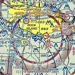
| Sectional chart |
|---|
|
CAUTION: Diagram may not be current
 Download PDF
of official airport diagram from the FAA
| Airport distance calculator |
|---|
|
|
| Sunrise and sunset |
|---|
|
Times for 15-Jul-2026
| | Local
(UTC-5) | | Zulu
(UTC) |
|---|
| Morning civil twilight | | 05:10 | | 10:10 |
| Sunrise | | 05:42 | | 10:42 |
| Sunset | | 20:33 | | 01:33 |
| Evening civil twilight | | 21:06 | | 02:06 |
|
| Current date and time |
|---|
| Zulu (UTC) | 15-Jul-2026 19:31:31 |
|---|
| Local (UTC-5) | 15-Jul-2026 14:31:31 |
|---|
|
| METAR |
|---|
| KMLI | 151852Z VRB04KT 10SM CLR 33/23 A3008 RMK AO2 SLP182 T03280228
|
KDVN
11nm N | 151852Z AUTO 31003KT 10SM FEW035 31/23 A3010 RMK AO2 SLP185 T03060228
|
|
| TAF |
|---|
| KMLI | 151721Z 1518/1618 33005KT P6SM SCT030 FM152300 VRB02KT P6SM FEW070
|
|
| NOTAMs |
|---|
NOTAMs are issued by the DoD/FAA and will open in a separate window not controlled by AirNav.
|
|


