FAA INFORMATION EFFECTIVE 25 DECEMBER 2025
Location
| FAA Identifier: | MLS |
| Lat/Long: | 46-25-36.7910N 105-53-17.6110W
46-25.613183N 105-53.293517W
46.4268864,-105.8882253
(estimated) |
| Elevation: | 2634.1 ft. / 802.9 m (surveyed) |
| Variation: | 09E (2020) |
| From city: | 2 miles NW of MILES CITY, MT |
| Time zone: | UTC -7 (UTC -6 during Daylight Saving Time) |
| Zip code: | 59301 |
Airport Operations
| Airport use: | Open to the public |
| Activation date: | 04/1940 |
| Control tower: | no |
| ARTCC: | SALT LAKE CITY CENTER |
| FSS: | GREAT FALLS FLIGHT SERVICE STATION |
| NOTAMs facility: | MLS (NOTAM-D service available) |
| Attendance: | DAYLIGHT HOURS |
| Wind indicator: | lighted |
| Segmented circle: | yes |
| Lights: | ACTVT REIL RWY 04, 13, 22, & 31; PAPI RWY 04, 13, 22, & 31; MIRL RWY 04/22 & RWY 13/31 - CTAF. |
| Beacon: | white-green (lighted land airport)
Operates sunset to sunrise. |
Airport Communications
| CTAF/UNICOM: | 123.0 |
| WX ASOS: | 135.575 (406-232-1465) |
- COMMUNICATIONS PRVDD BY GREAT FALLS RADIO ON 122.2 (MILES CITY RCO).
- APCH/DEP CTL SVC PRVDD BY SALT LAKE ARTCC (ZLC) ON 126.85/305.2 (MILES CITY RCAG).
Nearby radio navigation aids
| VOR radial/distance | | VOR name | | Freq | | Var |
|---|
| MLSr036/3.8 | | MILES CITY VOR/DME | | 112.10 | | 09E |
Airport Services
| Fuel available: | 100LL JET-A
100LL:AFT HR - 406-234-1296 OR 406-951-0955. |
| Parking: | hangars and tiedowns |
Runway Information
Runway 4/22
| Dimensions: | 5764 x 75 ft. / 1757 x 23 m |
| Surface: | asphalt, in good condition |
| Weight bearing capacity: | | Single wheel: | 24.0 | | Double wheel: | 24.0 |
|
| Runway edge lights: | medium intensity |
| RUNWAY 4 | | RUNWAY 22 |
| Latitude: | 46-25.172100N | | 46-25.756748N |
| Longitude: | 105-54.040110W | | 105-52.960778W |
| Elevation: | 2634.1 ft. | | 2625.2 ft. |
| Traffic pattern: | left | | left |
| Runway heading: | 043 magnetic, 052 true | | 223 magnetic, 232 true |
| Declared distances: | TORA:5764 TODA:5764 ASDA:5764 LDA:5764 | | TORA:5764 TODA:5764 ASDA:5764 LDA:5764 |
| Markings: | nonprecision, in good condition | | nonprecision, in good condition |
| Visual slope indicator: | 2-light PAPI on left (3.00 degrees glide path) | | 2-light PAPI on left (3.00 degrees glide path) |
| Runway end identifier lights: | yes | | yes |
| Touchdown point: | yes, no lights | | yes, no lights |
| Obstructions: | none | | 17 ft. road, 778 ft. from runway, 34:1 slope to clear |
Runway 13/31
| Dimensions: | 5624 x 100 ft. / 1714 x 30 m |
| Surface: | asphalt/grooved, in good condition |
| Weight bearing capacity: | | Single wheel: | 38.0 | | Double wheel: | 55.0 | | Double tandem: | 85.0 |
|
| Runway edge lights: | medium intensity |
| RUNWAY 13 | | RUNWAY 31 |
| Latitude: | 46-26.092050N | | 46-25.439143N |
| Longitude: | 105-53.555403W | | 105-52.607463W |
| Elevation: | 2630.0 ft. | | 2625.6 ft. |
| Traffic pattern: | left | | left |
| Runway heading: | 126 magnetic, 135 true | | 306 magnetic, 315 true |
| Declared distances: | TORA:5624 TODA:5624 ASDA:5624 LDA:5624 | | TORA:5624 TODA:5624 ASDA:5624 LDA:5624 |
| Markings: | nonprecision, in good condition | | nonprecision, in good condition |
| Visual slope indicator: | 2-light PAPI on left (3.00 degrees glide path) | | 2-light PAPI on left (3.00 degrees glide path) |
| Runway end identifier lights: | yes | | yes |
| Touchdown point: | yes, no lights | | yes, no lights |
Airport Ownership and Management from official FAA records
| Ownership: | Publicly-owned |
| Owner: | MILES CITY
PO BOX 910, 77 FRANK WILEY FIELD
MILES CITY, MT 59301
Phone 406-874-8602 |
| Manager: | JEFF LANGKAU
596 REYNOLDS RD
MILES CITY, MT 59301
Phone 406-951-0955 |
Additional Remarks
| - | TRNG ACT WI 15 MI. BIRDS INVOF ARPT. |
| - | COND UNMNT - AMGR. |
| - | FOR CD IF UNA TO CTC ON FSS FREQ, CTC SALT LAKE ARTCC AT 801-320-2568. |
Instrument Procedures
NOTE: All procedures below are presented as PDF files. If you need a reader for these files, you should download the free Adobe Reader.NOT FOR NAVIGATION. Please procure official charts for flight.
FAA instrument procedures published for use from 25 December 2025 at 0901z to 22 January 2026 at 0900z.
IAPs - Instrument Approach Procedures |
|---|
| RNAV (GPS) RWY 04 **CHANGED** | |
download (258KB) |
| RNAV (GPS) RWY 13 **CHANGED** | |
download (227KB) |
| RNAV (GPS) RWY 22 **CHANGED** | |
download (255KB) |
| RNAV (GPS) RWY 31 **CHANGED** | |
download (219KB) |
| VOR RWY 04 **CHANGED** | |
download (194KB) |
| VOR RWY 22 **CHANGED** | |
download (195KB) |
| NOTE: Special Alternate Minimums apply | |
download (186KB) |
| NOTE: Special Take-Off Minimums/Departure Procedures apply | |
download (537KB) |
Other nearby airports with instrument procedures:
1S3 - Tillitt Field Airport (32 nm W)
M46 - Colstrip Airport (48 nm SW)
4U6 - Circle Town County Airport (61 nm N)
KGDV - Dawson Community Airport (62 nm NE)
97M - Ekalaka Airport (65 nm SE)
|
|

Road maps at:
MapQuest
Bing
Google
| Aerial photo |
|---|
WARNING: Photo may not be current or correct
 Photo taken 26-Aug-2015
looking north.
Photo taken 26-Aug-2015
looking north.
Do you have a better or more recent aerial photo of Frank Wiley Field Airport that you would like to share? If so, please send us your photo.
|
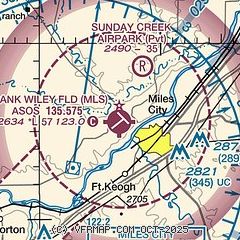
| Sectional chart |
|---|
|
| Airport distance calculator |
|---|
|
|
| Sunrise and sunset |
|---|
|
Times for 10-Jan-2026
| | Local
(UTC-7) | | Zulu
(UTC) |
|---|
| Morning civil twilight | | 07:12 | | 14:12 |
| Sunrise | | 07:47 | | 14:47 |
| Sunset | | 16:36 | | 23:36 |
| Evening civil twilight | | 17:10 | | 00:10 |
|
| Current date and time |
|---|
| Zulu (UTC) | 10-Jan-2026 09:02:45 |
|---|
| Local (UTC-7) | 10-Jan-2026 02:02:45 |
|---|
|
| METAR |
|---|
| KMLS | 100853Z AUTO 28013KT 10SM OVC100 01/M07 A3019 RMK AO2 SLP246 T00061067 53002
|
|
| TAF |
|---|
| KMLS | 100540Z 1006/1106 27009KT P6SM OVC090 FM101900 28014G25KT P6SM SCT100 BKN250
|
|
| NOTAMs |
|---|
NOTAMs are issued by the DoD/FAA and will open in a separate window not controlled by AirNav.
|
|


