FAA INFORMATION EFFECTIVE 30 OCTOBER 2025
Location
| FAA Identifier: | MNF |
| Lat/Long: | 36-59-34.2000N 091-42-52.1000W
36-59.570000N 091-42.868333W
36.9928333,-91.7144722
(estimated) |
| Elevation: | 1182 ft. / 360.3 m (surveyed) |
| Variation: | 00W (2015) |
| From city: | 1 mile SW of MOUNTAIN VIEW, MO |
| Time zone: | UTC -6 (UTC -5 during Daylight Saving Time) |
| Zip code: | 65548 |
Airport Operations
| Airport use: | Open to the public |
| Activation date: | 10/1965 |
| Control tower: | no |
| ARTCC: | KANSAS CITY CENTER |
| FSS: | COLUMBIA FLIGHT SERVICE STATION |
| NOTAMs facility: | COU (NOTAM-D service available) |
| Attendance: | 0800-1700
AFT HRS PHONE NBRS POSTED ON TERMINAL DOOR. |
| Wind indicator: | lighted |
| Segmented circle: | yes |
| Lights: | ACTVT MIRL RY 10/28 AND PAPI RY 28 - 122.8 |
| Beacon: | white-green (lighted land airport)
Operates sunset to sunrise. |
Airport Communications
| CTAF/UNICOM: | 122.8 |
| WX ASOS at UNO (11 nm SW): | 123.825 (417-257-1313) |
- APCH/DEP SVC PRVDD BY KANSAS CITY ARTCC ON FREQS 128.35/284.675 (RICHLAND RCAG).
Airport Services
| Fuel available: | 100LL
100LL:100LL AVLBL 24 HRS SELF SERVICE |
| Parking: | tiedowns |
| Airframe service: | NONE |
| Powerplant service: | NONE |
| Bottled oxygen: | NONE |
| Bulk oxygen: | NONE |
Runway Information
Runway 10/28
| Dimensions: | 5005 x 75 ft. / 1526 x 23 m |
| Surface: | asphalt, in fair condition |
| Runway edge lights: | medium intensity |
| Runway edge markings: | MARKINGS FADED |
| RUNWAY 10 | | RUNWAY 28 |
| Latitude: | 36-59.635538N | | 36-59.503262N |
| Longitude: | 091-43.375160W | | 091-42.360368W |
| Elevation: | 1182.0 ft. | | 1136.7 ft. |
| Traffic pattern: | left | | left |
| Runway heading: | 099 magnetic, 099 true | | 279 magnetic, 279 true |
| Displaced threshold: | 319 ft. | | no |
| Markings: | nonprecision, in poor condition | | nonprecision, in poor condition |
| Visual slope indicator: | | | 4-light PAPI on left (3.50 degrees glide path)
PAPI UNUSBL BYD 4 DEG LEFT OF CNTRLN. |
| Touchdown point: | yes, no lights | | yes, no lights |
| Obstructions: | 37 ft. pline, 600 ft. from runway, 197 ft. left of centerline, 10:1 slope to clear
8-12 FT SMALL TREES AND BRUSH 0-200 FT FROM RWY END 110 FT RIGHT AND 130 FT LEFT | | 45 ft. pole, 980 ft. from runway, 250 ft. right of centerline, 17:1 slope to clear |
Airport Ownership and Management from official FAA records
| Ownership: | Publicly-owned |
| Owner: | CITY OF MOUNTAIN VIEW
126 N. OAK, P.O. BOX 1090
MOUNTAIN VIEW, MO 65548
Phone 417- 934-2601 |
| Manager: | EDDIE OWENS
BOX 1090
MOUNTAIN VIEW, MO 65548
Phone (417) 934-2601
870-316-2241 (MOBILE) AFTER HOURS |
Additional Remarks
| - | WILDLIFE ON & INVOF ARPT. |
| - | FOR CD CTC KANSAS CITY ARTCC AT 913-254-8508. |
Instrument Procedures
NOTE: All procedures below are presented as PDF files. If you need a reader for these files, you should download the free Adobe Reader.NOT FOR NAVIGATION. Please procure official charts for flight.
FAA instrument procedures published for use from 30 October 2025 at 0901Z to 27 November 2025 at 0900Z.
IAPs - Instrument Approach Procedures |
|---|
| RNAV (GPS) RWY 10 | |
download (221KB) |
| RNAV (GPS) RWY 28 | |
download (244KB) |
| NOTE: Special Take-Off Minimums/Departure Procedures apply | |
download (426KB) |
Other nearby airports with instrument procedures:
KUNO - West Plains Regional Airport (11 nm SW)
KTVB - Cabool Memorial Airport (20 nm NW)
M48 - Houston Memorial Airport (24 nm NW)
1MO - Mountain Grove Memorial Airport (30 nm W)
K33 - Salem Memorial Airport (38 nm N)
|
|

Road maps at:
MapQuest
Bing
Google
| Aerial photo |
|---|
WARNING: Photo may not be current or correct
 Taken in March 2004
Do you have a better or more recent aerial photo of Mountain View Airport that you would like to share? If so, please send us your photo.
|
| Sectional chart |
|---|
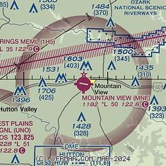
|
| Airport distance calculator |
|---|
|
|
| Sunrise and sunset |
|---|
|
Times for 18-Nov-2025
| | Local
(UTC-6) | | Zulu
(UTC) |
|---|
| Morning civil twilight | | 06:22 | | 12:22 |
| Sunrise | | 06:50 | | 12:50 |
| Sunset | | 16:55 | | 22:55 |
| Evening civil twilight | | 17:22 | | 23:22 |
|
| Current date and time |
|---|
| Zulu (UTC) | 18-Nov-2025 22:26:14 |
|---|
| Local (UTC-6) | 18-Nov-2025 16:26:14 |
|---|
|
| METAR |
|---|
KUNO
11nm SW | 182153Z AUTO 26013G27KT 10SM CLR 26/09 A2986 RMK AO2 PK WND 27030/2121 SLP103 T02560094
|
|
| TAF |
|---|
KTBN
47nm NW | 181400Z 1814/1920 20009KT 9999 FEW250 520006 QNH2979INS BECMG 1818/1819 25010G15KT 9999 SCT030 QNH2983INS BECMG 1821/1822 29009KT 9999 FEW028 QNH2983INS BECMG 1907/1908 35003KT 4000 BR BKN007 OVC014 QNH3001INS BECMG 1910/1911 02003KT 0800 FG OVC004 QNH3020INS BECMG 1917/1918 27003KT 8000 BR SCT008 BKN015 QNH3019INS TX23/1820Z TN11/1913Z
|
|
| NOTAMs |
|---|
NOTAMs are issued by the DoD/FAA and will open in a separate window not controlled by AirNav.
|
|

