FAA INFORMATION EFFECTIVE 14 MAY 2026
Location
| FAA Identifier: | MPG |
| Lat/Long: | 39-52-51.0000N 080-44-08.8000W
39-52.850000N 080-44.146667W
39.8808333,-80.7357778
(estimated) |
| Elevation: | 1214.6 ft. / 370.2 m (surveyed) |
| Variation: | 08W (2000) |
| From city: | 3 miles S of MOUNDSVILLE, WV |
| Time zone: | UTC -4 (UTC -5 during Standard Time) |
| Zip code: | 26041 |
Airport Operations
| Airport use: | Open to the public |
| Activation date: | 08/1975 |
| Control tower: | no |
| ARTCC: | CLEVELAND CENTER |
| FSS: | ELKINS FLIGHT SERVICE STATION [703-724-4288] |
| NOTAMs facility: | EKN (NOTAM-D service available) |
| Attendance: | 0830-DUSK
AFTER HRS ATNDT 304-312-1199 (MGR CELL). |
| Wind indicator: | lighted |
| Segmented circle: | yes |
| Lights: | ACTVT MIRL RWY 06/24 - CTAF. |
| Beacon: | white-green (lighted land airport)
ACTVT RTG BCN - CTAF. |
Airport Communications
| CTAF/UNICOM: | 122.7 |
| WX AWOS-3: | 119.05 (304-845-2959) |
| WX ASOS at HLG (18 nm N): | 127.375 (304-277-3504) |
- APCH/DEP SVC PRVDD BY CLEVELAND ARTCC ON FREQS 126.95/239.30 (BELMONT RCAG) OR CALL CLEVELAND ARTCC (ZOB) 440-774-0442.
Nearby radio navigation aids
| VOR radial/distance | | VOR name | | Freq | | Var |
|---|
| AIRr162/9.0 | | BELLAIRE VOR/DME | | 117.10 | | 07W |
| HLGr206/24.0 | | WHEELING VOR/DME | | 114.25 | | 07W |
| JPUr051/39.6 | | PARKERSBURG VOR/DME | | 114.45 | | 03W |
| AGCr242/39.8 | | ALLEGHENY VOR/DME | | 110.00 | | 09W |
| NDB name | | Hdg/Dist | | Freq | | Var | | ID |
|---|
| CADIZ | | 156/24.9 | | 239 | | 07W | | CFX | -.-. ..-. -..- |
Airport Services
| Fuel available: | 100LL
100LL:SELF SERVE FUEL AVBL 24/7. |
| Parking: | hangars and tiedowns |
| Airframe service: | MAJOR |
| Powerplant service: | MAJOR |
| Bottled oxygen: | NONE |
| Bulk oxygen: | NONE |
Runway Information
Runway 6/24
| Dimensions: | 3301 x 60 ft. / 1006 x 18 m |
| Surface: | asphalt, in fair condition |
| Weight bearing capacity: | |
| Runway edge lights: | medium intensity |
| RUNWAY 6 | | RUNWAY 24 |
| Latitude: | 39-52.680622N | | 39-53.017948N |
| Longitude: | 080-44.423310W | | 080-43.869872W |
| Elevation: | 1214.4 ft. | | 1194.6 ft. |
| Traffic pattern: | left | | left |
| Runway heading: | 060 magnetic, 052 true | | 240 magnetic, 232 true |
| Markings: | nonprecision, in good condition | | nonprecision, in good condition |
| Visual slope indicator: | 2-light PAPI on right (4.00 degrees glide path) | | 2-light PAPI on right (3.00 degrees glide path)
UNUSBL BYD 7 DEGS LEFT OF CNTRLN. |
| Touchdown point: | yes, no lights | | yes, no lights |
| Obstructions: | 213 ft. pline, 5525 ft. from runway, 25:1 slope to clear | | 128 ft. pline, 5200 ft. from runway, 34:1 slope to clear |
Airport Ownership and Management from official FAA records
| Ownership: | Publicly-owned |
| Owner: | MARSHALL CO COMSN
COUNTY COURT HOUSE, 600 SEVENTH STREET,
MOUNDSVILLE, WV 26041
Phone 304-845-0482 |
| Manager: | SUSAN BOARD
80 AIRPORT LANE
MOUNDSVILLE, WV 26041
Phone 304-845-0200 |
Additional Remarks
| - | DEER & BIRDS ON & INVOF ARPT. |
| - | RWY 06/24 SLOPES UP 0.6% FROM SOUTH TO NORTH. |
| - | RWY SAFETY AREA BOTH ENDS HAVE 100 FT DROP-OFFS 200 FT FM THR 0B. |
| - | RWY 24, DUE TO TERRAIN, WINDS MAY BE TURBULENT ON APCH. |
| - | FOR CD CTC CLEVELAND ARTCC AT 440-774-0226. |
| - | TREES IN CLOSE VCNTY OF AWOS & WINDSOCK MAY CAUSE ERRONEOUS READINGS. |
Instrument Procedures
NOTE: All procedures below are presented as PDF files. If you need a reader for these files, you should download the free Adobe Reader.NOT FOR NAVIGATION. Please procure official charts for flight.
FAA instrument procedures published for use from 14 May 2026 at 0901Z to 11 June 2026 at 0900Z.
IAPs - Instrument Approach Procedures |
|---|
| RNAV (GPS) RWY 06 **CHANGED** | |
download (213KB) |
| RNAV (GPS) RWY 24 **CHANGED** | |
download (174KB) |
| NOTE: Special Take-Off Minimums/Departure Procedures apply | |
download |
Other nearby airports with instrument procedures:
2P7 - Alderman Airport (15 nm NW)
4G5 - Monroe County Airport (18 nm W)
KHLG - Wheeling Ohio County Airport (18 nm N)
6G5 - Barnesville/Bradfield Airport (22 nm W)
8G6 - Harrison County Airport (25 nm NW)
|
|

Road maps at:
MapQuest
Bing
Google
| Aerial photo |
|---|
WARNING: Photo may not be current or correct

Do you have a better or more recent aerial photo of Marshall County Airport that you would like to share? If so, please send us your photo.
|
| Sectional chart |
|---|
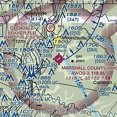
|
| Airport distance calculator |
|---|
|
|
| Sunrise and sunset |
|---|
|
Times for 17-May-2026
| | Local
(UTC-4) | | Zulu
(UTC) |
|---|
| Morning civil twilight | | 05:36 | | 09:36 |
| Sunrise | | 06:07 | | 10:07 |
| Sunset | | 20:32 | | 00:32 |
| Evening civil twilight | | 21:02 | | 01:02 |
|
| Current date and time |
|---|
| Zulu (UTC) | 17-May-2026 18:29:20 |
|---|
| Local (UTC-4) | 17-May-2026 14:29:20 |
|---|
|
| METAR |
|---|
KHLG
18nm N | 171753Z 20011KT 10SM CLR 24/17 A3013 RMK AO2 SLP198 T02440172 10244 20178 58007
|
KAFJ
26nm NE | 171756Z AUTO 21010G14KT 10SM 25/17 A3016 RMK AO2 SLP207 T02500172 10267 20161 58006 $
|
|
| TAF |
|---|
KHLG
18nm N | 171720Z 1718/1818 23009KT P6SM SCT040 FM180000 19003KT P6SM SCT250 FM181700 22010G20KT P6SM FEW250
|
|
| NOTAMs |
|---|
NOTAMs are issued by the DoD/FAA and will open in a separate window not controlled by AirNav.
|
|

