FAA INFORMATION EFFECTIVE 09 JULY 2026
Location
| FAA Identifier: | MPV |
| Lat/Long: | 44-12-12.5610N 072-33-43.5470W
44-12.209350N 072-33.725783W
44.2034892,-72.5620964
(estimated) |
| Elevation: | 1165.6 ft. / 355.3 m (surveyed) |
| Variation: | 16W (1995) |
| From city: | 3 miles W of central business district of the associated city |
| Time zone: | UTC -4 (UTC -5 during Standard Time) |
| Zip code: | 05641 |
Airport Operations
| Airport use: | Open to the public |
| Activation date: | 08/1937 |
| Control tower: | no |
| ARTCC: | BOSTON CENTER |
| FSS: | BURLINGTON FLIGHT SERVICE STATION |
| NOTAMs facility: | MPV (NOTAM-D service available) |
| Attendance: | 0800-1700 |
| Wind indicator: | yes |
| Segmented circle: | yes |
| Lights: | ACTVT MALSR RWY 17; MIRL RWY 17/35 - CTAF. |
| Beacon: | white-green (lighted land airport)
Operates sunset to sunrise. |
Airport Communications
| CTAF/UNICOM: | 122.8 |
| WX ASOS: | 132.675 (802-229-2037) |
| WX ASOS at MVL (20 nm N): | 135.625 (802-888-7934) |
- UNICOM BASE STN NOT MANNED CONSLY.
- APCH/DEP SVC PRVDD BY BOSTON ARTCC ON FREQS 135.7/282.2 (MONTPELIER RCAG).
Nearby radio navigation aids
| VOR radial/distance | | VOR name | | Freq | | Var |
|---|
| MPVr342/8.6 | | MONTPELIER VOR/DME | | 116.90 | | 16W |
| BTVr129/29.1 | | BURLINGTON VOR/DME | | 117.50 | | 15W |
| NDB name | | Hdg/Dist | | Freq | | Var | | ID |
|---|
| HANOVER | | 346/34.4 | | 276 | | 15W | | LAH | .-.. .- .... |
| SMUTO | | 045/34.4 | | 221 | | 15W | | DYO | -.. -.-- --- |
| MAHN | | 273/38.8 | | 386 | | 17W | | GMA | --. -- .- |
Airport Services
| Fuel available: | 100LL JET-A+ |
| Parking: | tiedowns |
| Airframe service: | MAJOR |
| Powerplant service: | MAJOR |
| Bottled oxygen: | NONE |
| Bulk oxygen: | NONE |
Runway Information
Runway 17/35
| Dimensions: | 5000 x 100 ft. / 1524 x 30 m |
| Surface: | asphalt, in good condition |
| Weight bearing capacity: | | Single wheel: | 31.0 | | Double wheel: | 70.0 |
|
| Runway edge lights: | medium intensity |
| RUNWAY 17 | | RUNWAY 35 |
| Latitude: | 44-12.397022N | | 44-11.672663N |
| Longitude: | 072-34.066883W | | 072-33.524263W |
| Elevation: | 1091.5 ft. | | 1165.6 ft. |
| Traffic pattern: | left | | left |
| Runway heading: | 168 magnetic, 152 true | | 348 magnetic, 332 true |
| Displaced threshold: | no | | 502 ft. |
| Markings: | precision, in good condition | | nonprecision, in good condition |
| Visual slope indicator: | 4-light PAPI on left (3.00 degrees glide path) | | |
| Approach lights: | MALSR: 1,400 foot medium intensity approach lighting system with runway alignment indicator lights | | |
| Runway end identifier lights: | no | | yes |
| Touchdown point: | yes, no lights | | yes, no lights |
| Instrument approach: | ILS/DME | | |
| Obstructions: | 35 ft. trees, 415 ft. from runway, 290 ft. left of centerline, 6:1 slope to clear
CLNC SLP 0:1 TO RWY 17 DTHR DUE TO 6 FT FENCE ON 6 FT HILL, 240 FT LEFT OF CNTRLN. | | 14 ft. ant, 262 ft. from runway, 197 ft. right of centerline, 4:1 slope to clear
160 FT TREE, 1200 FT FM DTHR, 140 FT L. OBSTN CLNC SLP 15:1. |
Runway 5/23
| Dimensions: | 3001 x 75 ft. / 915 x 23 m |
| Surface: | asphalt, in excellent condition |
| Weight bearing capacity: | | Single wheel: | 30.0 | | Double wheel: | 46.0 |
|
| Runway edge lights: | medium intensity |
| RUNWAY 5 | | RUNWAY 23 |
| Latitude: | 44-12.291640N | | 44-12.708633N |
| Longitude: | 072-33.793340W | | 072-33.425667W |
| Elevation: | 1115.5 ft. | | 1084.7 ft. |
| Traffic pattern: | left | | left |
| Runway heading: | 048 magnetic, 032 true | | 228 magnetic, 212 true |
| Markings: | basic, in good condition | | basic, in good condition |
| Runway end identifier lights: | no | | no |
| Touchdown point: | yes, no lights | | yes, no lights |
Airport Ownership and Management from official FAA records
| Ownership: | Publicly-owned |
| Owner: | STATE OF VERMONT
219 N MAIN ST
BARRE, VT 05641
Phone 802-279-7146 |
| Manager: | CHRIS BEITZEL
219 N MAIN ST
BARRE, VT 05641
Phone 802-272-7725 |
Additional Remarks
| - | FLD COND NOT MON WHEN UNATNDD. |
| - | COLD TEMPERATURE AIRPORT. ALTITUDE CORRECTION REQUIRED AT OR BELOW -19C. |
| - | FOR CD IF UNA TO CTC ON FSS FREQ, CTC BOSTON ARTCC AT 603-879-6859 . |
Instrument Procedures
NOTE: All procedures below are presented as PDF files. If you need a reader for these files, you should download the free Adobe Reader.NOT FOR NAVIGATION. Please procure official charts for flight.
FAA instrument procedures published for use from 09 July 2026 at 0901Z to 06 August 2026 at 0900Z.
IAPs - Instrument Approach Procedures |
|---|
| ILS OR LOC RWY 17 | |
download (314KB) |
| RNAV (GPS) RWY 17 | |
download (270KB) |
| RNAV (GPS) RWY 35 | |
download (243KB) |
| NOTE: Special Alternate Minimums apply | |
download (152KB) |
| NOTE: Special Take-Off Minimums/Departure Procedures apply | |
download (508KB) |
Other nearby airports with instrument procedures:
KMVL - Morrisville-Stowe State Airport (20 nm N)
5B9 - Dean Memorial Airport (25 nm E)
KBTV - Patrick Leahy Burlington International Airport (30 nm NW)
KCDA - Caledonia County Airport (32 nm NE)
KLEB - Lebanon Municipal Airport (36 nm S)
|
|

Road maps at:
MapQuest
Bing
Google
| Aerial photo |
|---|
WARNING: Photo may not be current or correct
 Photo by Pete Chaisson- Portland Flight Service
Photo taken 19-Aug-2014
looking southeast.
Photo by Pete Chaisson- Portland Flight Service
Photo taken 19-Aug-2014
looking southeast.
Do you have a better or more recent aerial photo of Edward F Knapp State Airport that you would like to share? If so, please send us your photo.
|
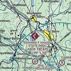
| Sectional chart |
|---|
|
| Airport distance calculator |
|---|
|
|
| Sunrise and sunset |
|---|
|
Times for 23-Jul-2026
| | Local
(UTC-4) | | Zulu
(UTC) |
|---|
| Morning civil twilight | | 04:55 | | 08:55 |
| Sunrise | | 05:29 | | 09:29 |
| Sunset | | 20:24 | | 00:24 |
| Evening civil twilight | | 20:58 | | 00:58 |
|
| Current date and time |
|---|
| Zulu (UTC) | 23-Jul-2026 21:03:13 |
|---|
| Local (UTC-4) | 23-Jul-2026 17:03:13 |
|---|
|
| METAR |
|---|
| KMPV | 232051Z AUTO 29007G16KT 10SM CLR 23/07 A3014 RMK AO2 SLP206 T02280072 53001
|
KMVL
18nm N | 232054Z AUTO VRB06G15KT 10SM SCT075 23/08 A3009 RMK AO2 SLP190 T02280078 53002
|
|
| TAF |
|---|
| KMPV | 231720Z 2318/2418 31012G20KT P6SM FEW050 FM232300 VRB04KT P6SM SKC FM241000 00000KT 5SM BR FEW002 FM241300 VRB03KT P6SM SKC
|
|
| NOTAMs |
|---|
NOTAMs are issued by the DoD/FAA and will open in a separate window not controlled by AirNav.
|
|

