FAA INFORMATION EFFECTIVE 09 JULY 2026
Location
| FAA Identifier: | MQB |
| Lat/Long: | 40-31-12.3000N 090-39-08.6000W
40-31.205000N 090-39.143333W
40.5200833,-90.6523889
(estimated) |
| Elevation: | 705.7 ft. / 215.1 m (surveyed) |
| Variation: | 01E (1990) |
| From city: | 3 miles N of MACOMB, IL |
| Time zone: | UTC -5 (UTC -6 during Standard Time) |
| Zip code: | 61455 |
Airport Operations
| Airport use: | Open to the public |
| Control tower: | no |
| ARTCC: | CHICAGO CENTER |
| FSS: | KANKAKEE FLIGHT SERVICE STATION |
| NOTAMs facility: | MQB (NOTAM-D service available) |
| Attendance: | SAT 0800-1200, ALL SUN UNATTENDED, ALL MON-FRI 0800-1700 |
| Wind indicator: | lighted |
| Segmented circle: | no |
| Lights: | HIRL RY 09/27 PRESET ON LOW INTST; TO INCR INTST & ACTVT REIL RY 09 & 27, AND TWY LGTS - CTAF. |
| Beacon: | white-green (lighted land airport)
Operates sunset to sunrise. |
Airport Communications
| CTAF/UNICOM: | 122.8 |
| WX AWOS-3: | 119.025 (309-837-4022) |
- APCH/DEP SVC PRVDD BY CHICAGO ARTCC ON FREQS 135.6/316.1 (BURLINGTON RCAG).
Nearby radio navigation aids
| VOR radial/distance | | VOR name | | Freq | | Var |
|---|
| BRLr129/17.4 | | BURLINGTON VOR/DME | | 115.55 | | 05E |
| NDB name | | Hdg/Dist | | Freq | | Var | | ID |
|---|
| MACOMB | | 271/4.2 | | 251 | | 01E | | JZY | .--- --.. -.-- |
Airport Services
| Fuel available: | 100LL JET-A |
| Parking: | hangars and tiedowns |
| Airframe service: | MAJOR |
| Powerplant service: | MAJOR |
| Bottled oxygen: | NONE |
| Bulk oxygen: | NONE |
Runway Information
Runway 9/27
| Dimensions: | 5100 x 100 ft. / 1554 x 30 m |
| Surface: | asphalt, in fair condition |
| Weight bearing capacity: | | Single wheel: | 18.0 | | Double wheel: | 21.0 |
|
| Runway edge lights: | high intensity |
| RUNWAY 9 | | RUNWAY 27 |
| Latitude: | 40-31.181883N | | 40-31.180603N |
| Longitude: | 090-39.662743W | | 090-38.562240W |
| Elevation: | 705.7 ft. | | 679.4 ft. |
| Traffic pattern: | left | | left |
| Runway heading: | 089 magnetic, 090 true | | 269 magnetic, 270 true |
| Markings: | nonprecision, in good condition | | nonprecision, in good condition |
| Visual slope indicator: | 4-light PAPI on left (3.00 degrees glide path)
PAPI UNUSBL BYD 8 DEGS RIGHT OF CNTRLN. | | 4-light PAPI on left (3.00 degrees glide path) |
| Runway end identifier lights: | yes | | yes |
| Touchdown point: | yes, no lights | | yes, no lights |
| Instrument approach: | | | LOCALIZER |
Runway 18/36
| Dimensions: | 3719 x 190 ft. / 1134 x 58 m
TURF WIDTH 200 FT SOUTH OF INTERSECTION WITH RY 09/27. |
| Surface: | turf, in good condition |
| Operational restrictions: | RY 18/36 SEASONAL, NOV 1 - MAY 1 CTC AMGR 309-833-3324. |
| RUNWAY 18 | | RUNWAY 36 |
| Latitude: | 40-31.542302N | | 40-30.929775N |
| Longitude: | 090-39.186633W | | 090-39.187833W |
| Elevation: | 691.3 ft. | | 681.6 ft. |
| Traffic pattern: | left | | left |
| Runway heading: | 179 magnetic, 180 true | | 359 magnetic, 000 true |
| Runway end identifier lights: | no | | no |
| Touchdown point: | yes, no lights | | yes, no lights |
Airport Ownership and Management from official FAA records
| Ownership: | Publicly-owned |
| Owner: | MACOMB ARPT AUTHORITY
16190 E 1300TH ST
MACOMB, IL 61455
Phone 309-833-3324 |
| Manager: | LEE COBB
16190 E 1300TH ST
MACOMB, IL 61455
Phone 309-833-3324 |
Additional Remarks
| - | FOR CD IF UNA TO CTC ON FSS FREQ, CTC CHICAGO ARTCC AT 630-906-8921. |
Instrument Procedures
NOTE: All procedures below are presented as PDF files. If you need a reader for these files, you should download the free Adobe Reader.NOT FOR NAVIGATION. Please procure official charts for flight.
FAA instrument procedures published for use from 09 July 2026 at 0901Z to 06 August 2026 at 0900Z.
IAPs - Instrument Approach Procedures |
|---|
| RNAV (GPS) RWY 09 | |
download (243KB) |
| RNAV (GPS) RWY 27 | |
download (245KB) |
| LOC RWY 27 | |
download (199KB) |
| NOTE: Special Alternate Minimums apply | |
download (140KB) |
| NOTE: Special Take-Off Minimums/Departure Procedures apply | |
download (504KB) |
Other nearby airports with instrument procedures:
C66 - Monmouth Municipal Airport (25 nm N)
KCTK - Ingersoll Airport (26 nm E)
KBRL - Southeast Iowa Regional Airport (27 nm NW)
KGBG - Harrel W Timmons Galesburg Regional Airport (27 nm N)
KFSW - Fort Madison Municipal Airport (32 nm W)
|
|

Road maps at:
MapQuest
Bing
Google
| Aerial photo |
|---|
WARNING: Photo may not be current or correct
 Photo taken 16-Aug-2006
Do you have a better or more recent aerial photo of Macomb Municipal Airport that you would like to share? If so, please send us your photo.
|
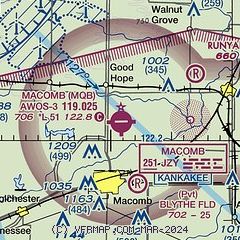
| Sectional chart |
|---|
|
| Airport distance calculator |
|---|
|
|
| Sunrise and sunset |
|---|
|
Times for 30-Jul-2026
| | Local
(UTC-5) | | Zulu
(UTC) |
|---|
| Morning civil twilight | | 05:28 | | 10:28 |
| Sunrise | | 05:59 | | 10:59 |
| Sunset | | 20:19 | | 01:19 |
| Evening civil twilight | | 20:50 | | 01:50 |
|
| Current date and time |
|---|
| Zulu (UTC) | 30-Jul-2026 08:58:47 |
|---|
| Local (UTC-5) | 30-Jul-2026 03:58:47 |
|---|
|
| METAR |
|---|
| KMQB | 300835Z AUTO 00000KT 10SM CLR 15/15 A3006 RMK AO2 T01480148
|
|
| TAF |
|---|
KBRL
26nm NW | 300520Z 3006/3106 VRB04KT P6SM SKC FM301600 14007KT P6SM SKC
|
|
| NOTAMs |
|---|
NOTAMs are issued by the DoD/FAA and will open in a separate window not controlled by AirNav.
|
|


