FAA INFORMATION EFFECTIVE 19 FEBRUARY 2026
Location
| FAA Identifier: | OMH |
| Lat/Long: | 38-14-49.9300N 078-02-44.2360W
38-14.832167N 078-02.737267W
38.2472028,-78.0456211
(estimated) |
| Elevation: | 464.4 ft. / 141.5 m (surveyed) |
| Variation: | 09W (1990) |
| From city: | 3 miles E of ORANGE, VA |
| Time zone: | UTC -5 (UTC -4 during Daylight Saving Time) |
| Zip code: | 22960 |
Airport Operations
| Airport use: | Open to the public |
| Activation date: | 11/1946 |
| Control tower: | no |
| ARTCC: | WASHINGTON CENTER |
| FSS: | LEESBURG FLIGHT SERVICE STATION |
| NOTAMs facility: | OMH (NOTAM-D service available) |
| Attendance: | 0800-1700
UNATDD FEDERAL HOL & EASTER. |
| Wind indicator: | lighted |
| Segmented circle: | yes |
| Lights: | ACTVT REIL RWY 08 & 26; PAPI RWY 08 & 26; MIRL RWY 08/26 - CTAF. |
| Beacon: | white-green (lighted land airport)
Operates sunset to sunrise. |
Airport Communications
| CTAF/UNICOM: | 122.8 |
| WX AWOS-3: | 118.075 (540-672-0505) |
| POTOMAC APPROACH: | 132.85 120.525 |
| POTOMAC DEPARTURE: | 132.85 120.525 |
| WX AWOS-3 at GVE (8 nm SW): | 120.225 (540-832-2095) |
| WX AWOS-3 at LKU (15 nm S): | 119.475 (540-967-1983) |
| WX AWOS-3 at CJR (19 nm NE): | 119.325 (540-727-0523) |
Nearby radio navigation aids
| VOR radial/distance | | VOR name | | Freq | | Var |
|---|
| GVEr026/14.9 | | GORDONSVILLE VORTAC | | 115.60 | | 06W |
| CSNr206/25.1 | | CASANOVA VORTAC | | 116.30 | | 06W |
| BRVr270/33.1 | | BROOKE VORTAC | | 114.50 | | 09W |
| LDNr174/37.2 | | LINDEN VORTAC | | 114.30 | | 06W |
| NDB name | | Hdg/Dist | | Freq | | Var | | ID |
|---|
| NAILR | | 218/14.1 | | 351 | | 10W | | MSQ | -- ... --.- |
| SHANNON | | 278/28.1 | | 237 | | 10W | | EZF | . --.. ..-. |
| CAVERNS | | 153/33.7 | | 245 | | 09W | | LUA | .-.. ..- .- |
Airport Services
| Fuel available: | 100LL JET-A+
100LL:100LL SELF SERVICE AFTER HOURS.
A+:JET-A+ SELF SERVICE AFTER HOURS. |
| Parking: | tiedowns |
| Airframe service: | NONE |
| Powerplant service: | NONE |
| Bottled oxygen: | NONE |
| Bulk oxygen: | NONE |
Runway Information
Runway 8/26
| Dimensions: | 3200 x 75 ft. / 975 x 23 m |
| Surface: | asphalt/aggregate friction seal coat, in good condition |
| Weight bearing capacity: | |
| Runway edge lights: | medium intensity |
| RUNWAY 8 | | RUNWAY 26 |
| Latitude: | 38-14.724085N | | 38-14.940225N |
| Longitude: | 078-03.042140W | | 078-02.432390W |
| Elevation: | 445.3 ft. | | 464.4 ft. |
| Traffic pattern: | left | | left |
| Runway heading: | 075 magnetic, 066 true | | 255 magnetic, 246 true |
| Markings: | nonprecision, in good condition | | nonprecision, in good condition |
| Visual slope indicator: | 2-light PAPI on left (4.00 degrees glide path) | | 2-light PAPI on left (4.00 degrees glide path) |
| Runway end identifier lights: | yes | | yes |
| Touchdown point: | yes, no lights | | yes, no lights |
| Obstructions: | 103 ft. tree, 2389 ft. from runway, 374 ft. left of centerline, 21:1 slope to clear | | 60 ft. pole, marked and lighted, 1185 ft. from runway, 381 ft. left of centerline, 16:1 slope to clear |
Airport Ownership and Management from official FAA records
| Ownership: | Publicly-owned |
| Owner: | ORANGE COUNTY
P O BOX 111
ORANGE, VA 22960
Phone 540-661-5400 |
| Manager: | PAUL J. WEBER
11275 AVIATION WAY
ORANGE, VA 22960
Phone 540-672-2158
MOBILE 540-406-1821 |
Additional Remarks
| - | FOR CD CTC POTOMAC APCH AT 866-640-4124. |
| - | PARACHUTE OPS. |
Instrument Procedures
NOTE: All procedures below are presented as PDF files. If you need a reader for these files, you should download the free Adobe Reader.NOT FOR NAVIGATION. Please procure official charts for flight.
FAA instrument procedures published for use from 19 February 2026 at 0901Z to 19 March 2026 at 0900Z.
IAPs - Instrument Approach Procedures |
|---|
| RNAV (GPS) RWY 08 | |
download (206KB) |
| RNAV (GPS) RWY 26 | |
download (210KB) |
| VOR/DME-A | |
download (195KB) |
| NOTE: Special Alternate Minimums apply | |
download |
| NOTE: Special Take-Off Minimums/Departure Procedures apply | |
download |
Other nearby airports with instrument procedures:
KGVE - Gordonsville Municipal Airport (8 nm SW)
KLKU - Louisa County Airport/Freeman Field (15 nm S)
KCJR - Culpeper Regional Airport (19 nm NE)
KCHO - Charlottesville-Albemarle Airport (20 nm W)
7W4 - Lake Anna Airport (22 nm SE)
|
|

Road maps at:
MapQuest
Bing
Google
| Aerial photo |
|---|
WARNING: Photo may not be current or correct
 Photo taken 11-Nov-2018
looking north-northeast.
Photo taken 11-Nov-2018
looking north-northeast.
Do you have a better or more recent aerial photo of Orange County Airport that you would like to share? If so, please send us your photo.
|
| Sectional chart |
|---|
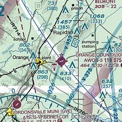
|
| Airport distance calculator |
|---|
|
|
| Sunrise and sunset |
|---|
|
Times for 28-Feb-2026
| | Local
(UTC-5) | | Zulu
(UTC) |
|---|
| Morning civil twilight | | 06:20 | | 11:20 |
| Sunrise | | 06:47 | | 11:47 |
| Sunset | | 18:03 | | 23:03 |
| Evening civil twilight | | 18:30 | | 23:30 |
|
| Current date and time |
|---|
| Zulu (UTC) | 01-Mar-2026 02:03:25 |
|---|
| Local (UTC-5) | 28-Feb-2026 21:03:25 |
|---|
|
| METAR |
|---|
| KOMH | 010155Z AUTO 00000KT 10SM CLR 08/03 A3002 RMK AO2
|
KGVE
8nm SW | 010155Z AUTO 00000KT 10SM CLR 07/04 A3002 RMK AO1 T00720042
|
KLKU
14nm S | 010155Z AUTO 20004KT 10SM CLR 08/05 A3003 RMK AO2 T00850054
|
KCJR
19nm NE | 010155Z AUTO 00000KT 10SM CLR 07/02 A3003 RMK AO2 T00660023
|
|
| TAF |
|---|
KCHO
20nm W | 281722Z 2818/0118 07003KT P6SM SKC FM282300 14003KT P6SM SKC FM010000 00000KT P6SM FEW070 FM011300 03003KT P6SM SCT045 FM011600 02005KT P6SM SCT035 FM011700 04007KT P6SM SCT029
|
|
| NOTAMs |
|---|
NOTAMs are issued by the DoD/FAA and will open in a separate window not controlled by AirNav.
|
|

