FAA INFORMATION EFFECTIVE 27 NOVEMBER 2025
Location
| FAA Identifier: | ORG |
| Lat/Long: | 30-04-06.4258N 093-48-14.4728W
30-04.107097N 093-48.241213W
30.0684516,-93.8040202
(estimated) |
| Elevation: | 13.2 ft. / 4.0 m (surveyed) |
| Variation: | 02E (2010) |
| From city: | 3 miles SW of ORANGE, TX |
| Time zone: | UTC -6 (UTC -5 during Daylight Saving Time) |
| Zip code: | 77630 |
Airport Operations
| Airport use: | Open to the public |
| Activation date: | 12/1946 |
| Control tower: | no |
| ARTCC: | HOUSTON CENTER |
| FSS: | MONTGOMERY COUNTY FLIGHT SERVICE STATION |
| NOTAMs facility: | ORG (NOTAM-D service available) |
| Attendance: | 0700-1700 |
| Wind indicator: | lighted |
| Segmented circle: | yes |
| Lights: | MIRL RWY 04/22 PRESET LOW INTST; TO INCR INTST & ACTVT REIL RWY 4 & 22 - CTAF. |
| Beacon: | white-green (lighted land airport)
Operates sunset to sunrise. |
Airport Communications
| CTAF/UNICOM: | 122.8 |
| WX AWOS-3: | 118.975 (409-670-9591) |
| HOUSTON APPROACH: | 121.3 |
| HOUSTON DEPARTURE: | 121.3 |
| WX ASOS at BPT (13 nm SW): | 126.3 (409-223-4011) |
Nearby radio navigation aids
| VOR radial/distance | | VOR name | | Freq | | Var |
|---|
| SBIr021/25.9 | | SABINE PASS VOR/DME | | 115.40 | | 07E |
| LCHr256/36.5 | | LAKE CHARLES VORTAC | | 113.40 | | 07E |
| NDB name | | Hdg/Dist | | Freq | | Var | | ID |
|---|
| GOODHUE | | 083/21.1 | | 368 | | 07E | | GDE | --. -.. . |
| SULPHUR | | 245/21.4 | | 278 | | 04E | | AUR | .- ..- .-. |
Airport Services
| Fuel available: | 100LL JET-A |
| Parking: | tiedowns |
| Airframe service: | MAJOR |
| Powerplant service: | MAJOR |
Runway Information
Runway 4/22
| Dimensions: | 5500 x 75 ft. / 1676 x 23 m |
| Surface: | asphalt, in good condition |
| Weight bearing capacity: | |
| Runway edge lights: | medium intensity |
| RUNWAY 4 | | RUNWAY 22 |
| Latitude: | 30-03.746817N | | 30-04.419290N |
| Longitude: | 093-48.475133W | | 093-47.774762W |
| Elevation: | 10.3 ft. | | 12.3 ft. |
| Traffic pattern: | left | | left |
| Runway heading: | 040 magnetic, 042 true | | 220 magnetic, 222 true |
| Markings: | nonprecision, in good condition | | nonprecision, in good condition |
| Visual slope indicator: | 2-light PAPI on left (3.00 degrees glide path) | | 2-light PAPI on left (3.00 degrees glide path) |
| Runway end identifier lights: | yes | | yes |
| Touchdown point: | yes, no lights | | yes, no lights |
| Obstructions: | 24 ft. trees, 375 ft. from runway, 270 ft. both sides of centerline, 7:1 slope to clear | | 41 ft. trees, 1030 ft. from runway, 380 ft. both sides of centerline, 20:1 slope to clear |
Runway 13/31
| Dimensions: | 3000 x 50 ft. / 914 x 15 m |
| Surface: | turf, in good condition
RWY NOT MNTND, RWY SFC ROUGH, DEEP RUTS, NOT SUITABLE FOR ACFT. |
| Operational restrictions: | RWY 13/31 CLSD INDEFLY. |
| RUNWAY 13 | | RUNWAY 31 |
| Latitude: | 30-04.332650N | | 30-03.969700N |
| Longitude: | 093-48.648450W | | 093-48.260283W |
| Elevation: | 10.0 ft. | | 10.0 ft. |
| Traffic pattern: | left | | left |
| Runway heading: | 135 magnetic, 137 true | | 315 magnetic, 317 true |
| Touchdown point: | yes, no lights | | yes, no lights |
| Obstructions: | 30 ft. tree, 50 ft. left of centerline | | 60 ft. trees, 800 ft. from runway, 13:1 slope to clear |
Airport Ownership and Management from official FAA records
| Ownership: | Publicly-owned |
| Owner: | ORANGE COUNTY
123 S. 6TH STREET
ORANGE, TX 77630
Phone (409) 882-7070 |
| Manager: | MISSY PILLSBURY
2640 S. HWY 87
ORANGE, TX 77630
Phone 409-882-7861 |
Additional Remarks
| - | TREES OBST PRI SFC RWY 13/31. |
| - | 3 FT OPEN DRAINAGE CULVERT AT THR, 31 FT BOTH SIDES. |
| - | FOR CD CTC HOUSTON APCH AT 281-443-5844 TO CNL IFR CALL 281-443-5888. |
Instrument Procedures
NOTE: All procedures below are presented as PDF files. If you need a reader for these files, you should download the free Adobe Reader.NOT FOR NAVIGATION. Please procure official charts for flight.
FAA instrument procedures published for use from 27 November 2025 at 0901Z to 25 December 2025 at 0900Z.
IAPs - Instrument Approach Procedures |
|---|
| RNAV (GPS) RWY 22 | |
download (231KB) |
| NOTE: Special Alternate Minimums apply | |
download (147KB) |
| NOTE: Special Take-Off Minimums/Departure Procedures apply | |
download (70KB) |
Other nearby airports with instrument procedures:
KBPT - Jack Brooks Regional Airport (13 nm SW)
KBMT - Beaumont Municipal Airport (21 nm W)
KUXL - Southland Field Airport (23 nm E)
5R8 - De Quincy Industrial Airpark (28 nm NE)
45R - Hawthorne Field Airport (28 nm NW)
|
|

Road maps at:
MapQuest
Bing
Google
| Aerial photo |
|---|
WARNING: Photo may not be current or correct

Do you have a better or more recent aerial photo of Orange County Airport that you would like to share? If so, please send us your photo.
|
| Sectional chart |
|---|
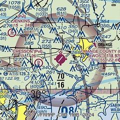
|
| Airport distance calculator |
|---|
|
|
| Sunrise and sunset |
|---|
|
Times for 10-Dec-2025
| | Local
(UTC-6) | | Zulu
(UTC) |
|---|
| Morning civil twilight | | 06:35 | | 12:35 |
| Sunrise | | 07:01 | | 13:01 |
| Sunset | | 17:15 | | 23:15 |
| Evening civil twilight | | 17:41 | | 23:41 |
|
| Current date and time |
|---|
| Zulu (UTC) | 10-Dec-2025 14:51:22 |
|---|
| Local (UTC-6) | 10-Dec-2025 08:51:22 |
|---|
|
| METAR |
|---|
| KORG | 101435Z AUTO 00000KT 10SM CLR 11/11 A3003 RMK AO2 T01120110 PWINO
|
KBPT
14nm SW | 101353Z 16003KT 10SM CLR 11/11 A2999 RMK AO2 SLP153 T01110111
|
|
| TAF |
|---|
KBPT
14nm SW | 101133Z 1012/1112 16004KT 5SM BR FEW250 TEMPO 1012/1014 1/2SM FG VV002 FM101400 22007KT P6SM SCT250 FM101800 29009G17KT P6SM SCT250 FM110000 35007KT P6SM SKC
|
|
| NOTAMs |
|---|
NOTAMs are issued by the DoD/FAA and will open in a separate window not controlled by AirNav.
|
|

