FAA INFORMATION EFFECTIVE 09 JULY 2026
Location
| FAA Identifier: | PBG |
| Lat/Long: | 44-39-03.4000N 073-28-05.3000W
44-39.056667N 073-28.088333W
44.6509444,-73.4681389
(estimated) |
| Elevation: | 234.2 ft. / 71.4 m (surveyed) |
| Variation: | 15W (1985) |
| From city: | 3 miles S of PLATTSBURGH, NY |
| Time zone: | UTC -4 (UTC -5 during Standard Time) |
| Zip code: | 12901 |
Airport Operations
| Airport use: | Open to the public |
| Control tower: | no |
| ARTCC: | BOSTON CENTER |
| FSS: | BURLINGTON FLIGHT SERVICE STATION |
| NOTAMs facility: | PBG (NOTAM-D service available) |
| Attendance: | 0530-2130 |
| Wind indicator: | lighted |
| Segmented circle: | yes |
| Lights: | ACTVT MALSR RWY 35; REIL RWY 17; HIRL RWY 17/35; TWY LGTS - CTAF. |
| Beacon: | white-green (lighted land airport)
Operates sunset to sunrise. |
| Landing fee: | yes, LDG FEES FOR ACFT OVER 12500 LBS MGLW; NO LDG FEE FOR GOVERNMENT ACFT. |
| Fire and rescue: | ARFF index B |
| Airline operations: | PPR 24 HRS FOR UNSKED ACR OPNS WITH MORE THAN 30 PSGR SEATS. INDEX E COVERAGE IS AVBL UPON REQ. 24 HRS PRIOR NOTICE RQRD. CALL AMGR AT 518-565-4008 OR 518-335-3735. |
| International operations: | US CUSTOMS USER FEE ARPT. |
Airport Communications
| CTAF/UNICOM: | 122.7 |
| WX ASOS: | 132.225 (518-957-5905) |
| BURLINGTON APPROACH: | 121.1 |
| BURLINGTON DEPARTURE: | 121.1 |
| CLEARANCE DELIVERY: | 121.85 ;CTC APCH CTL |
| WX ASOS at BTV (17 nm SE): | 123.8 (802-657-4490) |
- APCH/DEP SVC PRVDD BY BOSTON ARTCC ON FREQS 120.35/342.25 (ST. ALBANS RCAG) WHEN BURLINGTON APCH CTL CLSD.
Nearby radio navigation aids
| VOR radial/distance | | VOR name | | Freq | | Var |
|---|
| BTVr336/19.5 | | BURLINGTON VOR/DME | | 117.50 | | 15W |
Airport Services
| Fuel available: | 100LL JET-A |
| Parking: | hangars and tiedowns |
| Airframe service: | MINOR |
| Bottled oxygen: | HIGH |
Runway Information
Runway 17/35
| Dimensions: | 11759 x 200 ft. / 3584 x 61 m |
| Surface: | asphalt/grooved, in good condition |
| Weight bearing capacity: | | Single wheel: | 119.0 | | Double wheel: | 174.0 | | Double tandem: | 510.0 | | Dual double tandem: | 780.0 |
|
| Runway edge lights: | high intensity |
| RUNWAY 17 | | RUNWAY 35 |
| Latitude: | 44-39.949965N | | 44-38.162503N |
| Longitude: | 073-28.606783W | | 073-27.568132W |
| Elevation: | 234.2 ft. | | 159.8 ft. |
| Traffic pattern: | right | | left |
| Runway heading: | 172 magnetic, 157 true | | 352 magnetic, 337 true |
| Declared distances: | TORA:11759 TODA:11759 ASDA:11759 LDA:11759 | | TORA:11759 TODA:11759 ASDA:11759 LDA:11759 |
| Markings: | precision, in good condition | | precision, in good condition |
| Visual slope indicator: | 4-light PAPI on left (3.00 degrees glide path) | | 4-light PAPI on left (3.00 degrees glide path) |
| Approach lights: | | | MALSR: 1,400 foot medium intensity approach lighting system with runway alignment indicator lights |
| Runway end identifier lights: | yes | | |
| Touchdown point: | yes, no lights | | yes, no lights |
| Instrument approach: | ILS | | ILS/DME |
| Obstructions: | 68 ft. tree, 1600 ft. from runway, 630 ft. right of centerline, 20:1 slope to clear | | 72 ft. tree, 1720 ft. from runway, 220 ft. left of centerline, 21:1 slope to clear |
Airport Ownership and Management from official FAA records
| Ownership: | Publicly-owned |
| Owner: | CLINTON COUNTY
137 MARGARET ST
PLATTSBURGH, NY 12901
Phone 518-565- 4600 |
| Manager: | PATRICK J. SHARROW
42 AIRPORT LANE SUITE 201
PLATTSBURGH, NY 12903
Phone 518-565-4794 |
Additional Remarks
| A39-17/35 | PCR VALUE: 548/F/C/W/T |
| - | DURG PDS OF SNOW REMOVAL OPS NOV 1 - MAY 1 ACFT CTC 122.7 OR 518-335-3279 15 MIN PRIOR TO LDG. |
| - | ACFT ARRIVING OR DEPARTING PBG MUST ANNOUNCE INTENTIONS ON CTAF. |
| - | PPR AND ARFF INDEX E CALL 518-335-3735. |
| - | FOR CD CTC BURLINGTON APCH AT 802-657-4413, WHEN APCH CLSD CTC BOSTON ARTCC AT 603-879-6859. |
| - | US CUST AVBL MON-FRI, 0800-1600 HOURS. PPR 24 HOURS FOR AFT HOURS; CTC CBP SUPVR @ 518-324-5617. |
| - | SKYDIVING OPNS SOUTHEAST OF ARPT, INVOF FBO. |
| - | ALL SURFACES WORK IN PROGRESS, GRASS CUTTING MAY THRU NOV |
| - | DEER & BIRDS ON & INVOF ARPT. |
| - | ACFT DEPG RWY 35 FLY RWY HDG TO DEP END, OTFC AVOID TRML & TRML APN. |
| - | HEL TRNG PROHIBITED W OF RWY 17-35, 1500 FT RADIUS. |
| - | EXP DOWNDRAFTS & TURB DURG PDS OF STRONG CROSSWINDS. |
Instrument Procedures
NOTE: All procedures below are presented as PDF files. If you need a reader for these files, you should download the free Adobe Reader.NOT FOR NAVIGATION. Please procure official charts for flight.
FAA instrument procedures published for use from 09 July 2026 at 0901Z to 06 August 2026 at 0900Z.
IAPs - Instrument Approach Procedures |
|---|
| ILS OR LOC RWY 35 | |
download (241KB) |
| RNAV (GPS) RWY 17 | |
download (267KB) |
| RNAV (GPS) RWY 35 | |
download (286KB) |
| NOTE: Special Alternate Minimums apply | |
download (144KB) |
| NOTE: Special Take-Off Minimums/Departure Procedures apply | |
download (454KB) |
Other nearby airports with instrument procedures:
KBTV - Patrick Leahy Burlington International Airport (17 nm SE)
KFSO - Franklin County State Airport (23 nm NE)
KLKP - Lake Placid Airport (31 nm SW)
KSLK - Adirondack Regional Airport (35 nm SW)
KMVL - Morrisville-Stowe State Airport (37 nm E)
|
|

Road maps at:
MapQuest
Bing
Google
| Aerial photo |
|---|
WARNING: Photo may not be current or correct
 Photo Pete Chaisson Portland Flight Services
Photo taken 09-Sep-2014
looking southwest.
Photo Pete Chaisson Portland Flight Services
Photo taken 09-Sep-2014
looking southwest.
Do you have a better or more recent aerial photo of Plattsburgh International Airport that you would like to share? If so, please send us your photo.
|
| Sectional chart |
|---|
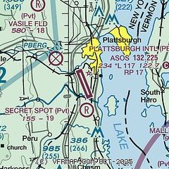
|
CAUTION: Diagram may not be current
 Download PDF
of official airport diagram from the FAA
| Airport distance calculator |
|---|
|
|
| Sunrise and sunset |
|---|
|
Times for 30-Jul-2026
| | Local
(UTC-4) | | Zulu
(UTC) |
|---|
| Morning civil twilight | | 05:05 | | 09:05 |
| Sunrise | | 05:39 | | 09:39 |
| Sunset | | 20:22 | | 00:22 |
| Evening civil twilight | | 20:55 | | 00:55 |
|
| Current date and time |
|---|
| Zulu (UTC) | 30-Jul-2026 19:41:03 |
|---|
| Local (UTC-4) | 30-Jul-2026 15:41:03 |
|---|
|
| METAR |
|---|
| KPBG | 301853Z AUTO 03008KT 10SM FEW050 26/17 A2984 RMK AO2 SLP103 T02610172
|
KBTV
18nm SE | 301854Z 33012KT 10SM SCT028 BKN180 26/18 A2983 RMK AO2 SLP101 T02610178
|
|
| TAF |
|---|
| KPBG | 301737Z 3018/3118 36010KT P6SM SKC FM310100 VRB03KT P6SM SKC FM311500 34005KT P6SM SCT035
|
KBTV
18nm SE | 301737Z 3018/3118 34010KT P6SM FEW028 SCT050 FM310400 09003KT P6SM SKC FM310900 00000KT 3SM BR VCFG FEW001 FM311200 VRB03KT P6SM SCT027
|
|
| NOTAMs |
|---|
NOTAMs are issued by the DoD/FAA and will open in a separate window not controlled by AirNav.
|
|


