FAA INFORMATION EFFECTIVE 09 JULY 2026
Location
| FAA Identifier: | PMU |
| Lat/Long: | 34-21-48.6000N 089-53-34.4000W
34-21.810000N 089-53.573333W
34.3635000,-89.8928889
(estimated) |
| Elevation: | 221.1 ft. / 67.4 m (surveyed) |
| Variation: | 01W (2015) |
| From city: | 4 miles NE of BATESVILLE, MS |
| Time zone: | UTC -5 (UTC -6 during Standard Time) |
| Zip code: | 38606 |
Airport Operations
| Airport use: | Open to the public |
| Activation date: | 03/1963 |
| Control tower: | no |
| ARTCC: | MEMPHIS CENTER |
| FSS: | GREENWOOD FLIGHT SERVICE STATION |
| NOTAMs facility: | GWO (NOTAM-D service available) |
| Attendance: | MON-FRI 0700-1700, ALL SAT-SUN 0800-1700 |
| Wind indicator: | lighted |
| Segmented circle: | yes |
| Lights: | MIRL RWY 01/19 OPR DUSK TO 2200, AFT 2200 - CTAF. PAPI RWY 01 & 19 OPR CONSLY. |
| Beacon: | white-green (lighted land airport)
Operates sunset to sunrise. |
Airport Communications
| CTAF/UNICOM: | 122.8 |
| WX AWOS-3PT: | 118.225 (662-563-6267) |
| WX AWOS-3PT at UOX (18 nm E): | 132.725 (662-234-9751) |
- APCH/DEP SVC PRVDD BY MEMPHIS ARTCC (ZME) ON FREQS 128.5/279.55 (TUPELO RCAG).
Nearby radio navigation aids
| VOR radial/distance | | VOR name | | Freq | | Var |
|---|
| HLIr216/31.3 | | HOLLY SPRINGS VORTAC | | 112.40 | | 03E |
| MEMr172/39.3 | | MEMPHIS VORTAC | | 117.50 | | 01E |
| NDB name | | Hdg/Dist | | Freq | | Var | | ID |
|---|
| TUNNG | | 265/13.3 | | 426 | | 01W | | UV | ..- ...- |
Airport Services
| Fuel available: | 100LL JET-A
100LL:SELF SVC WITH CREDIT CARD 24 HRS; FULL SVC AVBL. |
| Parking: | tiedowns |
| Airframe service: | MAJOR
662-501-5559. |
| Powerplant service: | MAJOR
662-501-5559. |
| Bottled oxygen: | NONE |
| Bulk oxygen: | NONE |
Runway Information
Runway 1/19
| Dimensions: | 5001 x 75 ft. / 1524 x 23 m |
| Surface: | asphalt, in good condition |
| Weight bearing capacity: | |
| Runway edge lights: | medium intensity |
| RUNWAY 1 | | RUNWAY 19 |
| Latitude: | 34-21.403765N | | 34-22.216300N |
| Longitude: | 089-53.656703W | | 089-53.488363W |
| Elevation: | 220.7 ft. | | 218.1 ft. |
| Traffic pattern: | left | | left |
| Runway heading: | 011 magnetic, 010 true | | 191 magnetic, 190 true |
| Displaced threshold: | 589 ft. | | no |
| Markings: | nonprecision, in good condition | | nonprecision, in good condition |
| Visual slope indicator: | 2-light PAPI on left (4.00 degrees glide path) | | 2-light PAPI on left (4.00 degrees glide path) |
| Touchdown point: | yes, no lights | | yes, no lights |
| Instrument approach: | | | LOC/DME |
| Obstructions: | 97 ft. trees, 2300 ft. from runway, 21:1 slope to clear
29:1 GS TO DTHR. | | 33 ft. trees, 920 ft. from runway, 100 ft. right of centerline, 21:1 slope to clear |
Airport Ownership and Management from official FAA records
| Ownership: | Publicly-owned |
| Owner: | PANOLA COUNTY
151 PUBLIC SQUARE
BATESVILLE, MS 38606
Phone 662-563-4100 |
| Manager: | AIRPORT MANAGEMENT SOLUTIONS, LLC
2 AIRPORT RD
BATESVILLE, MS 38606
Phone 662-563-4100 |
Additional Remarks
| - | ULTRALIGHT ACT ON & INVOF ARPT. |
| - | FOR CD CTC MEMPHIS ARTCC AT 901-368-8453/8449. |
| - | CREW CAR AVBL; COML CAR RENTAL NEARBY. |
Instrument Procedures
NOTE: All procedures below are presented as PDF files. If you need a reader for these files, you should download the free Adobe Reader.NOT FOR NAVIGATION. Please procure official charts for flight.
FAA instrument procedures published for use from 09 July 2026 at 0901Z to 06 August 2026 at 0900Z.
IAPs - Instrument Approach Procedures |
|---|
| RNAV (GPS) RWY 01 | |
download (235KB) |
| RNAV (GPS) RWY 19 | |
download (240KB) |
| NOTE: Special Take-Off Minimums/Departure Procedures apply | |
download (306KB) |
Other nearby airports with instrument procedures:
KUOX - University-Oxford Airport (18 nm E)
KMMS - Selfs Airport (21 nm W)
KUTA - Tunica Municipal Airport (30 nm NW)
KCKM - Fletcher Field Airport (31 nm W)
M41 - Holly Springs-Marshall County Airport (32 nm NE)
|
|

Road maps at:
MapQuest
Bing
Google
| Aerial photo |
|---|
WARNING: Photo may not be current or correct
 Photo by Jeff Williams
Photo taken 14-Aug-2008
looking north
Photo by Jeff Williams
Photo taken 14-Aug-2008
looking north
Do you have a better or more recent aerial photo of Panola County Airport that you would like to share? If so, please send us your photo.
|
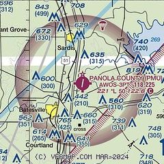
| Sectional chart |
|---|
|
| Airport distance calculator |
|---|
|
|
| Sunrise and sunset |
|---|
|
Times for 10-Jul-2026
| | Local
(UTC-5) | | Zulu
(UTC) |
|---|
| Morning civil twilight | | 05:28 | | 10:28 |
| Sunrise | | 05:56 | | 10:56 |
| Sunset | | 20:13 | | 01:13 |
| Evening civil twilight | | 20:42 | | 01:42 |
|
| Current date and time |
|---|
| Zulu (UTC) | 10-Jul-2026 15:54:10 |
|---|
| Local (UTC-5) | 10-Jul-2026 10:54:10 |
|---|
|
| METAR |
|---|
| KPMU | 101535Z AUTO 23007KT 10SM CLR 31/25 A3004 RMK AO2
|
KUOX
18nm E | 101535Z AUTO VRB06G13KT 10SM CLR 30/23 A3007 RMK AO2
|
|
| TAF |
|---|
KMEM
42nm N | 101120Z 1012/1118 22010G18KT P6SM VCSH BKN070 OVC140 FM101800 21013G20KT P6SM BKN200 FM110100 20010KT P6SM SCT060 BKN100 FM110900 21005KT P6SM VCSH SCT050 BKN200 FM111400 35007KT P6SM SCT100 BKN200
|
|
| NOTAMs |
|---|
NOTAMs are issued by the DoD/FAA and will open in a separate window not controlled by AirNav.
|
|


