FAA INFORMATION EFFECTIVE 14 MAY 2026
Location
| FAA Identifier: | PRZ |
| Lat/Long: | 34-08-43.7330N 103-24-37.2010W
34-08.728883N 103-24.620017W
34.1454814,-103.4103336
(estimated) |
| Elevation: | 4077.8 ft. / 1242.9 m (surveyed) |
| Variation: | 09E (2005) |
| From city: | 4 miles SW of PORTALES, NM |
| Time zone: | UTC -6 (UTC -7 during Standard Time) |
| Zip code: | 88130 |
Airport Operations
| Airport use: | Open to the public |
| Activation date: | 08/1989 |
| Control tower: | no |
| ARTCC: | ALBUQUERQUE CENTER |
| FSS: | ALBUQUERQUE FLIGHT SERVICE STATION |
| NOTAMs facility: | ABQ (NOTAM-D service available) |
| Attendance: | MON-FRI 0700-1600
FOR SVC AFT HRS & WKENDS CALL 505-760-4312. |
| Wind indicator: | lighted |
| Segmented circle: | yes |
| Lights: | PAPI RWY 01 & 19 ON CONSLY; ACTVT OR INCR INTST MIRL RWY 01/19 & 08/26 - CTAF. MIRL RWY 01/19 & 08/26 PRESET LO INTST. |
| Beacon: | white-green (lighted land airport)
Operates sunset to sunrise. |
Airport Communications
| CTAF/UNICOM: | 122.8 |
| WX AWOS-3PT: | 118.175 (575-478-2864) |
| CANNON APPROACH: | 118.425 |
| CANNON DEPARTURE: | 118.425 |
| CLEARANCE DELIVERY: | 119.0 |
Nearby radio navigation aids
| VOR radial/distance | | VOR name | | Freq | | Var |
|---|
| TXOr222/35.2 | | TEXICO VORTAC | | 112.20 | | 11E |
Airport Services
| Fuel available: | 100LL JET-A
100LL:FUEL AVBL H24 SELF SVC VIA CREDIT CARD. |
| Parking: | hangars and tiedowns |
| Airframe service: | MAJOR |
| Powerplant service: | MAJOR |
Runway Information
Runway 1/19
| Dimensions: | 5700 x 60 ft. / 1737 x 18 m |
| Surface: | asphalt, in fair condition |
| Weight bearing capacity: | |
| Runway edge lights: | medium intensity |
| RUNWAY 1 | | RUNWAY 19 |
| Latitude: | 34-08.286928N | | 34-09.152623N |
| Longitude: | 103-24.925553W | | 103-24.486443W |
| Elevation: | 4077.8 ft. | | 4044.0 ft. |
| Traffic pattern: | left | | left |
| Runway heading: | 014 magnetic, 023 true | | 194 magnetic, 203 true |
| Markings: | nonprecision, in good condition | | nonprecision, in good condition |
| Visual slope indicator: | 2-light PAPI on left (3.01 degrees glide path) | | 2-light PAPI on left (3.00 degrees glide path) |
| Touchdown point: | yes, no lights | | yes, no lights |
Runway 8/26
| Dimensions: | 4560 x 60 ft. / 1390 x 18 m |
| Surface: | asphalt, in good condition |
| Weight bearing capacity: | |
| Runway edge lights: | medium intensity |
| RUNWAY 8 | | RUNWAY 26 |
| Latitude: | 34-08.739493N | | 34-08.740987N |
| Longitude: | 103-24.964528W | | 103-24.060482W |
| Elevation: | 4066.3 ft. | | 4058.2 ft. |
| Traffic pattern: | left | | left |
| Runway heading: | 081 magnetic, 090 true | | 261 magnetic, 270 true |
| Markings: | nonprecision, in fair condition | | nonprecision, in fair condition |
| Visual slope indicator: | | | pulsating/steady burning VASI on left (3.00 degrees glide path)
PVASI OTS INDEFLY. |
| Touchdown point: | yes, no lights | | yes, no lights |
| Obstructions: | none | | 30 ft. pline, marked, 1200 ft. from runway, 34:1 slope to clear |
Airport Ownership and Management from official FAA records
| Ownership: | Publicly-owned |
| Owner: | CITY OF PORTALES
100 W 1ST ST
PORTALES, NM 88130-5902
Phone 575-356-6662 |
| Manager: | KELLY MCCLELLAN
181 AIRPORT RD
PORTALES, NM 88130-9108
Phone 575-478-2863
AFT HRS CTC 575-825-0198. |
Additional Remarks
| - | FOR CD CTC ALBUQUERQUE ARTCC AT 505-856-4861. |
Instrument Procedures
NOTE: All procedures below are presented as PDF files. If you need a reader for these files, you should download the free Adobe Reader.NOT FOR NAVIGATION. Please procure official charts for flight.
FAA instrument procedures published for use from 14 May 2026 at 0901Z to 11 June 2026 at 0900Z.
IAPs - Instrument Approach Procedures |
|---|
| RNAV (GPS) RWY 01 **CHANGED** | |
download (191KB) |
| NOTE: Special Alternate Minimums apply | |
download |
| NOTE: Special Take-Off Minimums/Departure Procedures apply | |
download (105KB) |
Other nearby airports with instrument procedures:
KCVS - Cannon Air Force Base (15 nm N)
KCVN - Clovis Regional Airport (24 nm NE)
2T1 - Muleshoe Municipal Airport (38 nm E)
KLIU - Littlefield Taylor Brown Municipal Airport (53 nm E)
KLLN - Levelland Municipal Airport (63 nm SE)
|
|

Road maps at:
MapQuest
Bing
Google
| Aerial photo |
|---|
WARNING: Photo may not be current or correct

Do you have a better or more recent aerial photo of Portales Municipal Airport that you would like to share? If so, please send us your photo.
|
| Sectional chart |
|---|
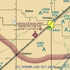
|
| Airport distance calculator |
|---|
|
|
| Sunrise and sunset |
|---|
|
Times for 23-May-2026
| | Local
(UTC-6) | | Zulu
(UTC) |
|---|
| Morning civil twilight | | 05:19 | | 11:19 |
| Sunrise | | 05:48 | | 11:48 |
| Sunset | | 19:53 | | 01:53 |
| Evening civil twilight | | 20:21 | | 02:21 |
|
| Current date and time |
|---|
| Zulu (UTC) | 23-May-2026 23:25:26 |
|---|
| Local (UTC-6) | 23-May-2026 17:25:26 |
|---|
|
| METAR |
|---|
KCVS
14nm N | 232201Z AUTO 20014G21KT 10SM SCT085 29/05 A2996 RMK AO2 WSHFT 00 SLP089 $
|
K4MR
22nm NW | 232255Z AUTO 14004KT 10SM VCTS FEW100 FEW130 29/05 A2993 RMK AO2 SLP061 T02880049 $
|
KCVN
24nm NE | 232256Z AUTO 16010KT 10SM FEW095 30/07 A2997 RMK AO2 SLP114 T03000072 $
|
|
| NOTAMs |
|---|
NOTAMs are issued by the DoD/FAA and will open in a separate window not controlled by AirNav.
|
|


