FAA INFORMATION EFFECTIVE 14 MAY 2026
Location
| FAA Identifier: | RKS |
| Lat/Long: | 41-35-39.1840N 109-03-54.7150W
41-35.653067N 109-03.911917W
41.5942178,-109.0651986
(estimated) |
| Elevation: | 6764.6 ft. / 2061.9 m (surveyed) |
| Variation: | 13E (1995) |
| From city: | 7 miles E of ROCK SPRINGS, WY |
| Time zone: | UTC -6 (UTC -7 during Standard Time) |
| Zip code: | 82901 |
Airport Operations
| Airport use: | Open to the public |
| Activation date: | 07/1942 |
| Control tower: | no |
| ARTCC: | SALT LAKE CITY CENTER |
| FSS: | CASPER FLIGHT SERVICE STATION |
| NOTAMs facility: | RKS (NOTAM-D service available) |
| Attendance: | 0400-2200 |
| Wind indicator: | lighted |
| Segmented circle: | yes |
| Lights: | ACTVT MALSR RWY 27; ODALS RWY 09; REIL RWY 03 & 21; HIRL RWY 09/27 & TWY LGTS - CTAF. PAPI RWY 09, 27, 03, 21 OPR CONSLY. |
| Beacon: | white-green (lighted land airport)
Operates sunset to sunrise. |
| Fire and rescue: | ARFF index A |
| Airline operations: | PPR FOR ACR OPS WITH MORE THAN 30 PAX SEATS 2200-0400 CALL ARPT OPS 307-352-6888. ARFF INDEX C AVBL WITH 30 MIN NOTICE: CALL ARPT OPS 307-352-6888. |
Airport Communications
| CTAF/UNICOM: | 122.8 |
| WX AWOS-3: | 118.375 (307-362-2541) |
- COMMUNICATIONS PRVDD BY CASPER RADIO ON FREQ 122.2 (ROCK SPRINGS RCO).
- APCH/DEP CTL SVC PRVDD BY SALT LAKE ARTCC (ZLC) ON 124.35/353.5 (GREEN RIVER RCAG).
Nearby radio navigation aids
| VOR radial/distance | | VOR name | | Freq | | Var |
|---|
| OCSr263/2.3 | | ROCK SPRINGS VOR/DME | | 116.00 | | 13E |
Airport Services
| Fuel available: | 100LL JET-A1+ |
| Parking: | hangars and tiedowns |
| Airframe service: | MINOR |
| Powerplant service: | MINOR |
| Bottled oxygen: | HIGH/LOW |
Runway Information
Runway 9/27
| Dimensions: | 10002 x 150 ft. / 3049 x 46 m |
| Surface: | asphalt/grooved, in good condition |
| Weight bearing capacity: | | Single wheel: | 55.0 | | Double wheel: | 240.0 | | Double tandem: | 503.0 |
|
| Runway edge lights: | high intensity |
| RUNWAY 9 | | RUNWAY 27 |
| Latitude: | 41-35.860505N | | 41-35.484198N |
| Longitude: | 109-04.933667W | | 109-02.798582W |
| Elevation: | 6731.8 ft. | | 6764.4 ft. |
| Traffic pattern: | left | | left |
| Runway heading: | 090 magnetic, 103 true | | 270 magnetic, 283 true |
| Declared distances: | TORA:10002 TODA:10002 ASDA:10002 LDA:10002 | | TORA:10002 TODA:10002 ASDA:10002 LDA:10002 |
| Markings: | precision, in good condition | | precision, in good condition |
| Visual slope indicator: | 4-light PAPI on left (3.00 degrees glide path) | | 4-light PAPI on left (3.00 degrees glide path) |
| Approach lights: | ODALS: omnidirectional approach lighting system | | MALSR: 1,400 foot medium intensity approach lighting system with runway alignment indicator lights |
| Touchdown point: | yes, no lights | | yes, no lights |
| Instrument approach: | | | ILS/DME |
Runway 3/21
| Dimensions: | 5228 x 75 ft. / 1593 x 23 m |
| Surface: | asphalt/porous friction courses, in good condition |
| Weight bearing capacity: | | Single wheel: | 59.0 | | Double wheel: | 88.0 | | Double tandem: | 159.0 |
|
| Runway edge lights: | medium intensity |
| RUNWAY 3 | | RUNWAY 21 |
| Latitude: | 41-35.312812N | | 41-35.919150N |
| Longitude: | 109-04.406333W | | 109-03.592853W |
| Elevation: | 6733.7 ft. | | 6747.8 ft. |
| Traffic pattern: | left | | left |
| Runway heading: | 032 magnetic, 045 true | | 212 magnetic, 225 true |
| Declared distances: | TORA:5228 TODA:5228 ASDA:5228 LDA:5228 | | TORA:5228 TODA:5228 ASDA:5228 LDA:5228 |
| Markings: | basic, in good condition | | basic, in good condition |
| Visual slope indicator: | 2-light PAPI on left (3.00 degrees glide path) | | 2-light PAPI on left (3.00 degrees glide path) |
| Runway end identifier lights: | yes | | yes |
| Touchdown point: | yes, no lights | | yes, no lights |
Airport Ownership and Management from official FAA records
| Ownership: | Publicly-owned |
| Owner: | ROCK SPRINGS/SWEETWATER COUNTY
BOX 1987
ROCK SPRINGS, WY 82902-1987
Phone 307-352-6880
ROCK SPRINGS/SWEETWATER CO ARPT JOINT PWRS BOARDS. |
| Manager: | DEVON BRUBAKER
382 HWY 370
ROCK SPRINGS, WY 82901-1987
Phone 307-352-6880 |
Additional Remarks
| A39-09/27 | PCR VALUE: 1557/F/A/X/T |
| A39-03/21 | PCR VALUE: 112/F/D/X/T |
| - | FOR CD IF UNA TO CTC ON FSS FREQ, CTC SALT LAKE ARTCC AT 801-320-2568. |
Instrument Procedures
NOTE: All procedures below are presented as PDF files. If you need a reader for these files, you should download the free Adobe Reader.NOT FOR NAVIGATION. Please procure official charts for flight.
FAA instrument procedures published for use from 14 May 2026 at 0901Z to 11 June 2026 at 0900Z.
IAPs - Instrument Approach Procedures |
|---|
| ILS OR LOC RWY 27 | |
download (230KB) |
| RNAV (GPS) RWY 09 | |
download (238KB) |
| RNAV (GPS) RWY 27 | |
download (236KB) |
| VOR RWY 09 | |
download (239KB) |
| VOR/DME RWY 27 | |
download (199KB) |
| NOTE: Special Alternate Minimums apply | |
download (86KB) |
| NOTE: Special Take-Off Minimums/Departure Procedures apply | |
download (223KB) |
Other nearby airports with instrument procedures:
40U - Manila Airport (46 nm SW)
KFBR - Fort Bridger Airport (61 nm W)
KEMM - Kemmerer Municipal Airport (68 nm W)
KVEL - Vernal Regional Airport (72 nm S)
KLND - Hunt Field Airport (75 nm N)
|
|

Road maps at:
MapQuest
Bing
Google
| Aerial photo |
|---|
WARNING: Photo may not be current or correct
 Photo courtesy of Mitch Bowers Imagewerx.us Aerial Photography
Photo taken 12-May-2012
from 11,500' looking north.
Photo courtesy of Mitch Bowers Imagewerx.us Aerial Photography
Photo taken 12-May-2012
from 11,500' looking north.
Do you have a better or more recent aerial photo of Southwest Wyoming Regional Airport that you would like to share? If so, please send us your photo.
|
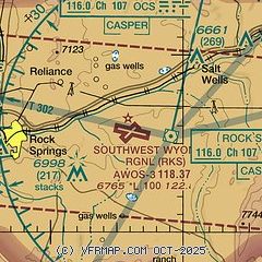
| Sectional chart |
|---|
|
CAUTION: Diagram may not be current

| Airport distance calculator |
|---|
|
|
| Sunrise and sunset |
|---|
|
Times for 24-May-2026
| | Local
(UTC-6) | | Zulu
(UTC) |
|---|
| Morning civil twilight | | 05:17 | | 11:17 |
| Sunrise | | 05:50 | | 11:50 |
| Sunset | | 20:36 | | 02:36 |
| Evening civil twilight | | 21:09 | | 03:09 |
|
| Current date and time |
|---|
| Zulu (UTC) | 24-May-2026 20:37:23 |
|---|
| Local (UTC-6) | 24-May-2026 14:37:23 |
|---|
|
| METAR |
|---|
| KRKS | 241954Z AUTO 20017G25KT 10SM -RA SCT070 OVC090 14/06 A3017 RMK AO2 PK WND 24035/1857 WSHFT 1915 RAB12E25B47 SLP163 P0000 T01440061
|
|
| TAF |
|---|
| KRKS | 241720Z 2418/2518 26014G24KT P6SM SCT080 BKN120 PROB30 2419/2501 25022G36KT -SHRA BKN070 FM250230 25009KT P6SM SCT110 BKN200 FM250800 17005KT P6SM FEW120 SCT200
|
|
| NOTAMs |
|---|
NOTAMs are issued by the DoD/FAA and will open in a separate window not controlled by AirNav.
|
|


