FAA INFORMATION EFFECTIVE 09 JULY 2026
Location
| FAA Identifier: | RST |
| Lat/Long: | 43-54-29.8000N 092-30-00.1000W
43-54.496667N 092-30.001667W
43.9082778,-92.5000278
(estimated) |
| Elevation: | 1317.4 ft. / 401.5 m (surveyed) |
| Variation: | 01W (2025) |
| From city: | 7 miles SW of ROCHESTER, MN |
| Time zone: | UTC -5 (UTC -6 during Standard Time) |
| Zip code: | 55902 |
Airport Operations
| Airport use: | Open to the public |
| Activation date: | 04/1961 |
| Control tower: | yes |
| ARTCC: | MINNEAPOLIS CENTER |
| FSS: | PRINCETON FLIGHT SERVICE STATION |
| NOTAMs facility: | RST (NOTAM-D service available) |
| Attendance: | CONTINUOUS |
| Wind indicator: | lighted |
| Segmented circle: | no |
| Lights: | WHEN ATCT CLSD ACTVT OR INCR INTST MALSR RWY 13; HIRL RWY 13/31; MIRL RWY 03/21 - CTAF. HIRL RWY 13/31 PRESET LOW INTST. PAPI RWY 13, 21, & 31; VASI RWY 03 - OPR CONSLY. |
| Beacon: | white-green (lighted land airport)
Operates sunset to sunrise. |
| Fire and rescue: | ARFF index B |
| Airline operations: | 24 HR PPR FOR UNSKED ACR OPS GTR THAN 9 PAX SEATS BTN 2300-0500 CALL 507-254-1161. |
| International operations: | US CUSTOMS USER FEE ARPT. |
Airport Communications
| CTAF: | 118.3 |
| UNICOM: | 122.95 |
| ATIS: | 120.5 |
| WX ASOS: | PHONE 507-216-8425 |
| ROCHESTER GROUND: | 121.9 [0500-2300] |
| ROCHESTER TOWER: | 118.3 257.8 [0500-2300] |
| ROCHESTER APPROACH: | 119.8 251.125 [0500-2300] |
| ROCHESTER DEPARTURE: | 119.8 251.125 [0500-2300] |
| EMERG: | 121.5 243.0 |
| WX AWOS-3PT at TOB (16 nm NW): | 119.075 (507-374-6369) |
| WX AWOS-3PT at FKA (20 nm SE): | 118.550 (507-765-2182) |
- APCH/DEP SVC PRVDD BY MINNEAPOLIS ARTCC ON FREQS 132.35/307.3 (ROCHESTER RCAG) WHEN ROCHESTER APCH CTL CLSD.
Nearby radio navigation aids
| VOR radial/distance | | VOR name | | Freq | | Var |
|---|
| RSTr024/8.6 | | ROCHESTER VOR/DME | | 112.00 | | 05E |
Airport Services
| Fuel available: | 100LL JET-A
100LL:AVBL 24 HRS WITH CREDIT CARD. |
| Parking: | hangars |
| Airframe service: | MAJOR |
| Powerplant service: | MAJOR |
| Bottled oxygen: | HIGH/LOW |
| Bulk oxygen: | NONE |
Runway Information
Runway 13/31
| Dimensions: | 9034 x 150 ft. / 2754 x 46 m |
| Surface: | concrete/grooved, in good condition |
| Weight bearing capacity: | | Single wheel: | 120.0 | | Double wheel: | 250.0 | | Double tandem: | 400.0 | | Dual double tandem: | 890.0 |
|
| Runway edge lights: | high intensity |
| RUNWAY 13 | | RUNWAY 31 |
| Latitude: | 43-55.209050N | | 43-54.211577N |
| Longitude: | 092-30.727643W | | 092-29.202457W |
| Elevation: | 1268.3 ft. | | 1304.1 ft. |
| Traffic pattern: | left | | left |
| Runway heading: | 133 magnetic, 132 true | | 313 magnetic, 312 true |
| Declared distances: | TORA:9033 TODA:9033 ASDA:9033 LDA:9033 | | TORA:9033 TODA:9033 ASDA:9033 LDA:9033 |
| Markings: | precision, in good condition | | precision, in good condition |
| Visual slope indicator: | 4-light PAPI on left (3.00 degrees glide path) | | 4-light PAPI on left (3.00 degrees glide path) |
| RVR equipment: | touchdown, midfield, rollout
RVR UNAVBL WHEN ATCT CLSD. | | touchdown, midfield, rollout
RVR UNAVBL WHEN ATCT CLSD. |
| Approach lights: | MALSR: 1,400 foot medium intensity approach lighting system with runway alignment indicator lights | | ALSF2: standard 2,400 foot high intensity approach lighting system with centerline sequenced flashers (category II or III) |
| Centerline lights: | yes | | yes |
| Touchdown point: | yes, lighted | | yes, lighted |
| Instrument approach: | ILS | | ILS |
Runway 3/21
| Dimensions: | 7301 x 150 ft. / 2225 x 46 m |
| Surface: | asphalt/concrete/grooved, in good condition
RWY 03 END 2075 FT CONC, MID 3777 FT ASPHALT, RWY 21 END 1449 FT CONC. |
| Weight bearing capacity: | | Single wheel: | 120.0 | | Double wheel: | 250.0 | | Double tandem: | 370.0 | | Dual double tandem: | 890.0 |
|
| Runway edge lights: | medium intensity |
| RUNWAY 3 | | RUNWAY 21 |
| Latitude: | 43-53.695707N | | 43-54.771398N |
| Longitude: | 092-30.415618W | | 092-29.674778W |
| Elevation: | 1314.6 ft. | | 1282.0 ft. |
| Traffic pattern: | left | | left |
| Runway heading: | 027 magnetic, 026 true | | 207 magnetic, 206 true |
| Declared distances: | TORA:7300 TODA:7300 ASDA:7300 LDA:7300 | | TORA:7300 TODA:7300 ASDA:7300 LDA:7300 |
| Markings: | nonprecision, in good condition | | nonprecision, in good condition |
| Visual slope indicator: | 4-box VASI on left (3.00 degrees glide path) | | 4-light PAPI on left (3.05 degrees glide path) |
| Runway end identifier lights: | yes | | yes |
| Touchdown point: | yes, no lights | | yes, no lights |
Airport Ownership and Management from official FAA records
| Ownership: | Publicly-owned |
| Owner: | CITY OF ROCHESTER
CITY HALL, 201 4TH ST SE
ROCHESTER, MN 55904-3708
Phone 507-254-1161 |
| Manager: | JOHN C REED
7600 HELGERSON DR SW
ROCHESTER, MN 55902-1838
Phone 507-254-1161 |
Additional Remarks
| A39-13/31 | PCR VALUE: 890/R/D/W/T |
| A39-03/21 | PCR VALUE: 890/F/D/X/T |
| - | WHEN ATCT CLSD SNOW REMOVAL EQPT PSNL MNT CTAF. |
| - | WATERFOWL ON & INVOF ARPT. |
| - | US CUST AVBL MON-FRI 0830-1700; PN AFT HRS & WKENDS CALL 507-285-5278. |
| - | FOR CD WHEN ATCT IS CLSD CTC FSS VIA RCO, IF UNA CTC MINNEAPOLIS ARTCC AT 651-463-5588. |
Instrument Procedures
NOTE: All procedures below are presented as PDF files. If you need a reader for these files, you should download the free Adobe Reader.NOT FOR NAVIGATION. Please procure official charts for flight.
FAA instrument procedures published for use from 09 July 2026 at 0901Z to 06 August 2026 at 0900Z.
IAPs - Instrument Approach Procedures |
|---|
| ILS OR LOC RWY 13 | |
download (222KB) |
| ILS Z OR LOC Z RWY 31 | |
download (253KB) |
| ILS Z RWY 31 (SA CAT I) | |
download (236KB) |
| ILS Z RWY 31 (CAT II) | |
download (225KB) |
| RNAV (GPS) RWY 03 | |
download (220KB) |
| RNAV (GPS) RWY 13 | |
download (248KB) |
| RNAV (GPS) RWY 21 | |
download (235KB) |
| RNAV (GPS) RWY 31 | |
download (214KB) |
| COPTER ILS Y OR LOC Y RWY 31 | |
download (223KB) |
| NOTE: Special Alternate Minimums apply | |
download (176KB) |
| NOTE: Special Take-Off Minimums/Departure Procedures apply | |
download (412KB) |
Other nearby airports with instrument procedures:
KTOB - Dodge Center Airport (16 nm NW)
KFKA - Fillmore County Airport (20 nm SE)
KAUM - Austin Municipal Airport (24 nm SW)
55Y - Rushford Municipal Airport/Robert W Bunke Field (30 nm E)
KOWA - Owatonna Degner Regional Airport (35 nm W)
|
|

Road maps at:
MapQuest
Bing
Google
| Aerial photo |
|---|
WARNING: Photo may not be current or correct
 Photo taken 14-Apr-2007
Do you have a better or more recent aerial photo of Rochester International Airport that you would like to share? If so, please send us your photo.
|
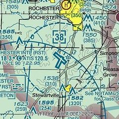
| Sectional chart |
|---|
|
 Download PDF
of official airport diagram from the FAA
| Airport distance calculator |
|---|
|
|
| Sunrise and sunset |
|---|
|
Times for 11-Jul-2026
| | Local
(UTC-5) | | Zulu
(UTC) |
|---|
| Morning civil twilight | | 05:04 | | 10:04 |
| Sunrise | | 05:39 | | 10:39 |
| Sunset | | 20:52 | | 01:52 |
| Evening civil twilight | | 21:27 | | 02:27 |
|
| Current date and time |
|---|
| Zulu (UTC) | 11-Jul-2026 12:15:09 |
|---|
| Local (UTC-5) | 11-Jul-2026 07:15:09 |
|---|
|
| METAR |
|---|
| KRST | 111154Z 16004KT 5SM BR CLR 20/19 A3010 RMK AO2 SLP186 T02000189 10206 20183 53019 $
|
K9MN
7nm N | 110607Z AUTO 13005KT 10SM CLR RMK AO1
|
KTOB
15nm NW | 111155Z AUTO 16003KT 10SM CLR 19/19 A3009 RMK AO2 T01920192 10201 20180 53018
|
KFKA
19nm SE | 111155Z AUTO 00000KT 9SM CLR 20/20 A3009 RMK AO2
|
|
| TAF |
|---|
| KRST | 111020Z 1110/1206 17004KT 3SM BR SKC TEMPO 1110/1112 1SM BR FM111300 17005KT P6SM FEW045
|
|
| NOTAMs |
|---|
NOTAMs are issued by the DoD/FAA and will open in a separate window not controlled by AirNav.
|
|


