FAA INFORMATION EFFECTIVE 16 APRIL 2026
Location
| FAA Identifier: | RUE |
| Lat/Long: | 35-15-33.4190N 093-05-33.4400W
35-15.556983N 093-05.557333W
35.2592831,-93.0926222
(estimated) |
| Elevation: | 409.2 ft. / 124.7 m (surveyed) |
| Variation: | 03E (1995) |
| From city: | 2 miles SE of RUSSELLVILLE, AR |
| Time zone: | UTC -5 (UTC -6 during Standard Time) |
| Zip code: | 72802 |
Airport Operations
| Airport use: | Open to the public |
| Activation date: | 09/1960 |
| Control tower: | no |
| ARTCC: | MEMPHIS CENTER |
| FSS: | JONESBORO FLIGHT SERVICE STATION |
| NOTAMs facility: | RUE (NOTAM-D service available) |
| Attendance: | SAT-SUN 0800-1800, NOV-MAR M-F 0730-1730, MAR-NOV M-F 0730-1830
FOR SVC AFT HRS CALL 479-857-0362 OR 479-857-4076. |
| Pattern altitude: | 1414.2 ft. MSL |
| Wind indicator: | lighted |
| Segmented circle: | yes |
| Lights: | DUSK-DAWN. ACTVT REIL RWYS 07 & 25; PAPI RWYS 07 & 25; MIRL 07/25 - CTAF. |
| Beacon: | white-green (lighted land airport)
Operates sunset to sunrise. |
Airport Communications
| CTAF/UNICOM: | 122.7 |
| WX ASOS: | 132.475 (479-968-2267) |
- APCH/DEP SVC PRVDD BY MEMPHIS ARTCC ON FREQS 128.475/377.15 (RUSSELLVILLE RCAG).
Nearby radio navigation aids
| NDB name | | Hdg/Dist | | Freq | | Var | | ID |
|---|
| RUSSELLVILLE | | at field | | 379 | | 03E | | RUE | .-. ..- . |
Airport Services
| Fuel available: | 100LL JET-A
100LL:SELF SVC FUEL AVBL 24 HRS WITH CREDIT CARD (100 LL) |
| Parking: | tiedowns |
| Airframe service: | NONE |
| Powerplant service: | NONE |
| Bottled oxygen: | NONE |
| Bulk oxygen: | NONE |
Runway Information
Runway 7/25
| Dimensions: | 5505 x 75 ft. / 1678 x 23 m |
| Surface: | asphalt, in good condition |
| Weight bearing capacity: | | Single wheel: | 32.0 | | Double wheel: | 46.0 |
|
| Runway edge lights: | medium intensity |
| RUNWAY 7 | | RUNWAY 25 |
| Latitude: | 35-15.439928N | | 35-15.673993N |
| Longitude: | 093-06.091783W | | 093-05.022870W |
| Elevation: | 370.1 ft. | | 409.2 ft. |
| Traffic pattern: | left | | left |
| Runway heading: | 072 magnetic, 075 true | | 252 magnetic, 255 true |
| Displaced threshold: | no | | 706 ft. |
| Markings: | nonprecision, in good condition | | nonprecision, in good condition |
| Visual slope indicator: | 4-light PAPI on left (3.00 degrees glide path) | | 4-light PAPI on left (4.00 degrees glide path) |
| Runway end identifier lights: | yes | | yes |
| Touchdown point: | yes, no lights | | yes, no lights |
| Obstructions: | 35 ft. tree, 1475 ft. from runway, 125 ft. right of centerline, 36:1 slope to clear | | 78 ft. tree, 1825 ft. from runway, 115 ft. right of centerline, 20:1 slope to clear
APCH SLOPE 29:1 TO DSPLCD THLD. |
Airport Ownership and Management from official FAA records
| Ownership: | Publicly-owned |
| Owner: | CITY OF RUSSELLVILLE
203 S. COMMERCE STR
RUSSELLVILLE, AR 72801
Phone 479-968-2098 |
| Manager: | PATRICK KARP
1759 AIRPORT ROAD
RUSSELLVILLE, AR 72802
Phone 479-967-1227 |
Additional Remarks
| - | FLOCKS OF MIGRATORY BIRDS INVOF ARPT. |
| - | DEER ON & INVOF RY. |
| - | FOR CD CTC MEMPHIS ARTCC AT 901-368-8453/8449. |
| - | HELI SERVICE CENTER ON FLD. |
Instrument Procedures
NOTE: All procedures below are presented as PDF files. If you need a reader for these files, you should download the free Adobe Reader.NOT FOR NAVIGATION. Please procure official charts for flight.
FAA instrument procedures published for use from 16 April 2026 at 0901Z to 14 May 2026 at 0900Z.
IAPs - Instrument Approach Procedures |
|---|
| RNAV (GPS) RWY 07 | |
download (250KB) |
| RNAV (GPS) RWY 25 | |
download (201KB) |
| NDB-A | |
download (173KB) |
| NOTE: Special Alternate Minimums apply | |
download (121KB) |
| NOTE: Special Take-Off Minimums/Departure Procedures apply | |
download (453KB) |
Other nearby airports with instrument procedures:
KMPJ - Petit Jean Park Airport (12 nm SE)
32A - Danville Municipal Airport (19 nm SW)
KBDQ - Morrilton Municipal Airport (20 nm E)
H35 - Clarksville Municipal Airport (21 nm NW)
KCXW - Conway Regional Airport (30 nm SE)
|
|

Road maps at:
MapQuest
Bing
Google
| Aerial photo |
|---|
WARNING: Photo may not be current or correct
 Taken in 2014
looking north.
Taken in 2014
looking north.
Do you have a better or more recent aerial photo of Russellville Regional Airport that you would like to share? If so, please send us your photo.
|
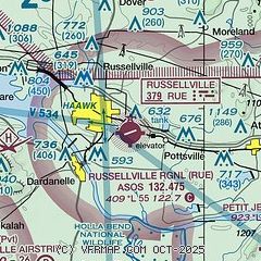
| Sectional chart |
|---|
|
| Airport distance calculator |
|---|
|
|
| Sunrise and sunset |
|---|
|
Times for 09-May-2026
| | Local
(UTC-5) | | Zulu
(UTC) |
|---|
| Morning civil twilight | | 05:46 | | 10:46 |
| Sunrise | | 06:14 | | 11:14 |
| Sunset | | 20:03 | | 01:03 |
| Evening civil twilight | | 20:31 | | 01:31 |
|
| Current date and time |
|---|
| Zulu (UTC) | 09-May-2026 09:27:08 |
|---|
| Local (UTC-5) | 09-May-2026 04:27:08 |
|---|
|
| METAR |
|---|
| KRUE | 090853Z AUTO 33005KT 10SM CLR 16/14 A2981 RMK AO2 SLP089 T01610139 58003
|
|
| TAF |
|---|
KHOT
47nm S | 090520Z 0906/1006 VRB04KT P6SM BKN120 FM091500 29004KT P6SM SKC FM092000 VRB05KT P6SM SKC
|
|
| NOTAMs |
|---|
NOTAMs are issued by the DoD/FAA and will open in a separate window not controlled by AirNav.
|
|

