FAA INFORMATION EFFECTIVE 22 JANUARY 2026
Location
| FAA Identifier: | SAD |
| Lat/Long: | 32-51-12.0280N 109-38-06.2950W
32-51.200467N 109-38.104917W
32.8533411,-109.6350819
(estimated) |
| Elevation: | 3178.4 ft. / 968.8 m (surveyed) |
| Variation: | 12E (1985) |
| From city: | 3 miles E of SAFFORD, AZ |
| Time zone: | UTC -7 (year round; does not observe DST) |
| Zip code: | 85546 |
Airport Operations
| Airport use: | Open to the public |
| Activation date: | 07/1942 |
| Control tower: | no |
| ARTCC: | ALBUQUERQUE CENTER |
| FSS: | PRESCOTT FLIGHT SERVICE STATION |
| NOTAMs facility: | SAD (NOTAM-D service available) |
| Attendance: | MON-SAT 0700-1800
AFT HR; CALL OUT FEE - 928-432-4237. |
| Wind indicator: | lighted |
| Segmented circle: | yes |
| Lights: | ACTVT REIL RWY 08, 12, 26 & 30; PAPI RWY 08, 12, 26, & 30; MIRL RWY 08/26 & RWY 12/30 - CTAF. |
| Beacon: | white-green (lighted land airport)
Operates sunset to sunrise. |
| Landing fee: | yes |
| Airline operations: | ARFF INDEX B. |
Airport Communications
| CTAF/UNICOM: | 122.8 |
| WX ASOS: | 124.175 (928-235-2373) |
- APCH/DEP SVC PRVDD BY ALBUQUERQUE ARTCC (ZAB) ON FREQS 134.45/327.15 (SILVER CITY RCAG).
Nearby radio navigation aids
| VOR radial/distance | | VOR name | | Freq | | Var |
|---|
| SSOr319/39.8 | | SAN SIMON VORTAC | | 115.40 | | 13E |
Airport Services
| Fuel available: | 100LL JET-A+
100LL:H24 WITH CREDIT CARD. |
| Parking: | hangars and tiedowns |
| Airframe service: | MAJOR |
| Powerplant service: | MAJOR |
| Bottled oxygen: | HIGH/LOW |
| Bulk oxygen: | HIGH/LOW |
Runway Information
Runway 12/30
| Dimensions: | 6007 x 100 ft. / 1831 x 30 m |
| Surface: | asphalt, in good condition |
| Weight bearing capacity: | | PCN 45 /F/C/Y/T | | Single wheel: | 70.0 | | Double wheel: | 147.0 | | Double tandem: | 201.0 |
|
| Runway edge lights: | medium intensity |
| RUNWAY 12 | | RUNWAY 30 |
| Latitude: | 32-51.522043N | | 32-50.817043N |
| Longitude: | 109-38.527765W | | 109-37.703570W |
| Elevation: | 3165.6 ft. | | 3169.0 ft. |
| Traffic pattern: | left | | left |
| Runway heading: | 123 magnetic, 135 true | | 303 magnetic, 315 true |
| Markings: | nonprecision, in good condition | | nonprecision, in good condition |
| Visual slope indicator: | 2-light PAPI on left (3.00 degrees glide path) | | 2-light PAPI on left (3.00 degrees glide path) |
| Runway end identifier lights: | yes | | yes |
| Touchdown point: | yes, no lights | | yes, no lights |
Runway 8/26
| Dimensions: | 4802 x 60 ft. / 1464 x 18 m |
| Surface: | asphalt, in good condition |
| Weight bearing capacity: | |
| Runway edge lights: | medium intensity |
| RUNWAY 8 | | RUNWAY 26 |
| Latitude: | 32-51.241800N | | 32-51.236467N |
| Longitude: | 109-38.560455W | | 109-37.622552W |
| Elevation: | 3160.1 ft. | | 3178.4 ft. |
| Traffic pattern: | left | | left |
| Runway heading: | 078 magnetic, 090 true | | 258 magnetic, 270 true |
| Markings: | basic, in good condition | | basic, in good condition |
| Visual slope indicator: | 2-light PAPI on left (3.00 degrees glide path) | | 2-light PAPI on left (3.00 degrees glide path) |
| Runway end identifier lights: | yes | | yes |
| Touchdown point: | yes, no lights | | yes, no lights |
Helipad H1
| Dimensions: | 72 x 72 ft. / 22 x 22 m |
| Surface: | concrete |
| Latitude: | 32-51.008500N | | |
| Longitude: | 109-38.464167W | | |
| Elevation: | 3158.0 ft. | | |
| Traffic pattern: | left | | left |
Airport Ownership and Management from official FAA records
| Ownership: | Publicly-owned |
| Owner: | CITY OF SAFFORD
717 MAIN ST
SAFFORD, AZ 85546
Phone 928-432-4000 |
| Manager: | CAMERON ATKINS
4570 E AVIATION WAY
SAFFORD, AZ 85546-0272
Phone 928-432-4235
EMERG - 435-359-7115. |
Additional Remarks
| - | MIL ACT INVOF ARPT. |
| - | FOR CD IF UNA TO CTC ON FSS FREQ, CTC ALBUQUERQUE ARTCC AT 505-856-4561. |
| - | LNDG FEE OVR 4000 LB MTOW; MIL/GOV/CHARITY WAIVED OR WITH FUEL PURCHASE. |
Instrument Procedures
NOTE: All procedures below are presented as PDF files. If you need a reader for these files, you should download the free Adobe Reader.NOT FOR NAVIGATION. Please procure official charts for flight.
FAA instrument procedures published for use from 22 January 2026 at 0901Z to 19 February 2026 at 0900z.
IAPs - Instrument Approach Procedures |
|---|
| RNAV (GPS) RWY 12 | |
download (369KB) |
| RNAV (GPS) RWY 30 | |
download (362KB) |
| NOTE: Special Alternate Minimums apply | |
download (143KB) |
|
|---|
| SAFFORD ONE (OBSTACLE) (RNAV) | |
download (183KB) |
| NOTE: Special Take-Off Minimums/Departure Procedures apply | |
download (386KB) |
Other nearby airports with instrument procedures:
KCFT - Greenlee County Airport (22 nm E)
P33 - Cochise County Airport (39 nm S)
P13 - San Carlos Apache Airport (60 nm NW)
KDMA - Davis Monthan Air Force Base (75 nm SW)
KSVC - Grant County Airport (76 nm E)
|
|

Road maps at:
MapQuest
Bing
Google
| Aerial photo |
|---|
WARNING: Photo may not be current or correct
 Photo by Trent Thomas
Photo taken 02-Mar-2019
at 4,500 feet looking north.
Photo by Trent Thomas
Photo taken 02-Mar-2019
at 4,500 feet looking north.
Do you have a better or more recent aerial photo of Safford Regional Airport/1LT Duane Spalsbury Field that you would like to share? If so, please send us your photo.
|
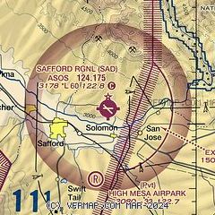
| Sectional chart |
|---|
|
| Airport distance calculator |
|---|
|
|
| Sunrise and sunset |
|---|
|
Times for 16-Feb-2026
| | Local
(UTC-7) | | Zulu
(UTC) |
|---|
| Morning civil twilight | | 06:37 | | 13:37 |
| Sunrise | | 07:02 | | 14:02 |
| Sunset | | 18:04 | | 01:04 |
| Evening civil twilight | | 18:29 | | 01:29 |
|
| Current date and time |
|---|
| Zulu (UTC) | 16-Feb-2026 18:56:21 |
|---|
| Local (UTC-7) | 16-Feb-2026 11:56:21 |
|---|
|
| METAR |
|---|
| KSAD | 161751Z AUTO 08008G18KT 10SM CLR 19/02 A3000 RMK AO2 SLP131 T01890017 10189 20089 51010 $
|
|
| NOTAMs |
|---|
NOTAMs are issued by the DoD/FAA and will open in a separate window not controlled by AirNav.
|
|


