FAA INFORMATION EFFECTIVE 22 JANUARY 2026
Location
| FAA Identifier: | SBS |
| Lat/Long: | 40-30-58.5390N 106-51-58.6860W
40-30.975650N 106-51.978100W
40.5162608,-106.8663017
(estimated) |
| Elevation: | 6882.4 ft. / 2097.8 m (surveyed) |
| Variation: | 10E (2010) |
| From city: | 3 miles NW of STEAMBOAT SPRINGS, CO |
| Time zone: | UTC -7 (UTC -6 during Daylight Saving Time) |
| Zip code: | 80487 |
Airport Operations
| Airport use: | Open to the public |
| Activation date: | 01/1942 |
| Control tower: | no |
| ARTCC: | DENVER CENTER |
| FSS: | DENVER FLIGHT SERVICE STATION |
| NOTAMs facility: | SBS (NOTAM-D service available) |
| Attendance: | NOV-APR 0700-1700, MAY-OCT 0700-1700 |
| Wind indicator: | lighted |
| Segmented circle: | yes |
| Lights: | ACTVT REIL RWY 32; PAPI RWY 32; HIRL RWY 14/32 - CTAF. |
| Beacon: | white-green (lighted land airport)
Operates sunset to sunrise. |
| Landing fee: | yes, NO LDG FEE FOR SNGL ENG PISTON ACFT. |
Airport Communications
| CTAF/UNICOM: | 122.8 |
| WX AWOS-3: | 118.325 (970-879-7794) |
| WX AWOS-3PT at HDN (16 nm W): | 119.275 (970-276-3690) |
- UNICOM AVBL 0700-1700.
- APCH/DEP CTL SVC PRVDD BY DENVER ARTCC (ZDV) FREQS 120.475/235.975 (HAYDEN RCAG).
- COMMUNICATIONS PRVDD BY DENVER RADIO ON FREQ 122.2 (STEAMBOAT SPRINGS RCO).
Nearby radio navigation aids
| VOR radial/distance | | VOR name | | Freq | | Var |
|---|
| BQZr352/3.2 | | ROBERT VOR/DME | | 112.20 | | 13E |
| CHEr077/20.0 | | HAYDEN VOR/DME | | 115.60 | | 14E |
| RLGr314/36.4 | | KREMMLING VOR/DME | | 113.80 | | 14E |
Airport Services
| Fuel available: | 100LL JET-A |
| Parking: | hangars and tiedowns |
| Airframe service: | MINOR |
| Powerplant service: | MINOR |
| Bottled oxygen: | HIGH/LOW |
| Bulk oxygen: | HIGH/LOW |
Runway Information
Runway 14/32
| Dimensions: | 4452 x 100 ft. / 1357 x 30 m |
| Surface: | asphalt/grooved, in good condition |
| Weight bearing capacity: | | Single wheel: | 50.0 | | Double wheel: | 60.0 |
|
| Runway edge lights: | high intensity |
| RUNWAY 14 | | RUNWAY 32 |
| Latitude: | 40-31.301848N | | 40-30.649435N |
| Longitude: | 106-52.196993W | | 106-51.759230W |
| Elevation: | 6874.7 ft. | | 6882.1 ft. |
| Traffic pattern: | right | | left |
| Runway heading: | 143 magnetic, 153 true | | 323 magnetic, 333 true |
| Displaced threshold: | no | | 600 ft. |
| Declared distances: | TORA:4452 TODA:4452 ASDA:3852 LDA:3852 | | TORA:4452 TODA:4452 ASDA:4452 LDA:3852 |
| Markings: | basic, in good condition | | nonprecision, in good condition |
| Visual slope indicator: | | | 2-light PAPI on left (4.00 degrees glide path)
PAPI BAFFLED; VIS LMTD TO 5.5 DEGS LEFT OF CNTRLN DUE TO HIGH TRRN. |
| Runway end identifier lights: | | | yes |
| Touchdown point: | yes, no lights | | yes, no lights |
Airport Ownership and Management from official FAA records
| Ownership: | Publicly-owned |
| Owner: | CITY OF STEAMBOAT SPRINGS
PO BOX 775088
STEAMBOAT SPRINGS, CO 80477
Phone 970-879-1204 |
| Manager: | JOSHUA SCHROEDER
3499 AIRPORT CIRCLE
STEAMBOAT SPRINGS, CO 80477
Phone 970-879-9042 |
Additional Remarks
| A58-32 | BRUSH 176 FT FM RWY END, 98 FT FM DSP THLD, 124 FT RT OF APCH, 7 FT ABV RWY END. |
| A30A-32 | PREFERRED RWY; 180 FT DROPOFF 2000 FT FM PAVEMENT END. |
| - | WILDLIFE ON & INVOF ARPT. |
| - | COLD TEMPERATURE AIRPORT. ALTITUDE CORRECTION REQUIRED AT OR BELOW -25C. |
| - | FOR CD IF UNA TO CTC ON FSS FREQ, CTC DENVER ARTCC AT 303-651-4257. |
| - | SI NA TO AVOID TFC CONFLICTS. |
Instrument Procedures
NOTE: All procedures below are presented as PDF files. If you need a reader for these files, you should download the free Adobe Reader.NOT FOR NAVIGATION. Please procure official charts for flight.
FAA instrument procedures published for use from 22 January 2026 at 0901Z to 19 February 2026 at 0900z.
IAPs - Instrument Approach Procedures |
|---|
| RNAV (GPS) Z RWY 32 | |
download (355KB) |
| RNAV (GPS)-E | |
download (362KB) |
| VOR/DME-C | |
download (390KB) |
| NOTE: Special Alternate Minimums apply | |
download (145KB) |
| NOTE: Special Take-Off Minimums/Departure Procedures apply | |
download (298KB) |
Other nearby airports with instrument procedures:
KHDN - Yampa Valley Airport (16 nm W)
KCAG - Craig-Moffat Airport (30 nm W)
33V - Walden-Jackson County Airport (31 nm NE)
20V - Mc Elroy Airfield (36 nm SE)
KDWX - Dixon Airport (42 nm NW)
|
|

Road maps at:
MapQuest
Bing
Google
| Aerial photo |
|---|
WARNING: Photo may not be current or correct
 Photo by Mitch Bowers imagewerx.us
Photo taken 23-Aug-2017
looking south.
Photo by Mitch Bowers imagewerx.us
Photo taken 23-Aug-2017
looking south.
Do you have a better or more recent aerial photo of Steamboat Springs Airport/Bob Adams Field that you would like to share? If so, please send us your photo.
|
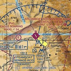
| Sectional chart |
|---|
|
| Airport distance calculator |
|---|
|
|
| Sunrise and sunset |
|---|
|
Times for 02-Feb-2026
| | Local
(UTC-7) | | Zulu
(UTC) |
|---|
| Morning civil twilight | | 06:48 | | 13:48 |
| Sunrise | | 07:17 | | 14:17 |
| Sunset | | 17:25 | | 00:25 |
| Evening civil twilight | | 17:54 | | 00:54 |
|
| Current date and time |
|---|
| Zulu (UTC) | 03-Feb-2026 04:14:47 |
|---|
| Local (UTC-7) | 02-Feb-2026 21:14:47 |
|---|
|
| METAR |
|---|
| KSBS | 030355Z AUTO 00000KT 10SM CLR M03/M09 A3027 RMK AO1 T10291092
|
KHDN
16nm W | 030356Z AUTO 29004KT 10SM CLR M01/M07 A3030 RMK AO2 SLP283 T10111067 FZRANO $
|
|
| TAF |
|---|
KHDN
16nm W | 021720Z 0218/0318 10006KT P6SM FEW120 BKN250 FM022100 29007KT P6SM BKN250 FM030300 11009KT P6SM FEW250
|
|
| NOTAMs |
|---|
NOTAMs are issued by the DoD/FAA and will open in a separate window not controlled by AirNav.
|
|


