FAA INFORMATION EFFECTIVE 14 MAY 2026
Location
| FAA Identifier: | SGU |
| Lat/Long: | 37-02-10.9610N 113-30-37.0900W
37-02.182683N 113-30.618167W
37.0363781,-113.5103028
(estimated) |
| Elevation: | 2883.6 ft. / 878.9 m (surveyed) |
| Variation: | 12E (2010) |
| From city: | 5 miles SE of ST GEORGE, UT |
| Time zone: | UTC -6 (UTC -7 during Standard Time) |
| Zip code: | 84790 |
Airport Operations
| Airport use: | Open to the public |
| Activation date: | 01/2011 |
| Control tower: | no |
| ARTCC: | LOS ANGELES CENTER |
| FSS: | CEDAR CITY FLIGHT SERVICE STATION |
| NOTAMs facility: | SGU (NOTAM-D service available) |
| Attendance: | 0600-2400 |
| Wind indicator: | lighted |
| Segmented circle: | yes |
| Lights: | ACTVT MALSR RWY 19; REIL RWY 01; HIRL RWY 01/19 - CTAF. PAPI RWY 01 & 19 ON CONSLY. |
| Beacon: | white-green (lighted land airport) |
| Landing fee: | yes, ACFT +12500 LB. |
| Fire and rescue: | ARFF index B |
Airport Communications
| CTAF/UNICOM: | 123.075 |
| WX AWOS-3PT: | 135.075 (435-634-0940) |
- APCH/DEP CTL SVC PRVDD BY LOS ANGELES ARTCC (ZLA) ON FREQS 124.2/343.6 (CEDAR CITY RCAG).
- CLNC DEL PRVDD BY LOS ANGELES ARTCC ON FREQ 133.3.
Nearby radio navigation aids
| VOR radial/distance | | VOR name | | Freq | | Var |
|---|
| UTIr006/1.2 | | ST GEORGE VOR/DME | | 108.60 | | 12E |
Airport Services
| Fuel available: | 100LL JET-A |
| Parking: | hangars and tiedowns |
| Airframe service: | MAJOR |
| Powerplant service: | MAJOR |
| Bulk oxygen: | LOW |
Runway Information
Runway 1/19
| Dimensions: | 9300 x 150 ft. / 2835 x 46 m |
| Surface: | asphalt/grooved, in good condition |
| Weight bearing capacity: | | Single wheel: | 75.0 | | Double wheel: | 150.0 |
|
| Runway edge lights: | high intensity |
| RUNWAY 1 | | RUNWAY 19 |
| Latitude: | 37-01.477355N | | 37-02.887997N |
| Longitude: | 113-30.991393W | | 113-30.244812W |
| Elevation: | 2831.7 ft. | | 2883.6 ft. |
| Traffic pattern: | left | | left |
| Runway heading: | 011 magnetic, 023 true | | 191 magnetic, 203 true |
| Declared distances: | TORA:9300 TODA:9300 ASDA:9300 LDA:9300 | | TORA:9300 TODA:9300 ASDA:9300 LDA:9300 |
| Markings: | precision, in good condition | | precision, in good condition |
| Visual slope indicator: | 4-light PAPI on left (3.00 degrees glide path) | | 4-light PAPI on left (3.10 degrees glide path) |
| Approach lights: | | | MALSR: 1,400 foot medium intensity approach lighting system with runway alignment indicator lights |
| Runway end identifier lights: | yes | | no |
| Touchdown point: | yes, no lights | | yes, no lights |
| Instrument approach: | | | LDA/DME |
Airport Ownership and Management from official FAA records
| Ownership: | Publicly-owned |
| Owner: | CITY OF ST GEORGE
175 E 200 N
ST GEORGE, UT 84770
Phone 435-627-4000 |
| Manager: | DUSTIN WARREN
4508 S. AIRPORT PKWY #1
ST GEORGE, UT 84790
Phone 435-627-4087 |
Additional Remarks
| A39-01/19 | PCR VALUE: 300/F/D/X/T |
| A30A-19 | CALM WIND RWY. |
| - | PPR OVR 150000 LB - AMGR. |
| - | COLD TEMPERATURE AIRPORT. ALTITUDE CORRECTION REQUIRED AT OR BELOW -5C. |
| - | NO ACFT TKOFS/LNDGS ON UNPAVED/DIRT RWY SAFETY AREAS ADJ TO ALL RWYS. |
| - | OFF RWY LNDGS NOT PMTD. CTAF INTRPN MAY OCCUR DUE TO AFLD CURVATURE BTN ALPHA 1 AND ALPHA 5. |
| - | RWY 1/19, A, A1, A2, A4, A5 & TERM AVBL TO ACRS. |
Instrument Procedures
NOTE: All procedures below are presented as PDF files. If you need a reader for these files, you should download the free Adobe Reader.NOT FOR NAVIGATION. Please procure official charts for flight.
FAA instrument procedures published for use from 14 May 2026 at 0901Z to 11 June 2026 at 0900Z.
IAPs - Instrument Approach Procedures |
|---|
| RNAV (GPS) RWY 01 **CHANGED** | |
download (376KB) |
| RNAV (GPS) RWY 19 **CHANGED** | |
download (759KB) |
| LDA RWY 19 **CHANGED** | |
download (861KB) |
| NOTE: Special Alternate Minimums apply | |
download (120KB) |
Departure Procedures |
|---|
| HIVKA TWO (RNAV) | |
download (169KB) |
| PHYLI TWO (RNAV) | |
download (138KB) |
|
|---|
| JITKA TWO (OBSTACLE) | |
download (240KB) |
| NOTE: Special Take-Off Minimums/Departure Procedures apply | |
download (161KB) |
Other nearby airports with instrument procedures:
KAZC - Colorado City Municipal Airport (24 nm E)
67L - Mesquite Airport (29 nm SW)
KCDC - Cedar City Regional Airport (44 nm NE)
KKNB - Kanab Municipal Airport (47 nm E)
U55 - Panguitch Municipal Airport (72 nm NE)
|
|
| Aerial photo |
|---|
WARNING: Photo may not be current or correct
 Photo by Cassie King
Photo taken 10-Dec-2011
looking north.
Photo by Cassie King
Photo taken 10-Dec-2011
looking north.
Do you have a better or more recent aerial photo of St George Regional Airport that you would like to share? If so, please send us your photo.
|
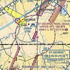
| Sectional chart |
|---|
|
CAUTION: Diagram may not be current

| Airport distance calculator |
|---|
|
|
| Sunrise and sunset |
|---|
|
Times for 06-Jun-2026
| | Local
(UTC-6) | | Zulu
(UTC) |
|---|
| Morning civil twilight | | 05:45 | | 11:45 |
| Sunrise | | 06:15 | | 12:15 |
| Sunset | | 20:50 | | 02:50 |
| Evening civil twilight | | 21:21 | | 03:21 |
|
| Current date and time |
|---|
| Zulu (UTC) | 06-Jun-2026 15:04:41 |
|---|
| Local (UTC-6) | 06-Jun-2026 09:04:41 |
|---|
|
| METAR |
|---|
KSGU
4nm NW | 061456Z AUTO 11008KT 10SM CLR 29/M02 A2980 RMK AO2 SLP048 T02941022 51010
|
|
| TAF |
|---|
KSGU
4nm NW | 061120Z 0612/0712 VRB06KT P6SM SKC FM061800 24020G30KT P6SM SCT200 FM070200 26016KT P6SM BKN180 FM070600 14010KT P6SM BKN180
|
|
| NOTAMs |
|---|
NOTAMs are issued by the DoD/FAA and will open in a separate window not controlled by AirNav.
|
|


