FAA INFORMATION EFFECTIVE 14 MAY 2026
Location
| FAA Identifier: | SUE |
| Lat/Long: | 44-50-37.2000N 087-25-17.5000W
44-50.620000N 087-25.291667W
44.8436667,-87.4215278
(estimated) |
| Elevation: | 724.2 ft. / 220.7 m (surveyed) |
| Variation: | 03W (1995) |
| From city: | 2 miles W of STURGEON BAY, WI |
| Time zone: | UTC -5 (UTC -6 during Standard Time) |
| Zip code: | 54235 |
Airport Operations
| Airport use: | Open to the public |
| Activation date: | 03/1940 |
| Control tower: | no |
| ARTCC: | MINNEAPOLIS CENTER |
| FSS: | GREEN BAY FLIGHT SERVICE STATION |
| NOTAMs facility: | SUE (NOTAM-D service available) |
| Attendance: | MON-SAT 0800-1800, ALL SUN 0800-1600
AFT HRS CALL 920-746-2581. |
| Wind indicator: | lighted |
| Segmented circle: | no |
| Lights: | MIRL RWY 10/28 PRESET TO LOW SS-SR; TO INCR INTST AND ACTVT RLLS RWY 02; REIL RWY 02, 10, 20 & 28; PAPI RWY 02, 10, 20 & 28; MIRL RWY 02/20, MIRL 10/28 - CTAF. |
| Beacon: | white-green (lighted land airport)
Operates sunset to sunrise. |
Airport Communications
| CTAF/UNICOM: | 122.7 |
| WX AWOS-3PT: | 128.325 (920-743-7087) |
| GREEN BAY APPROACH: | 119.25 |
| GREEN BAY DEPARTURE: | 119.25 |
| WX AWOS-3PT at MNM (19 nm NW): | 121.45 (906-863-8801) |
- APCH/DEP SVC PRVDD BY MINNEAPOLIS ARTCC ON 124.4/317.7 (MOSINEE RCAG) WHEN GREEN BAY APCH CLSD.
Nearby radio navigation aids
| VOR radial/distance | | VOR name | | Freq | | Var |
|---|
| GRBr061/37.2 | | GREEN BAY VORTAC | | 115.50 | | 01E |
Airport Services
| Fuel available: | 100LL JET-A+
100LL:24 HR FUEL AVBL WITH CREDIT CARD. |
| Parking: | hangars and tiedowns |
| Airframe service: | MINOR |
| Powerplant service: | MINOR |
Runway Information
Runway 2/20
| Dimensions: | 4599 x 75 ft. / 1402 x 23 m |
| Surface: | asphalt, in fair condition |
| Weight bearing capacity: | | Single wheel: | 16.0 | | Double wheel: | 22.0 |
|
| Runway edge lights: | medium intensity |
| RUNWAY 2 | | RUNWAY 20 |
| Latitude: | 44-50.215523N | | 44-50.953265N |
| Longitude: | 087-25.484965W | | 087-25.247427W |
| Elevation: | 721.6 ft. | | 704.0 ft. |
| Traffic pattern: | left | | left |
| Runway heading: | 016 magnetic, 013 true | | 196 magnetic, 193 true |
| Markings: | nonprecision, in fair condition | | nonprecision, in fair condition |
| Visual slope indicator: | 4-light PAPI on left (3.00 degrees glide path) | | 4-light PAPI on left (3.00 degrees glide path) |
| Approach lights: | RLLS | | |
| Runway end identifier lights: | yes | | yes |
| Touchdown point: | yes, no lights | | yes, no lights |
| Instrument approach: | SDF | | |
Runway 10/28
| Dimensions: | 3199 x 75 ft. / 975 x 23 m |
| Surface: | asphalt, in excellent condition |
| Weight bearing capacity: | | Single wheel: | 16.0 | | Double wheel: | 22.0 |
|
| Runway edge lights: | medium intensity |
| RUNWAY 10 | | RUNWAY 28 |
| Latitude: | 44-50.684535N | | 44-50.656457N |
| Longitude: | 087-25.555852W | | 087-24.817045W |
| Elevation: | 719.2 ft. | | 715.5 ft. |
| Traffic pattern: | left | | left |
| Runway heading: | 096 magnetic, 093 true | | 276 magnetic, 273 true |
| Markings: | nonprecision, in good condition | | nonprecision, in good condition |
| Visual slope indicator: | 4-light PAPI on left (3.00 degrees glide path) | | 4-light PAPI on left (3.00 degrees glide path) |
| Runway end identifier lights: | yes | | yes |
| Touchdown point: | yes, no lights | | yes, no lights |
Airport Ownership and Management from official FAA records
| Ownership: | Publicly-owned |
| Owner: | DOOR COUNTY
COURTHOUSE
STURGEON BAY, WI 54235
Phone 920-743-5511 |
| Manager: | CRAIG ROSS
3538 PARK DR DOOR CO ARPT
STURGEON BAY, WI 54235
Phone 920-746-7131 |
Additional Remarks
| - | BE ALERT: NO LINE OF SIGHT RY 02 TO 20. |
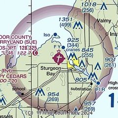
| - | GROUP OF SIX TWRS APRXLY 4 NM NE-TALLEST TWR IS 1351 FT MSL/499 FT AGL. |
| - | WILDLIFE ON & INVOF ARPT. |
| - | ULTRALIGHT ACTIVITY ON & INVOF ARPT. |
| - | FOR CD CTC GREEN BAY APCH ON FREQ OR 920-431-5741, WHEN APCH CLSD, CTC MINNEAPOLIS ARTCC AT 651-463-5588. |
Instrument Procedures
NOTE: All procedures below are presented as PDF files. If you need a reader for these files, you should download the free Adobe Reader.NOT FOR NAVIGATION. Please procure official charts for flight.
FAA instrument procedures published for use from 14 May 2026 at 0901Z to 11 June 2026 at 0900Z.
IAPs - Instrument Approach Procedures |
|---|
| RNAV (GPS) RWY 02 | |
download (207KB) |
| RNAV (GPS) RWY 10 | |
download (202KB) |
| RNAV (GPS) RWY 20 | |
download (212KB) |
| RNAV (GPS) RWY 28 | |
download (201KB) |
| NOTE: Special Alternate Minimums apply | |
download (57KB) |
| NOTE: Special Take-Off Minimums/Departure Procedures apply | |
download (201KB) |
Other nearby airports with instrument procedures:
KMNM - Menominee Regional Airport (19 nm NW)
3D2 - Ephraim/Gibraltar Airport (20 nm NE)
KOCQ - Oconto/J Douglas Bake Municipal Airport (21 nm W)
KGRB - Green Bay/Austin Straubel International Airport (37 nm SW)
2P2 - Washington Island Airport (39 nm NE)
|
|

Road maps at:
MapQuest
Bing
Google
| Aerial photo |
|---|
WARNING: Photo may not be current or correct

Do you have a better or more recent aerial photo of Door County Cherryland Airport that you would like to share? If so, please send us your photo.
|
| Sectional chart |
|---|
|
| Airport distance calculator |
|---|
|
|
| Sunrise and sunset |
|---|
|
Times for 31-May-2026
| | Local
(UTC-5) | | Zulu
(UTC) |
|---|
| Morning civil twilight | | 04:32 | | 09:32 |
| Sunrise | | 05:08 | | 10:08 |
| Sunset | | 20:26 | | 01:26 |
| Evening civil twilight | | 21:02 | | 02:02 |
|
| Current date and time |
|---|
| Zulu (UTC) | 31-May-2026 19:20:39 |
|---|
| Local (UTC-5) | 31-May-2026 14:20:39 |
|---|
|
| METAR |
|---|
| KSUE | 311857Z AUTO 10008KT 10SM CLR 20/07 A3011 RMK AO2 SLP195 T02000072 $
|
KMNM
18nm NW | 311857Z AUTO 12007KT 10SM CLR 21/06 A3010 RMK AO2 SLP192 T02110061 $
|
|
| TAF |
|---|
KGRB
37nm SW | 311724Z 3118/0118 16005KT P6SM SCT250 FM010300 VRB03KT P6SM SCT250 FM011200 07004KT P6SM SCT250
|
KMTW
45nm S | 311724Z 3118/0118 14008KT P6SM SCT250 FM010000 VRB03KT P6SM SCT250 FM011200 06004KT P6SM SCT250
|
|
| NOTAMs |
|---|
NOTAMs are issued by the DoD/FAA and will open in a separate window not controlled by AirNav.
|
|


