FAA INFORMATION EFFECTIVE 09 JULY 2026
Location
| FAA Identifier: | SWW |
| Lat/Long: | 32-28-02.5000N 100-27-59.6000W
32-28.041667N 100-27.993333W
32.4673611,-100.4665556
(estimated) |
| Elevation: | 2379.7 ft. / 725.3 m (surveyed) |
| Variation: | 08E (1990) |
| From city: | 3 miles W of SWEETWATER, TX |
| Time zone: | UTC -5 (UTC -6 during Standard Time) |
| Zip code: | 79556 |
Airport Operations
| Airport use: | Open to the public |
| Activation date: | 12/1946 |
| Control tower: | no |
| ARTCC: | FORT WORTH CENTER |
| FSS: | FORT WORTH FLIGHT SERVICE STATION |
| NOTAMs facility: | SWW (NOTAM-D service available) |
| Attendance: | M-TH 0730-1730, ALL F 0800-1200 |
| Wind indicator: | lighted |
| Segmented circle: | yes |
| Lights: | SS-SR |
| Beacon: | white-green (lighted land airport)
Operates sunset to sunrise. |
Airport Communications
| CTAF/UNICOM: | 122.8 |
| WX AWOS-3: | 119.025 (325-236-9652) |
| ABILENE APPROACH: | 127.2 |
| ABILENE DEPARTURE: | 127.2 |
Nearby radio navigation aids
| VOR radial/distance | | VOR name | | Freq | | Var |
|---|
| ABIr258/30.5 | | ABILENE VORTAC | | 113.70 | | 10E |
| TQAr283/35.7 | | TUSCOLA VOR/DME | | 114.85 | | 10E |
Airport Services
| Fuel available: | 100LL JET-A1+
100LL:FUEL 24 HR SELF SERVE. |
| Parking: | hangars and tiedowns |
| Airframe service: | NONE |
| Powerplant service: | NONE |
Runway Information
Runway 17/35
| Dimensions: | 5840 x 100 ft. / 1780 x 30 m |
| Surface: | asphalt, in good condition |
| Weight bearing capacity: | |
| Runway edge lights: | medium intensity |
| RUNWAY 17 | | RUNWAY 35 |
| Latitude: | 32-28.562762N | | 32-27.605778N |
| Longitude: | 100-28.167825W | | 100-28.042190W |
| Elevation: | 2340.7 ft. | | 2369.0 ft. |
| Traffic pattern: | left | | left |
| Runway heading: | 166 magnetic, 174 true | | 346 magnetic, 354 true |
| Markings: | nonprecision, in good condition | | nonprecision, in good condition |
| Visual slope indicator: | 4-light PAPI on left (3.00 degrees glide path) | | 4-light PAPI on left (3.00 degrees glide path) |
| Runway end identifier lights: | yes | | yes |
| Touchdown point: | yes, no lights | | yes, no lights |
| Obstructions: | 12 ft. trees, 388 ft. from runway, 270 ft. right of centerline, 15:1 slope to clear | | 37 ft. pole, 820 ft. from runway, 325 ft. right of centerline, 16:1 slope to clear |
Runway 4/22
| Dimensions: | 5658 x 75 ft. / 1725 x 23 m |
| Surface: | asphalt, in good condition |
| Weight bearing capacity: | |
| Runway edge lights: | medium intensity |
| RUNWAY 4 | | RUNWAY 22 |
| Latitude: | 32-27.659045N | | 32-28.336608N |
| Longitude: | 100-28.257432W | | 100-27.501038W |
| Elevation: | 2379.5 ft. | | 2336.9 ft. |
| Traffic pattern: | left | | left |
| Runway heading: | 035 magnetic, 043 true | | 215 magnetic, 223 true |
| Markings: | nonprecision, in good condition | | nonprecision, in good condition |
| Visual slope indicator: | 2-light PAPI on left (3.00 degrees glide path) | | 2-light PAPI on left (3.00 degrees glide path) |
| Touchdown point: | yes, no lights | | yes, no lights |
| Obstructions: | 37 ft. trees, 1060 ft. from runway, 300 ft. right of centerline, 23:1 slope to clear | | 35 ft. pole, 555 ft. from runway, 245 ft. right of centerline, 10:1 slope to clear
15 FT GRVL ROAD 199 FT DSTC, 236 FT L. |
Airport Ownership and Management from official FAA records
| Ownership: | Publicly-owned |
| Owner: | CITY OF SWEETWATER
PO BOX 450
SWEETWATER, TX 79556
Phone 325-236-6313 |
| Manager: | LYNN BARRETT
317 HOMER K TAYLOR DR, P.O. BOX 450
SWEETWATER, TX 79556
Phone 325-235-8478 |
Additional Remarks
| - | FOR CD CTC FORT WORTH ARTCC AT 817-858-7584. |
| - | RWY 04/22 & 17/35, ACFT NOT VSB FM OPPOSITE END OF RWY. |
| - | (CONTACT PHONE NR) LENHOBBS122@GMAIL.COM |
Instrument Procedures
NOTE: All procedures below are presented as PDF files. If you need a reader for these files, you should download the free Adobe Reader.NOT FOR NAVIGATION. Please procure official charts for flight.
FAA instrument procedures published for use from 09 July 2026 at 0901Z to 06 August 2026 at 0900Z.
IAPs - Instrument Approach Procedures |
|---|
| RNAV (GPS) RWY 04 **CHANGED** | |
download (244KB) |
| RNAV (GPS) RWY 17 **CHANGED** | |
download (219KB) |
| RNAV (GPS) RWY 22 **CHANGED** | |
download (246KB) |
| RNAV (GPS) RWY 35 **CHANGED** | |
download (277KB) |
| NOTE: Special Alternate Minimums apply | |
download (116KB) |
| NOTE: Special Take-Off Minimums/Departure Procedures apply | |
download (297KB) |
Other nearby airports with instrument procedures:
KSNK - Winston Field Airport (28 nm NW)
KDYS - Dyess Air Force Base (31 nm E)
77F - Winters Municipal Airport (40 nm SE)
KABI - Abilene Regional Airport (40 nm E)
F56 - Arledge Field Airport (46 nm NE)
|
|

Road maps at:
MapQuest
Bing
Google
| Aerial photo |
|---|
WARNING: Photo may not be current or correct

Do you have a better or more recent aerial photo of Avenger Field Airport that you would like to share? If so, please send us your photo.
|
| Sectional chart |
|---|
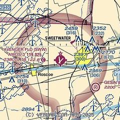
|
| Airport distance calculator |
|---|
|
|
| Sunrise and sunset |
|---|
|
Times for 18-Jul-2026
| | Local
(UTC-5) | | Zulu
(UTC) |
|---|
| Morning civil twilight | | 06:20 | | 11:20 |
| Sunrise | | 06:48 | | 11:48 |
| Sunset | | 20:48 | | 01:48 |
| Evening civil twilight | | 21:16 | | 02:16 |
|
| Current date and time |
|---|
| Zulu (UTC) | 18-Jul-2026 18:31:54 |
|---|
| Local (UTC-5) | 18-Jul-2026 13:31:54 |
|---|
|
| METAR |
|---|
| KSWW | 181815Z AUTO 18010G17KT 10SM 31/20 A3012 RMK AO2 T03080200
|
|
| TAF |
|---|
KDYS
32nm E | 181600Z 1816/1922 19015G25KT 9999 BKN020 QNH2998INS BECMG 1820/1821 18012G18KT 9999 BKN040 QNH2994INS BECMG 1900/1901 17012KT 9999 BKN050 QNH2995INS BECMG 1913/1914 18012G18KT 9999 BKN100 QNH2990INS TX32/1821Z TN23/1912Z
|
KABI
40nm E | 181724Z 1818/1918 19012G22KT P6SM FEW025 SCT250 TEMPO 1818/1820 BKN025 FM182300 16010G20KT P6SM FEW250 FM190300 17010KT P6SM FEW150 SCT250 FM190600 VRB06KT P6SM FEW025 SCT250 FM191400 18010G20KT P6SM FEW250
|
|
| NOTAMs |
|---|
NOTAMs are issued by the DoD/FAA and will open in a separate window not controlled by AirNav.
|
|


