FAA INFORMATION EFFECTIVE 22 JANUARY 2026
Location
| FAA Identifier: | TBR |
| Lat/Long: | 32-28-57.9000N 081-44-13.0000W
32-28.965000N 081-44.216667W
32.4827500,-81.7369444
(estimated) |
| Elevation: | 186.7 ft. / 56.9 m (surveyed) |
| Variation: | 05W (2000) |
| From city: | 3 miles NE of STATESBORO, GA |
| Time zone: | UTC -5 (UTC -4 during Daylight Saving Time) |
| Zip code: | 30461 |
Airport Operations
| Airport use: | Open to the public |
| Activation date: | 04/1940 |
| Control tower: | no |
| ARTCC: | JACKSONVILLE CENTER |
| FSS: | MACON FLIGHT SERVICE STATION |
| NOTAMs facility: | TBR (NOTAM-D service available) |
| Attendance: | MON-FRI 0800-1900, ALL SAT-SUN 0900-1700 |
| Wind indicator: | lighted |
| Segmented circle: | yes |
| Lights: | HIRL RWY 14/32 PRESET ON MED INTST DUSK-2300; TO INCR INTST & ACTVT HIRL AFTER 2300 - CTAF. ACTVT MALSR RWY 32; PAPI RWY 14 & 32 - CTAF. |
| Beacon: | white-green (lighted land airport)
Operates sunset to sunrise. |
Airport Communications
| CTAF/UNICOM: | 122.725 |
| WX AWOS-3: | 119.025 (912-764-9321) |
| SAVANNAH APPROACH: | 118.4 [0600-0000] |
| SAVANNAH DEPARTURE: | 118.4 [0600-0000] |
| WX AWOS-3 at JYL (12 nm NE): | 118.875 (912-857-9000) |
| WX AWOS-3 at CWV (19 nm S): | 120.075 (912-739-3768) |
| WX AWOS-3PT at MHP (19 nm W): | 120.3 (912-685-2729) |
- APCH/DEP SVC PRVDD BY JACKSONVILLE ARTCC ON FREQS 132.925/363.2 (MILLEN RCAG) WHEN SAVANNAH APCH CTL CLSD.
Nearby radio navigation aids
| VOR radial/distance | | VOR name | | Freq | | Var |
|---|
| SAVr313/33.9 | | SAVANNAH VORTAC | | 115.95 | | 06W |
| ALDr216/(38.9) | | ALLENDALE VOR | | 116.70 | | 01W |
| NDB name | | Hdg/Dist | | Freq | | Var | | ID |
|---|
| BULLO | | 323/5.5 | | 407 | | 05W | | BZQ | -... --.. --.- |
| ONYUN | | 067/32.4 | | 372 | | 06W | | UQN | ..- --.- -. |
Airport Services
| Fuel available: | 100LL JET-A+
100LL:24 HR SELF-SERVE FUEL AVBL. |
| Parking: | tiedowns |
| Airframe service: | MAJOR |
| Powerplant service: | MAJOR |
| Bottled oxygen: | NONE |
| Bulk oxygen: | NONE |
Runway Information
Runway 14/32
| Dimensions: | 6000 x 100 ft. / 1829 x 30 m |
| Surface: | asphalt, in excellent condition |
| Weight bearing capacity: | | Single wheel: | 120.0 | | Double wheel: | 211.0 | | Double tandem: | 358.0 | | Dual double tandem: | 851.0 |
|
| Runway edge lights: | high intensity |
| RUNWAY 14 | | RUNWAY 32 |
| Latitude: | 32-29.135558N | | 32-28.435175N |
| Longitude: | 081-44.608187W | | 081-43.783492W |
| Elevation: | 180.8 ft. | | 157.2 ft. |
| Traffic pattern: | left | | left |
| Runway heading: | 140 magnetic, 135 true | | 320 magnetic, 315 true |
| Displaced threshold: | no | | 299 ft. |
| Declared distances: | TORA:6000 TODA:6000 ASDA:6000 LDA:6000 | | TORA:6000 TODA:6000 ASDA:6000 LDA:5701 |
| Markings: | precision, in good condition | | precision, in good condition |
| Visual slope indicator: | 2-light PAPI on left (4.00 degrees glide path) | | 2-light PAPI on left (3.00 degrees glide path) |
| Approach lights: | | | MALSR: 1,400 foot medium intensity approach lighting system with runway alignment indicator lights |
| Touchdown point: | yes, no lights | | yes, no lights |
| Instrument approach: | | | ILS |
| Obstructions: | 72 ft. trees, 1793 ft. from runway, 637 ft. left of centerline, 22:1 slope to clear | | 15 ft. road, 380 ft. from runway, 540 ft. right of centerline, 12:1 slope to clear
APPROACH SLOPE TO DSPLCD THLD IS 30:1; TREES 570FT FROM DSPLCD THLD 288FT LEFT. |
Runway 6/24
| Dimensions: | 4382 x 100 ft. / 1336 x 30 m |
| Surface: | asphalt, in good condition |
| Weight bearing capacity: | | Single wheel: | 73.0 | | Double wheel: | 105.0 | | Double tandem: | 172.0 |
|
| RUNWAY 6 | | RUNWAY 24 |
| Latitude: | 32-28.975000N | | 32-29.443642N |
| Longitude: | 081-44.569180W | | 081-43.920072W |
| Elevation: | 177.8 ft. | | 186.7 ft. |
| Traffic pattern: | left | | left |
| Runway heading: | 055 magnetic, 050 true | | 235 magnetic, 230 true |
| Markings: | basic, in good condition | | basic, in good condition |
| Touchdown point: | yes, no lights | | yes, no lights |
| Obstructions: | 78 ft. trees, 1729 ft. from runway, 385 ft. left of centerline, 19:1 slope to clear | | 72 ft. trees, 1126 ft. from runway, 300 ft. right of centerline, 12:1 slope to clear |
Airport Ownership and Management from official FAA records
| Ownership: | Publicly-owned |
| Owner: | STATESBORO CITY & BULLOCH COUNTY
115 NORTH MAIN STREET
STATESBORO, GA 30458
Phone 912-764-5468 |
| Manager: | DAVID CAMPBELL
601 AIRPORT BLVD
STATESBORO, GA 30461
Phone 912-764-9083 |
Additional Remarks
| A39-06/24 | PCR VALUE: 285/F/C/X/T |
| A39-14/32 | PCR VALUE: 522/F/B/X/T |
| - | BIRDS & DEER ON & INVOF ARPT. |
| - | FOR CD CTC SAVANNAH APCH AT 912-964-3205, WHEN APCH CLSD CTC JACKSONVILLE ARTCC AT 904-845-1592. |
Instrument Procedures
NOTE: All procedures below are presented as PDF files. If you need a reader for these files, you should download the free Adobe Reader.NOT FOR NAVIGATION. Please procure official charts for flight.
FAA instrument procedures published for use from 22 January 2026 at 0901Z to 19 February 2026 at 0900z.
IAPs - Instrument Approach Procedures |
|---|
| ILS OR LOC RWY 32 | |
download (237KB) |
| RNAV (GPS) RWY 14 | |
download (246KB) |
| RNAV (GPS) RWY 32 | |
download (260KB) |
| NOTE: Special Alternate Minimums apply | |
download (158KB) |
| NOTE: Special Take-Off Minimums/Departure Procedures apply | |
download (512KB) |
Other nearby airports with instrument procedures:
KJYL - Plantation Airpark (12 nm NE)
KCWV - Claxton-Evans County Airport (19 nm S)
KMHP - John Edwin Jones Sr Field/Metter Municipal Airport (19 nm W)
2J5 - Millen Airport (27 nm NW)
KSBO - East Georgia Regional Airport (33 nm W)
|
|

Road maps at:
MapQuest
Bing
Google
| Aerial photo |
|---|
WARNING: Photo may not be current or correct
 Photo by Joe Pelton
Photo taken 25-Nov-2006
Photo by Joe Pelton
Photo taken 25-Nov-2006
Do you have a better or more recent aerial photo of Statesboro-Bulloch County Airport that you would like to share? If so, please send us your photo.
|
| Sectional chart |
|---|
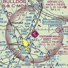
|
| Airport distance calculator |
|---|
|
|
| Sunrise and sunset |
|---|
|
Times for 27-Jan-2026
| | Local
(UTC-5) | | Zulu
(UTC) |
|---|
| Morning civil twilight | | 06:59 | | 11:59 |
| Sunrise | | 07:25 | | 12:25 |
| Sunset | | 17:54 | | 22:54 |
| Evening civil twilight | | 18:20 | | 23:20 |
|
| Current date and time |
|---|
| Zulu (UTC) | 27-Jan-2026 07:05:03 |
|---|
| Local (UTC-5) | 27-Jan-2026 02:05:03 |
|---|
|
| METAR |
|---|
| KTBR | 270655Z AUTO 33006KT 10SM CLR M03/M15 A3039 RMK AO2
|
KJYL
12nm NE | 270655Z AUTO 35007KT 10SM M04/M13 A3041 RMK AO2 T10401132
|
KCWV
19nm S | 270655Z AUTO 31005KT 10SM CLR M02/M13 A3042 RMK AO2
|
KMHP
19nm W | 270655Z AUTO 33008KT 10SM CLR M03/M15 A3042 RMK AO2 T10291153
|
|
| TAF |
|---|
KSAV
35nm SE | 270528Z 2706/2806 31010G18KT P6SM SKC FM270900 33005KT P6SM SKC FM271700 27009KT P6SM SKC
|
KSVN
41nm SE | 270100Z 2701/2807 31012KT 9999 SKC QNH3024INS BECMG 2710/2711 30009KT 9999 SKC QNH3029INS BECMG 2803/2804 27006KT 9999 SCT200 QNH3025INS TX08/2721Z TNM06/2710Z
|
|
| NOTAMs |
|---|
NOTAMs are issued by the DoD/FAA and will open in a separate window not controlled by AirNav.
|
|


