FAA INFORMATION EFFECTIVE 27 NOVEMBER 2025
Location
| FAA Identifier: | TPH |
| Lat/Long: | 38-03-35.6170N 117-05-11.7630W
38-03.593617N 117-05.196050W
38.0598936,-117.0866008
(estimated) |
| Elevation: | 5430.3 ft. / 1655.2 m (surveyed) |
| Variation: | 15E (1995) |
| From city: | 7 miles E of TONOPAH, NV |
| Time zone: | UTC -8 (UTC -7 during Daylight Saving Time) |
| Zip code: | 89049 |
Airport Operations
| Airport use: | Open to the public |
| Activation date: | 09/1944 |
| Control tower: | no |
| ARTCC: | LOS ANGELES CENTER |
| FSS: | RENO FLIGHT SERVICE STATION |
| NOTAMs facility: | TPH (NOTAM-D service available) |
| Attendance: | 0600-2300 |
| Wind indicator: | lighted |
| Segmented circle: | yes |
| Lights: | ACTVT PAPI RWY 15; MIRL RWY 15/33 & 11/29 - CTAF. |
| Beacon: | white-green (lighted land airport)
Operates sunset to sunrise. |
Airport Communications
| CTAF/UNICOM: | 123.0 |
| WX ASOS: | 118.875 (775-482-3441) |
Nearby radio navigation aids
| VOR radial/distance | | VOR name | | Freq | | Var |
|---|
| TPHr288/3.1 | | TONOPAH VORTAC | | 116.00 | | 17E |
| TQQr302/21.7 | | SILVERBOW VORTAC | | 113.00 | | 16E |
| OALr067/32.5 | | COALDALE VORTAC | | 117.70 | | 17E |
Airport Services
| Fuel available: | 100LL JET-A
100LL:FUEL AVBL 0700-1800; AFT HRS O/R CALL (775) 482-3626. |
| Parking: | buoy and tiedowns |
| Airframe service: | MAJOR |
| Powerplant service: | MAJOR |
| Bottled oxygen: | LOW |
| Bulk oxygen: | NONE |
Runway Information
Runway 15/33
| Dimensions: | 7160 x 75 ft. / 2182 x 23 m |
| Surface: | asphalt, in excellent condition |
| Weight bearing capacity: | |
| Runway edge lights: | medium intensity |
| RUNWAY 15 | | RUNWAY 33 |
| Latitude: | 38-04.051945N | | 38-02.912868N |
| Longitude: | 117-05.563247W | | 117-05.176612W |
| Elevation: | 5430.2 ft. | | 5396.0 ft. |
| Traffic pattern: | left | | left |
| Runway heading: | 150 magnetic, 165 true | | 330 magnetic, 345 true |
| Markings: | nonprecision, in good condition | | nonprecision, in good condition |
| Visual slope indicator: | 2-light PAPI on left (3.00 degrees glide path) | | |
| Runway end identifier lights: | no | | no |
| Touchdown point: | yes, no lights | | yes, no lights |
Runway 11/29
| Dimensions: | 5660 x 50 ft. / 1725 x 15 m |
| Surface: | asphalt/L
RWY CRACKING FULL-LEN; LATERAL & LONGL CRACKS IN EXCESS OF 4 INCHES. |
| Weight bearing capacity: | | Single wheel: | 30.0 | | Double wheel: | 66.0 | | Double tandem: | 77.0 |
|
| Runway edge lights: | medium intensity |
| RUNWAY 11 | | RUNWAY 29 |
| Latitude: | 38-04.001357N | | 38-03.467273N |
| Longitude: | 117-05.459017W | | 117-04.493095W |
| Elevation: | 5428.4 ft. | | 5410.4 ft. |
| Traffic pattern: | left | | left |
| Runway heading: | 110 magnetic, 125 true | | 290 magnetic, 305 true |
| Markings: | basic, in fair condition | | basic, in fair condition |
| Runway end identifier lights: | no | | no |
| Touchdown point: | yes, no lights | | yes, no lights |
Helipad H1
| Dimensions: | 48 x 48 ft. / 15 x 15 m |
| Surface: | asphalt/aggregate friction seal coat, in good condition |
| Runway edge markings: | FATO & "H" MARKED IN YELLOW
FADED YELLOW OUTLINE. |
| Latitude: | 38-03.758473N | | |
| Longitude: | 117-05.679145W | | |
| Elevation: | 5420.1 ft. | | |
| Traffic pattern: | left | | left |
| Markings: | NSTD, in good condition | | |
Airport Ownership and Management from official FAA records
| Ownership: | Publicly-owned |
| Owner: | NYE COUNTY
P O BOX 1031
TONOPAH, NV 89049
Phone (775) 209-4174
OTR CTC (775) 482-3626. |
| Manager: | THOMAS BOLLING
2041 E. CALVADA BLVD. N. SUITE #3
PAHRUMP, NV 89048
Phone 775-751-6270 |
Additional Remarks
| - | FOR CD, IF UNA TO CTC ON FSS FREQ, CTC NELLIS APCH AT 702-652-4172. |
Instrument Procedures
NOTE: All procedures below are presented as PDF files. If you need a reader for these files, you should download the free Adobe Reader.NOT FOR NAVIGATION. Please procure official charts for flight.
FAA instrument procedures published for use from 27 November 2025 at 0901Z to 25 December 2025 at 0900Z.
IAPs - Instrument Approach Procedures |
|---|
| RNAV (GPS) RWY 15 | |
download (187KB) |
| VOR-A | |
download (188KB) |
| NOTE: Special Alternate Minimums apply | |
download (143KB) |
| NOTE: Special Take-Off Minimums/Departure Procedures apply | |
download (540KB) |
Other nearby airports with instrument procedures:
KTNX - Tonopah Test Range Airport (21 nm SE)
KBIH - Bishop Airport (73 nm SW)
KHTH - Hawthorne Industrial Airport (78 nm W)
KMMH - Mammoth Yosemite Airport (87 nm W)
|
|

Road maps at:
MapQuest
Bing
Google
| Aerial photo |
|---|
WARNING: Photo may not be current or correct

Do you have a better or more recent aerial photo of Tonopah Airport that you would like to share? If so, please send us your photo.
|
| Sectional chart |
|---|
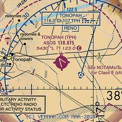
|
 Download PDF
of official airport diagram from the FAA
| Airport distance calculator |
|---|
|
|
| Sunrise and sunset |
|---|
|
Times for 06-Dec-2025
| | Local
(UTC-8) | | Zulu
(UTC) |
|---|
| Morning civil twilight | | 06:22 | | 14:22 |
| Sunrise | | 06:51 | | 14:51 |
| Sunset | | 16:27 | | 00:27 |
| Evening civil twilight | | 16:57 | | 00:57 |
|
| Current date and time |
|---|
| Zulu (UTC) | 07-Dec-2025 06:36:23 |
|---|
| Local (UTC-8) | 06-Dec-2025 22:36:23 |
|---|
|
| METAR |
|---|
| KTPH | 070556Z AUTO 35005KT 10SM CLR 06/M03 A3023 RMK AO2 SLP214 T00611033 10122 20050 51013
|
|
| TAF |
|---|
| KTPH | 070520Z 0706/0806 35008KT P6SM FEW110 FM072100 27004KT P6SM SCT200
|
|
| NOTAMs |
|---|
NOTAMs are issued by the DoD/FAA and will open in a separate window not controlled by AirNav.
|
|


