FAA INFORMATION EFFECTIVE 09 JULY 2026
Location
| FAA Identifier: | ULM |
| Lat/Long: | 44-19-06.1920N 094-30-05.9160W
44-19.103200N 094-30.098600W
44.3183867,-94.5016433
(estimated) |
| Elevation: | 1011.2 ft. / 308.2 m (surveyed) |
| Variation: | 01E (2015) |
| From city: | 2 miles W of NEW ULM, MN |
| Time zone: | UTC -5 (UTC -6 during Standard Time) |
| Zip code: | 56073 |
Airport Operations
| Airport use: | Open to the public |
| Activation date: | 09/1945 |
| Control tower: | no |
| ARTCC: | MINNEAPOLIS CENTER |
| FSS: | PRINCETON FLIGHT SERVICE STATION |
| NOTAMs facility: | ULM (NOTAM-D service available) |
| Attendance: | MON-FRI 0800-1700 |
| Wind indicator: | lighted |
| Segmented circle: | no |
| Lights: | ACTVT MALSF RWY 33; REIL RWY 15; PAPI RWY 15 & 33; MIRL RWY 15/33 - CTAF. |
| Beacon: | white-green (lighted land airport)
Operates sunset to sunrise. |
Airport Communications
| CTAF/UNICOM: | 123.0 |
| WX AWOS-3: | 118.325 (507-359-1656) |
- APCH/DEP SVC PRVDD BY MINNEAPOLIS ARTCC ON FREQS 127.1/290.2 (REDWOOD FALLS RCAG).
Nearby radio navigation aids
| VOR radial/distance | | VOR name | | Freq | | Var |
|---|
| RWFr101/28.3 | | REDWOOD FALLS VOR/DME | | 113.30 | | 07E |
Airport Services
| Fuel available: | 100LL JET-A
100LL:FUEL AVBL H24 VIA CREDIT CARD. |
| Parking: | hangars and tiedowns |
| Airframe service: | MAJOR |
| Powerplant service: | MAJOR |
| Bottled oxygen: | NONE |
| Bulk oxygen: | NONE |
Runway Information
Runway 15/33
| Dimensions: | 5401 x 100 ft. / 1646 x 30 m |
| Surface: | asphalt/grooved, in good condition |
| Runway edge lights: | medium intensity |
| RUNWAY 15 | | RUNWAY 33 |
| Latitude: | 44-19.443452N | | 44-18.667767N |
| Longitude: | 094-30.384995W | | 094-29.780363W |
| Elevation: | 1005.0 ft. | | 1003.2 ft. |
| Traffic pattern: | left | | left |
| Runway heading: | 150 magnetic, 151 true | | 330 magnetic, 331 true |
| Markings: | nonprecision, in good condition | | nonprecision, in good condition |
| Visual slope indicator: | 4-light PAPI on left (3.00 degrees glide path) | | 4-light PAPI on right (3.00 degrees glide path) |
| Approach lights: | | | MALSF: 1,400 foot medium intensity approach lighting system with sequenced flashers |
| Runway end identifier lights: | yes | | no |
| Touchdown point: | yes, no lights | | yes, no lights |
Runway 4/22
| Dimensions: | 2478 x 160 ft. / 755 x 49 m |
| Surface: | turf, in good condition |
| Runway edge markings: | YELLOW CONES. |
| Operational restrictions: | CLSD WINTER MONTHS. |
| RUNWAY 4 | | RUNWAY 22 |
| Latitude: | 44-19.072803N | | 44-19.341167N |
| Longitude: | 094-30.346997W | | 094-29.919833W |
| Elevation: | 1003.4 ft. | | 1001.2 ft. |
| Traffic pattern: | left | | left |
| Runway heading: | 048 magnetic, 049 true | | 228 magnetic, 229 true |
| Runway end identifier lights: | no | | no |
| Touchdown point: | yes, no lights | | yes, no lights |
Airport Ownership and Management from official FAA records
| Ownership: | Publicly-owned |
| Owner: | CITY OF NEW ULM
100 N BROADWAY, PO BOX 636
NEW ULM, MN 56073-1795
Phone 507-359-8245 |
| Manager: | JOSEPH STADHEIM
100 N BROADWAY ST
NEW ULM, MN 56073-1795
Phone 507-233-2118
OR 507-354-8127. |
Additional Remarks
| - | GCO AVBL ON FREQ 121.725 THRU MINNEAPOLIS ARTCC & FLT SVCS. |
| - | FOR CD IF UNA VIA GCO CTC MINNEAPOLIS ARTCC AT 651-463-5588. |
Instrument Procedures
NOTE: All procedures below are presented as PDF files. If you need a reader for these files, you should download the free Adobe Reader.NOT FOR NAVIGATION. Please procure official charts for flight.
FAA instrument procedures published for use from 09 July 2026 at 0901Z to 06 August 2026 at 0900Z.
IAPs - Instrument Approach Procedures |
|---|
| RNAV (GPS) RWY 15 | |
download (218KB) |
| RNAV (GPS) RWY 33 | |
download (231KB) |
| NOTE: Special Take-Off Minimums/Departure Procedures apply | |
download (228KB) |
Other nearby airports with instrument procedures:
KJYG - St James Municipal Airport (20 nm S)
D42 - Springfield Municipal Airport (22 nm W)
KMKT - Mankato Regional Airport (26 nm E)
KRWF - Redwood Falls Municipal Airport (28 nm NW)
KGYL - Glencoe Municipal Airport (32 nm NE)
|
|

Road maps at:
MapQuest
Bing
Google
| Aerial photo |
|---|
WARNING: Photo may not be current or correct
 Photo taken 09-Jul-2017
looking southeast.
Photo taken 09-Jul-2017
looking southeast.
Do you have a better or more recent aerial photo of New Ulm Municipal Airport that you would like to share? If so, please send us your photo.
|
| Sectional chart |
|---|
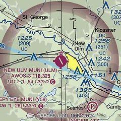
|
| Airport distance calculator |
|---|
|
|
| Sunrise and sunset |
|---|
|
Times for 20-Jul-2026
| | Local
(UTC-5) | | Zulu
(UTC) |
|---|
| Morning civil twilight | | 05:19 | | 10:19 |
| Sunrise | | 05:54 | | 10:54 |
| Sunset | | 20:55 | | 01:55 |
| Evening civil twilight | | 21:30 | | 02:30 |
|
| Current date and time |
|---|
| Zulu (UTC) | 20-Jul-2026 17:55:56 |
|---|
| Local (UTC-5) | 20-Jul-2026 12:55:56 |
|---|
|
| METAR |
|---|
| KULM | 201735Z AUTO 26011KT 10SM -TSDZ CLR 29/26 A2978 RMK AO2 LTG DSNT E TH
|
|
| TAF |
|---|
KMKT
26nm E | 201120Z 2012/2112 18010KT P6SM BKN080 TEMPO 2012/2013 5SM -TSRA BKN050CB FM201500 23012KT P6SM BKN100 FM201900 28012G20KT P6SM FEW150 FM210100 31011KT P6SM SKC
|
KRWF
29nm NW | 201120Z 2012/2112 19010KT P6SM SCT100 FM201500 26010KT P6SM FEW100 FM201800 30014G25KT P6SM SKC FM210100 32012G18KT P6SM SKC FM210300 32012KT 6SM FU FEW250
|
|
| NOTAMs |
|---|
NOTAMs are issued by the DoD/FAA and will open in a separate window not controlled by AirNav.
|
|

