FAA INFORMATION EFFECTIVE 21 MARCH 2024
Location
| FAA Identifier: | VES |
| Lat/Long: | 40-12-15.8790N 084-31-56.7220W
40-12.264650N 084-31.945367W
40.2044108,-84.5324228
(estimated) |
| Elevation: | 1007 ft. / 306.9 m (surveyed) |
| Variation: | 04W (1985) |
| From city: | 2 miles SW of VERSAILLES, OH |
| Time zone: | UTC -4 (UTC -5 during Standard Time) |
| Zip code: | 45380 |
Airport Operations
| Airport use: | Open to the public |
| Activation date: | 06/1964 |
| Control tower: | no |
| ARTCC: | INDIANAPOLIS CENTER |
| FSS: | DAYTON FLIGHT SERVICE STATION |
| NOTAMs facility: | DAY (NOTAM-D service available) |
| Attendance: | MON-FRI 0800-1630 |
| Wind indicator: | lighted |
| Segmented circle: | no |
| Lights: | ACTVT REIL RWY 09 & 27; MIRL RWY 09/27 - CTAF. PAPI RWY 09 & 27 OPR CONSLY. |
| Beacon: | white-green (lighted land airport)
Operates sunset to sunrise. |
Airport Communications
| CTAF/UNICOM: | 122.8 |
| WX AWOS-3T: | 125.9 (937-526-3154) |
| COLUMBUS APPROACH: | 118.425 |
| COLUMBUS DEPARTURE: | 118.425 |
| CLASS C: | 118.425 |
| IC: | 118.425 |
| WX AWOS-3 at SCA (18 nm E): | 120.425 (937-492-3683) |
Nearby radio navigation aids
| VOR radial/distance | | VOR name | | Freq | | Var |
|---|
| DQNr332/12.9 | | DAYTON VOR/DME | | 114.50 | | 01W |
| RODr262/23.0 | | ROSEWOOD VORTAC | | 117.50 | | 05W |
| MIEr096/39.5 | | MUNCIE VOR/DME | | 114.40 | | 03W |
Airport Services
| Fuel available: | 100LL JET-A+
100LL:100LL & JET A+ AVBL H24 VIA CREDIT CARD. |
| Parking: | hangars and tiedowns |
| Airframe service: | NONE |
| Powerplant service: | NONE |
| Bottled oxygen: | NONE |
| Bulk oxygen: | NONE |
Runway Information
Runway 9/27
| Dimensions: | 4802 x 75 ft. / 1464 x 23 m |
| Surface: | asphalt, in good condition |
| Weight bearing capacity: | |
| Runway edge lights: | medium intensity |
| RUNWAY 9 | | RUNWAY 27 |
| Latitude: | 40-12.254540N | | 40-12.274708N |
| Longitude: | 084-32.460865W | | 084-31.429852W |
| Elevation: | 1004.8 ft. | | 1004.0 ft. |
| Traffic pattern: | left | | left |
| Runway heading: | 093 magnetic, 089 true | | 273 magnetic, 269 true |
| Markings: | nonprecision, in good condition | | nonprecision, in good condition |
| Visual slope indicator: | 2-light PAPI on left (3.00 degrees glide path) | | 2-light PAPI on left (3.00 degrees glide path) |
| Runway end identifier lights: | yes | | yes |
| Touchdown point: | yes, no lights | | yes, no lights |
| Obstructions: | none | | 11 ft. crops, 201 ft. from runway, 105 ft. left of centerline
+6-14 FT ACFT PRKG, 0-200 FT DIST, 150 FT R; +11 FT CROPS, 0-200 FT DIST, 105 FT L. |
Airport Ownership and Management from official FAA records
| Ownership: | Publicly-owned |
| Owner: | DARKE CO COMMISSIONERS
DARKE CO COURTHOUSE
GREENVILLE, OH 45331-1993 |
| Manager: | SCOTT NAAS
9724 STATE ROUTE 121
VERSAILLES, OH 45380-9513
Phone 937-467-9360
SNAAS@CO.DARKE.OH.US. |
Airport Operational Statistics
| Aircraft based on the field: | | 29 | | Single engine airplanes: | | 25 | | Multi engine airplanes: | | 2 | | Jet airplanes: | | 1 | | Helicopters: | | 1 |
| |  | |
| Aircraft operations: avg 35/day * | | 62% | local general aviation | | 23% | transient general aviation | | 15% | air taxi | | <1% | military | | * for 12-month period ending 29 September 2021 | |
Additional Remarks
| - | OCNL DEER, BIRDS, & OTR WILDLIFE ON & INVOF ARPT. |
| - | FOR CD CTC COLUMBUS APCH AT 614-338-8537. |
Instrument Procedures
NOTE: All procedures below are presented as PDF files. If you need a reader for these files, you should download the free Adobe Reader.NOT FOR NAVIGATION. Please procure official charts for flight.
FAA instrument procedures published for use from 21 March 2024 at 0901Z to 18 April 2024 at 0900z.
IAPs - Instrument Approach Procedures |
|---|
| RNAV (GPS) RWY 09 | |
download (238KB) |
| RNAV (GPS) RWY 27 | |
download (208KB) |
| NOTE: Special Take-Off Minimums/Departure Procedures apply | |
download (164KB) |
Other nearby airports with instrument procedures:
I17 - Piqua Airport/Hartzell Field (11 nm E)
KCQA - Lakefield Airport (17 nm N)
KSCA - Sidney Municipal Airport (18 nm E)
I22 - Randolph County Airport (18 nm W)
3I7 - Dayton/Phillipsburg Airport (18 nm S)
|
|

Road maps at:
MapQuest
Bing
Google
| Aerial photo |
|---|
WARNING: Photo may not be current or correct
 Photo by Rick Hunt
Photo taken 10-Nov-2012
Photo by Rick Hunt
Photo taken 10-Nov-2012
Do you have a better or more recent aerial photo of Darke County Airport that you would like to share? If so, please send us your photo.
|
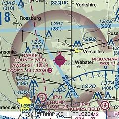
| Sectional chart |
|---|
|
| Airport distance calculator |
|---|
|
|
| Sunrise and sunset |
|---|
|
Times for 18-Apr-2024
| | Local
(UTC-4) | | Zulu
(UTC) |
|---|
| Morning civil twilight | | 06:27 | | 10:27 |
| Sunrise | | 06:55 | | 10:55 |
| Sunset | | 20:20 | | 00:20 |
| Evening civil twilight | | 20:48 | | 00:48 |
|
| Current date and time |
|---|
| Zulu (UTC) | 18-Apr-2024 12:27:41 |
|---|
| Local (UTC-4) | 18-Apr-2024 08:27:41 |
|---|
|
| METAR |
|---|
| KVES | 181210Z AUTO 30005KT 10SM CLR 10/07 A3007 RMK AO2
|
|
| TAF |
|---|
KDAY
23nm SE | 181133Z 1812/1912 29005KT P6SM SKC FM181500 VRB04KT P6SM SKC FM181800 21004KT P6SM SCT250 FM190000 14007KT P6SM SCT250 FM190500 18012KT 6SM -SHRA OVC050 FM190900 22012G18KT 6SM -SHRA BR OVC015 FM191100 27012G18KT P6SM VCSH OVC012
|
|
| NOTAMs |
|---|
NOTAMs are issued by the DoD/FAA and will open in a separate window not controlled by AirNav.
|
|
