FAA INFORMATION EFFECTIVE 22 JANUARY 2026
Location
| FAA Identifier: | VHN |
| Lat/Long: | 31-03-28.2000N 104-47-01.7000W
31-03.470000N 104-47.028333W
31.0578333,-104.7838056
(estimated) |
| Elevation: | 3956.8 ft. / 1206.0 m (surveyed) |
| Variation: | 10E (1990) |
| From city: | 3 miles NE of VAN HORN, TX |
| Time zone: | UTC -6 (UTC -5 during Daylight Saving Time) |
| Zip code: | 79855 |
Airport Operations
| Airport use: | Open to the public |
| Activation date: | 11/1943 |
| Control tower: | no |
| ARTCC: | ALBUQUERQUE CENTER |
| FSS: | ALBUQUERQUE FLIGHT SERVICE STATION |
| NOTAMs facility: | ABQ (NOTAM-D service available) |
| Attendance: | 0900-1800 |
| Wind indicator: | lighted |
| Segmented circle: | yes |
| Lights: | ACTVT PAPI RWY 03 & 21; MIRL RWY 03/21 & RWY 07/25 - CTAF. |
| Beacon: | white-green (lighted land airport)
Operates sunset to sunrise. |
Airport Communications
| CTAF: | 122.9 |
| WX AWOS-3PT: | 119.925 (432-283-2418) |
- APCH/DEP SVC PRVDD BY ALBUQUERQUE ARTCC (ABQ) ON FREQS 135.875/292.15 (EL PASO/A/ RCAG).
Nearby radio navigation aids
| NDB name | | Hdg/Dist | | Freq | | Var | | ID |
|---|
| KENT | | 268/29.8 | | 225 | | 07E | | XAA | -..- .- .- |
Airport Services
| Fuel available: | 100LL JET-A1+
100LL:FOR FUEL CALL 432-283-2237 OR 432-284-1418. |
| Parking: | tiedowns |
| Bottled oxygen: | NONE |
| Bulk oxygen: | NONE |
Runway Information
Runway 3/21
| Dimensions: | 6005 x 76 ft. / 1830 x 23 m |
| Surface: | asphalt, in good condition |
| Weight bearing capacity: | |
| Runway edge lights: | medium intensity |
| RUNWAY 3 | | RUNWAY 21 |
| Latitude: | 31-03.250655N | | 31-03.956910N |
| Longitude: | 104-47.475788W | | 104-46.669300W |
| Elevation: | 3956.0 ft. | | 3918.3 ft. |
| Traffic pattern: | left | | left |
| Runway heading: | 035 magnetic, 045 true | | 215 magnetic, 225 true |
| Markings: | nonprecision, in good condition | | nonprecision, in good condition |
| Visual slope indicator: | 2-light PAPI on left (3.00 degrees glide path) | | 2-light PAPI on left (3.00 degrees glide path) |
| Touchdown point: | yes, no lights | | yes, no lights |
| Obstructions: | 10 ft. brush, 270 ft. from runway, 250 ft. left of centerline, 7:1 slope to clear
10 FT BRUSH, 30 FT DSTC, 250 FT L. | | 12 ft. brush, 258 ft. from runway, 130 ft. right of centerline, 4:1 slope to clear
10 FT BRUSH, 0-200 FT DSTC. |
Runway 7/25
| Dimensions: | 5353 x 75 ft. / 1632 x 23 m |
| Surface: | asphalt, in good condition |
| Weight bearing capacity: | |
| Runway edge lights: | medium intensity |
| RUNWAY 7 | | RUNWAY 25 |
| Latitude: | 31-03.276832N | | 31-03.362692N |
| Longitude: | 104-47.489360W | | 104-46.468765W |
| Elevation: | 3956.8 ft. | | 3910.7 ft. |
| Traffic pattern: | left | | left |
| Runway heading: | 074 magnetic, 084 true | | 254 magnetic, 264 true |
| Markings: | basic, in fair condition | | basic, in fair condition |
| Touchdown point: | yes, no lights | | yes, no lights |
| Obstructions: | 15 ft. brush, 276 ft. from runway, 125 ft. left and right of centerline, 5:1 slope to clear | | none |
Airport Ownership and Management from official FAA records
| Ownership: | Publicly-owned |
| Owner: | CULBERSON COUNTY
501 W. BROADWAY, PO BOX 927
VAN HORN, TX 79855
Phone 915-283-2058 |
| Manager: | JUDGE CARLOS URIAS
501 W. BROADWAY, BOX 927
VAN HORN, TX 79855
Phone 432-283-2059 |
Additional Remarks
| - | FOR CD CTC ALBUQUERQUE ARTCC AT 505-856-4861. |
Instrument Procedures
NOTE: All procedures below are presented as PDF files. If you need a reader for these files, you should download the free Adobe Reader.NOT FOR NAVIGATION. Please procure official charts for flight.
FAA instrument procedures published for use from 22 January 2026 at 0901Z to 19 February 2026 at 0900z.
IAPs - Instrument Approach Procedures |
|---|
| RNAV (GPS) RWY 21 | |
download (213KB) |
| NOTE: Special Alternate Minimums apply | |
download (116KB) |
| NOTE: Special Take-Off Minimums/Departure Procedures apply | |
download (303KB) |
Other nearby airports with instrument procedures:
KMRF - Marfa Municipal Airport (57 nm SE)
KPEQ - Pecos Municipal Airport (68 nm E)
E38 - Alpine-Casparis Municipal Airport (70 nm SE)
KCNM - Cavern City Air Terminal (81 nm N)
KPRS - Presidio Lely International Airport (88 nm S)
|
|

Road maps at:
MapQuest
Bing
Google
| Aerial photo |
|---|
WARNING: Photo may not be current or correct

Do you have a better or more recent aerial photo of Culberson County Airport that you would like to share? If so, please send us your photo.
|
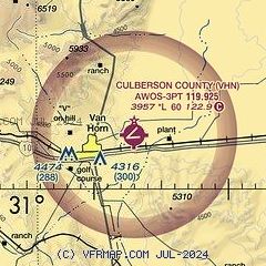
| Sectional chart |
|---|
|
| Airport distance calculator |
|---|
|
|
| Sunrise and sunset |
|---|
|
Times for 18-Feb-2026
| | Local
(UTC-6) | | Zulu
(UTC) |
|---|
| Morning civil twilight | | 07:14 | | 13:14 |
| Sunrise | | 07:38 | | 13:38 |
| Sunset | | 18:48 | | 00:48 |
| Evening civil twilight | | 19:13 | | 01:13 |
|
| Current date and time |
|---|
| Zulu (UTC) | 18-Feb-2026 09:01:41 |
|---|
| Local (UTC-6) | 18-Feb-2026 03:01:41 |
|---|
|
| METAR |
|---|
| KVHN | 180855Z AUTO 26009KT 10SM CLR 10/M01 A3006 RMK AO2 T01031006
|
|
| NOTAMs |
|---|
NOTAMs are issued by the DoD/FAA and will open in a separate window not controlled by AirNav.
|
|


