FAA INFORMATION EFFECTIVE 25 DECEMBER 2025
Location
| FAA Identifier: | WRL |
| Lat/Long: | 43-57-46.4000N 107-57-01.9000W
43-57.773333N 107-57.031667W
43.9628889,-107.9505278
(estimated) |
| Elevation: | 4251.7 ft. / 1295.9 m (surveyed) |
| Variation: | 13E (1995) |
| From city: | 3 miles S of WORLAND, WY |
| Time zone: | UTC -7 (UTC -6 during Daylight Saving Time) |
| Zip code: | 82401 |
Airport Operations
| Airport use: | Open to the public |
| Activation date: | 01/1945 |
| Control tower: | no |
| ARTCC: | SALT LAKE CITY CENTER |
| FSS: | CASPER FLIGHT SERVICE STATION |
| NOTAMs facility: | WRL (NOTAM-D service available) |
| Attendance: | MON-FRI 0700-1600 |
| Wind indicator: | lighted |
| Segmented circle: | yes |
| Lights: | ACTVT REIL RWY 16 & 34; PAPI RWY 34; MIRL RWY 16/34 - CTAF. PAPI RWY 16 OPR CONSLY. |
| Beacon: | white-green (lighted land airport)
Operates sunset to sunrise. |
Airport Communications
| CTAF/UNICOM: | 123.05 |
| WX ASOS: | 135.475 (307-347-4217) |
- APCH/DEP CTL SVC PRVDD BY SALT LAKE ARTCC (ZLC) ON FREQS 133.25/285.6 (BOYSEN RCAG).
Nearby radio navigation aids
| VOR radial/distance | | VOR name | | Freq | | Var |
|---|
| RLY at field | | WORLAND VOR/DME | | 114.80 | | 13E |
| BOYr011/33.6 | | BOYSEN RESERVOIR VOR/DME | | 117.80 | | 16E |
Airport Services
| Fuel available: | 100LL JET-A
100LL:FUEL AVBL VIA 24 HR SELF SERVE CREDIT CARD. |
| Parking: | hangars and tiedowns |
| Airframe service: | NONE |
| Powerplant service: | NONE |
| Bottled oxygen: | NONE |
| Bulk oxygen: | NONE |
Runway Information
Runway 16/34
| Dimensions: | 7000 x 100 ft. / 2134 x 30 m |
| Surface: | asphalt/porous friction courses, in good condition |
| Weight bearing capacity: | | PCN 18 /F/C/X/T | | Single wheel: | 50.0 | | Double wheel: | 70.0 |
|
| Runway edge lights: | medium intensity |
| RUNWAY 16 | | RUNWAY 34 |
| Latitude: | 43-58.292108N | | 43-57.144533N |
| Longitude: | 107-57.224893W | | 107-57.086578W |
| Elevation: | 4174.1 ft. | | 4251.7 ft. |
| Traffic pattern: | left | | left |
| Runway heading: | 162 magnetic, 175 true | | 342 magnetic, 355 true |
| Declared distances: | TORA:7000 TODA:7000 ASDA:7000 LDA:7000 | | TORA:7000 TODA:7000 ASDA:7000 LDA:7000 |
| Markings: | nonprecision, in good condition | | nonprecision, in good condition |
| Visual slope indicator: | 4-light PAPI on left (3.00 degrees glide path) | | 4-light PAPI on left (3.00 degrees glide path) |
| Runway end identifier lights: | yes | | yes |
| Touchdown point: | yes, no lights | | yes, no lights |
Runway 10/28
| Dimensions: | 2502 x 60 ft. / 763 x 18 m |
| Surface: | turf, in fair condition |
| RUNWAY 10 | | RUNWAY 28 |
| Latitude: | 43-58.049175N | | 43-57.854633N |
| Longitude: | 107-57.103703W | | 107-56.601397W |
| Elevation: | 4184.9 ft. | | 4225.0 ft. |
| Traffic pattern: | left | | left |
| Runway heading: | 105 magnetic, 118 true | | 285 magnetic, 298 true |
| Declared distances: | TORA:2501 TODA:2501 ASDA:2501 LDA:2501 | | TORA:2501 TODA:2501 ASDA:2501 LDA:2501 |
| Touchdown point: | yes, no lights | | yes, no lights |
| Obstructions: | none | | 10 ft. brush, 153 ft. from runway, 15 ft. right of centerline, 15:1 slope to clear |
Runway 4/22
| Dimensions: | 2241 x 60 ft. / 683 x 18 m |
| Surface: | turf, in fair condition |
| RUNWAY 4 | | RUNWAY 22 |
| Latitude: | 43-57.642592N | | 43-57.844585N |
| Longitude: | 107-57.055993W | | 107-56.628852W |
| Elevation: | 4213.5 ft. | | 4225.1 ft. |
| Traffic pattern: | left | | left |
| Runway heading: | 044 magnetic, 057 true | | 224 magnetic, 237 true |
| Declared distances: | TORA:2241 TODA:2241 ASDA:2241 LDA:2241 | | TORA:2241 TODA:2241 ASDA:2241 LDA:2241 |
| Touchdown point: | yes, no lights | | yes, no lights |
Airport Ownership and Management from official FAA records
| Ownership: | Publicly-owned |
| Owner: | CITY OF WORLAND
P.O. BOX 226
WORLAND, WY 82401
Phone 307-347-2486 |
| Manager: | LYNN MURDOCH
1438 AIRPORT ROAD
WORLAND, WY 82401
Phone 307-347-8977 |
Additional Remarks
| - | WIND PERMITTING LAND RY 16. |
| - | RYS 04/22 & 10/28 CLSD OCT 30 - MAR 30 YEARLY. |
| - | FOR CD IF UNA TO CTC ON FSS FREQ, CTC SALT LAKE ARTCC AT 801-320-2568. |
Instrument Procedures
NOTE: All procedures below are presented as PDF files. If you need a reader for these files, you should download the free Adobe Reader.NOT FOR NAVIGATION. Please procure official charts for flight.
FAA instrument procedures published for use from 25 December 2025 at 0901z to 22 January 2026 at 0900z.
IAPs - Instrument Approach Procedures |
|---|
| RNAV (GPS) RWY 16 | |
download (267KB) |
| RNAV (GPS) RWY 34 | |
download (217KB) |
| VOR RWY 16 | |
download (227KB) |
| NOTE: Special Alternate Minimums apply | |
download (171KB) |
| NOTE: Special Take-Off Minimums/Departure Procedures apply | |
download (223KB) |
Other nearby airports with instrument procedures:
KHSG - Hot Springs County Airport (24 nm SW)
KGEY - South Big Horn County Airport (34 nm N)
KCOD - Yellowstone Regional Airport (57 nm NW)
KRIW - Central Wyoming Regional Airport (58 nm SW)
KBYG - Johnson County Airport (59 nm NE)
|
|

Road maps at:
MapQuest
Bing
Google
| Aerial photo |
|---|
WARNING: Photo may not be current or correct
 Photo by Larry Kudelka
Photo taken 24-Aug-2010
looking South.
Photo by Larry Kudelka
Photo taken 24-Aug-2010
looking South.
Do you have a better or more recent aerial photo of Worland Municipal Airport that you would like to share? If so, please send us your photo.
|
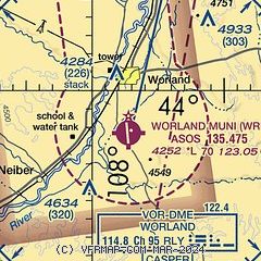
| Sectional chart |
|---|
|
| Airport distance calculator |
|---|
|
|
| Sunrise and sunset |
|---|
|
Times for 11-Jan-2026
| | Local
(UTC-7) | | Zulu
(UTC) |
|---|
| Morning civil twilight | | 07:14 | | 14:14 |
| Sunrise | | 07:46 | | 14:46 |
| Sunset | | 16:54 | | 23:54 |
| Evening civil twilight | | 17:26 | | 00:26 |
|
| Current date and time |
|---|
| Zulu (UTC) | 11-Jan-2026 11:55:17 |
|---|
| Local (UTC-7) | 11-Jan-2026 04:55:17 |
|---|
|
| METAR |
|---|
| KWRL | 111053Z AUTO 00000KT 10SM CLR M06/M12 A3043 RMK AO2 SLP340 T10611117
|
|
| TAF |
|---|
| KWRL | 110526Z 1106/1206 13006KT P6SM SCT120 BKN200 FM111700 VRB05KT P6SM FEW120 SCT200 FM120200 15006KT P6SM FEW100 SCT150
|
|
| NOTAMs |
|---|
NOTAMs are issued by the DoD/FAA and will open in a separate window not controlled by AirNav.
|
|

