FAA INFORMATION EFFECTIVE 11 JUNE 2026
Location
| FAA Identifier: | M79 |
| Lat/Long: | 32-29-07.5110N 091-46-15.8390W
32-29.125183N 091-46.263983W
32.4854197,-91.7710664
(estimated) |
| Elevation: | 82.7 ft. / 25.2 m (surveyed) |
| Variation: | 02E (2000) |
| From city: | 1 mile NW of RAYVILLE, LA |
| Time zone: | UTC -5 (UTC -6 during Standard Time) |
| Zip code: | 71269 |
Airport Operations
| Airport use: | Open to the public |
| Activation date: | 09/1950 |
| Control tower: | no |
| ARTCC: | FORT WORTH CENTER |
| FSS: | DE RIDDER FLIGHT SERVICE STATION |
| NOTAMs facility: | DRI (NOTAM-D service available) |
| Attendance: | UNATNDD
FOR SVCS AFT HRS CALL 318-235-3177. |
| Wind indicator: | lighted |
| Segmented circle: | no |
| Lights: | DUSK-DAWN. MIRL RY 18/36, REIL RYS 18 & 36 PRESET LOW INTST DUSK-DAWN; TO INCR INTST ACTVT - CTAF. |
| Beacon: | white-green (lighted land airport)
Operates sunset to sunrise. |
Airport Communications
| CTAF/UNICOM: | 122.8 |
| MONROE APPROACH: | 126.9 |
| MONROE DEPARTURE: | 126.9 |
| WX ASOS at MLU (13 nm W): | PHONE 318-327-5675 |
| WX AWOS-3PT at BQP (17 nm N): | 118.375 (318-281-1443) |
- APCH/DEP CTL SVC PRVDD BY FORT WORTH ARTCC (ZFW) ON FREQS 126.325/346.25 (MONROE RCAG) WHEN MONROE APCH CTL (MLU) CLSD.
Nearby radio navigation aids
| VOR radial/distance | | VOR name | | Freq | | Var |
|---|
| MLUr095/13.5 | | MONROE VORTAC | | 117.20 | | 03E |
| NDB name | | Hdg/Dist | | Freq | | Var | | ID |
|---|
| BASTROP | | 158/17.1 | | 329 | | 03E | | BQP | -... --.- .--. |
Airport Services
| Parking: | tiedowns |
| Airframe service: | MAJOR |
| Powerplant service: | MAJOR |
| Bottled oxygen: | NONE |
| Bulk oxygen: | NONE |
Runway Information
Runway 18/36
| Dimensions: | 3998 x 75 ft. / 1219 x 23 m |
| Surface: | asphalt, in good condition |
| Weight bearing capacity: | |
| Runway edge lights: | medium intensity |
| RUNWAY 18 | | RUNWAY 36 |
| Latitude: | 32-29.449390N | | 32-28.790492N |
| Longitude: | 091-46.328873W | | 091-46.354168W |
| Elevation: | 82.3 ft. | | 81.0 ft. |
| Traffic pattern: | left | | left |
| Runway heading: | 180 magnetic, 182 true | | 000 magnetic, 002 true |
| Displaced threshold: | no | | 291 ft. |
| Markings: | nonprecision, in good condition | | nonprecision, in good condition |
| Visual slope indicator: | 2-light PAPI on left (3.00 degrees glide path) | | 2-light PAPI on left (3.00 degrees glide path) |
| Runway end identifier lights: | yes | | yes |
| Touchdown point: | yes, no lights | | yes, no lights |
| Obstructions: | 83 ft. trees, 2006 ft. from runway, 21:1 slope to clear | | 27 ft. trees, 465 ft. from runway, 9:1 slope to clear
APCH SLP 12:1 TO DSPLCD THLD. |
Airport Ownership and Management from official FAA records
| Ownership: | Publicly-owned |
| Owner: | CITY OF RAYVILLE
PO BOX 878
RAYVILLE, LA 71269
Phone 318-728-2011 |
| Manager: | CHARLIE ADAMS
12 ELLIS LANE
RAYVILLE, LA 71269
Phone 318-235-0187 |
Additional Remarks
| - | ROAD 367 FT & RR TRACK 467 FT FM APCH END RY 36. |
| - | RY 18/36 40-80 FT TREES WEST SIDE OF RY PENETRATE TRANSITION SLOPE. |
| - | FOR CD CTC MONROE APCH AT 318-327-5641, IF UNAVBL, CTC FORT WORTH ARTCC AT 817-858-7584. |
| - | CTC APRT MGR FOR DSGND RAMP SPACE FOR PUB USE. |
Instrument Procedures
NOTE: All procedures below are presented as PDF files. If you need a reader for these files, you should download the free Adobe Reader.NOT FOR NAVIGATION. Please procure official charts for flight.
FAA instrument procedures published for use from 11 June 2026 at 0901Z to 09 July 2026 at 0900z.
IAPs - Instrument Approach Procedures |
|---|
| RNAV (GPS) RWY 18 | |
download (237KB) |
| RNAV (GPS) RWY 36 | |
download (214KB) |
| NOTE: Special Take-Off Minimums/Departure Procedures apply | |
download (323KB) |
Other nearby airports with instrument procedures:
KMLU - Monroe Regional Airport (13 nm W)
KBQP - Morehouse Memorial Airport (17 nm N)
KTVR - Vicksburg Tallulah Regional Airport (38 nm E)
KRSN - Ruston Regional Airport (41 nm W)
KCRT - Z M Jack Stell Field Airport (42 nm N)
|
|

Road maps at:
MapQuest
Bing
Google
| Aerial photo |
|---|
WARNING: Photo may not be current or correct
 Photo by Mark Burns
Photo taken 21-Oct-2006
Photo by Mark Burns
Photo taken 21-Oct-2006
Do you have a better or more recent aerial photo of John H Hooks Jr Memorial Airport that you would like to share? If so, please send us your photo.
|
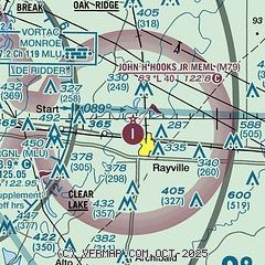
| Sectional chart |
|---|
|
| Airport distance calculator |
|---|
|
|
| Sunrise and sunset |
|---|
|
Times for 27-Jun-2026
| | Local
(UTC-5) | | Zulu
(UTC) |
|---|
| Morning civil twilight | | 05:34 | | 10:34 |
| Sunrise | | 06:03 | | 11:03 |
| Sunset | | 20:17 | | 01:17 |
| Evening civil twilight | | 20:46 | | 01:46 |
|
| Current date and time |
|---|
| Zulu (UTC) | 27-Jun-2026 05:28:58 |
|---|
| Local (UTC-5) | 27-Jun-2026 00:28:58 |
|---|
|
| METAR |
|---|
KMLU
13nm W | 270453Z AUTO 18005KT 10SM CLR 28/24 A3003 RMK AO2 SLP166 T02780239
|
KBQP
17nm N | 270510Z AUTO 00000KT 27/23 A3003 RMK AO2 T02700232 PWINO
|
|
| TAF |
|---|
KMLU
13nm W | 261955Z 2620/2718 21012G18KT P6SM SCT040 SCT150 SCT250 FM270100 19009KT P6SM FEW050 SCT150 SCT250 FM271000 20006KT P6SM SCT025 SCT150 TEMPO 2711/2715 BKN025 FM271700 21010KT P6SM SCT040 BKN150 BKN250
|
|
| NOTAMs |
|---|
NOTAMs are issued by the DoD/FAA and will open in a separate window not controlled by AirNav.
|
|

