FAA INFORMATION EFFECTIVE 18 APRIL 2024
Location
| FAA Identifier: | N72 |
| Lat/Long: | 41-17-15.3370N 074-17-13.5410W
41-17.255617N 074-17.225683W
41.2875936,-74.2870947
(estimated) |
| Elevation: | 540 ft. / 164.6 m (surveyed) |
| Variation: | 13W (1985) |
| From city: | 3 miles NE of WARWICK, NY |
| Time zone: | UTC -4 (UTC -5 during Standard Time) |
| Zip code: | 10990 |
Airport Operations
| Airport use: | Open to the public |
| Activation date: | 01/1940 |
| Control tower: | no |
| ARTCC: | NEW YORK CENTER |
| FSS: | NEW YORK FLIGHT SERVICE STATION |
| NOTAMs facility: | ISP (NOTAM-D service available) |
| Attendance: | IREG |
| Wind indicator: | yes |
| Segmented circle: | no |
| Lights: | ACTVT LIRL RWY 03R/21L - CTAF. |
Airport Communications
| CTAF/UNICOM: | 123.0 |
| WX ASOS at MGJ (13 nm N): | 119.275 (845-457-1486) |
| WX ASOS at FWN (16 nm W): | 118.525 (973-875-0859) |
Nearby radio navigation aids
| VOR radial/distance | | VOR name | | Freq | | Var |
|---|
| HUOr129/15.5 | | HUGUENOT VOR/DME | | 116.10 | | 11W |
| SAXr052/17.4 | | SPARTA VORTAC | | 115.70 | | 11W |
| TEBr350/28.2 | | TETERBORO VOR/DME | | 108.40 | | 11W |
| IGNr235/30.8 | | KINGSTON VOR/DME | | 117.60 | | 12W |
| STWr067/31.6 | | STILLWATER VOR/DME | | 109.60 | | 11W |
| CMKr283/31.8 | | CARMEL VOR/DME | | 116.60 | | 12W |
| LGAr340/35.7 | | LA GUARDIA VOR/DME | | 113.10 | | 12W |
| BWZr051/38.0 | | BROADWAY VOR/DME | | 114.20 | | 11W |
| NDB name | | Hdg/Dist | | Freq | | Var | | ID |
|---|
| NEELY | | 207/12.2 | | 335 | | 14W | | SW | ... .-- |
| STANWYCK | | 229/18.1 | | 261 | | 12W | | SKU | ... -.- ..- |
Airport Services
| Fuel available: | 100LL
100LL:SELF SVC FUEL AVBL. |
| Parking: | tiedowns |
| Airframe service: | NONE |
| Powerplant service: | NONE |
| Bottled oxygen: | NONE |
| Bulk oxygen: | NONE |
Runway Information
Runway 3R/21L
| Dimensions: | 2150 x 28 ft. / 655 x 9 m |
| Surface: | asphalt, in good condition |
| Runway edge lights: | non-standard
RWY 03R/21L NSTD LIRL HAS SPACING 400 FT APART. |
| RUNWAY 3R | | RUNWAY 21L |
| Traffic pattern: | left | | left |
| Markings: | numbers only, in good condition | | numbers only, in good condition |
| Runway end identifier lights: | no | | no |
| Obstructions: | 93 ft. tree, 1249 ft. from runway, 65 ft. right of centerline, 11:1 slope to clear
RWY 03R 35 FT TREES 22 FT FM THR 95 FT RIGHT. | | 61 ft. trees, 694 ft. from runway, 8:1 slope to clear
RWY 21L 38 FT TREES 170 FT FM THR 90 FT LEFT. |
Runway 8/26
| Dimensions: | 2250 x 80 ft. / 686 x 24 m |
| Surface: | turf, in good condition |
| RUNWAY 8 | | RUNWAY 26 |
| Traffic pattern: | left | | left |
| Runway end identifier lights: | no | | no |
| Obstructions: | 60 ft. tree, 77 ft. from runway, 64 ft. left of centerline, 1:1 slope to clear | | 52 ft. tree, 158 ft. from runway, 99 ft. right of centerline, 3:1 slope to clear |
Runway 3L/21R
| Dimensions: | 2100 x 50 ft. / 640 x 15 m |
| Surface: | turf, in good condition |
| RUNWAY 3L | | RUNWAY 21R |
| Traffic pattern: | left | | left |
| Obstructions: | 68 ft. trees, 117 ft. left of centerline | | 56 ft. trees, 38 ft. from runway, 54 ft. right of centerline |
Airport Ownership and Management from official FAA records
| Ownership: | Publicly-owned |
| Owner: | TOWN OF WARWICK
BOX 489
WARWICK, NY 10990
Phone 845-986-9544 |
| Manager: | JEFF WALKER
41 AIRPORT RD
WARWICK, NY 10990
Phone 845-258-0183 |
Airport Operational Statistics
| Aircraft based on the field: | | 45 | | Single engine airplanes: | | 45 |
| |  | |
| Aircraft operations: avg 86/week * | | 83% | local general aviation | | 17% | transient general aviation | | * for 12-month period ending 01 September 2023 | |
Additional Remarks
| - | ARPT CLSD TO TSNT ACFT SS-SR. |
| - | PRACTICE LDGS NA. |
| - | MTS & TWRS IN CLOSE VCNTY OF ARPT. |
| - | RWY 08 HAS 6 FT CHAIN LINK FENCE, 58 FT LEFT, PARLTO RWY. |
| - | FOR CD CTC NEW YORK APCH AT 516-683-2448. |
| - | DEER AND BIRD ACT NEAR MOVEMENT AREAS. |
| - | SEAPLANE USE OF WICKHAM LAKE PROHIBITED. |
Instrument Procedures
There are no published instrument procedures at N72.
Some nearby airports with instrument procedures:
06N - Randall Airport (10 nm NW)
4N1 - Greenwood Lake Airport (10 nm S)
KMGJ - Orange County Airport (13 nm N)
KSWF - New York Stewart International Airport (15 nm NE)
KFWN - Sussex Airport (16 nm W)
|
|

Road maps at:
MapQuest
Bing
Google
| Aerial photo |
|---|
WARNING: Photo may not be current or correct
 Photo taken 17-Aug-2011
looking southwest.
Photo taken 17-Aug-2011
looking southwest.
Do you have a better or more recent aerial photo of Warwick Municipal Airport that you would like to share? If so, please send us your photo.
|
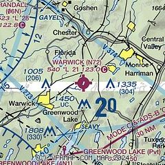
| Sectional chart |
|---|
|
| Airport distance calculator |
|---|
|
|
| Sunrise and sunset |
|---|
|
Times for 24-Apr-2024
| | Local
(UTC-4) | | Zulu
(UTC) |
|---|
| Morning civil twilight | | 05:34 | | 09:34 |
| Sunrise | | 06:04 | | 10:04 |
| Sunset | | 19:47 | | 23:47 |
| Evening civil twilight | | 20:16 | | 00:16 |
|
| Current date and time |
|---|
| Zulu (UTC) | 24-Apr-2024 12:19:04 |
|---|
| Local (UTC-4) | 24-Apr-2024 08:19:04 |
|---|
|
| METAR |
|---|
KMGJ
14nm N | SuperAWOS
241154Z AUTO 21003KT 10SM SCT060 08/01 A2981 RMK AO2 SLP095 T00830011 10083 20072 55004
|
KSWF
16nm NE | 241145Z 00000KT 10SM BKN060 09/01 A2982
|
KFWN
16nm W | 241153Z AUTO 21003KT 10SM BKN065 09/02 A2983 RMK AO2 SLP102 T00940022 10106 20083 55003
|
KCDW
24nm S | 241153Z 10SM BKN090 OVC100 10/02 A2984 RMK AO2 SLP111 60000 T01000017 10111 20100 56002
|
K12N
26nm SW | 241154Z AUTO 22003KT 09/03 A2983 RMK AO1 SLP102 T00890028 10094 20078 55002
|
KTEB
27nm SE | 241151Z 21005KT 10SM -RA OVC070 10/04 A2983 RMK AO2 DZE24RAB24 SLP102 P0000 60000 T01000039 10106 20094 55003
|
|
| TAF |
|---|
KSWF
16nm NE | 241141Z 2412/2518 22004KT P6SM VCSH BKN050 FM241400 30012G20KT P6SM BKN070 FM241700 29015G23KT P6SM VCSH BKN040 FM242100 32017G25KT P6SM SCT050 SCT100 FM250100 34013G21KT P6SM SKC FM250400 36010KT P6SM SKC FM250700 02007KT P6SM SKC AMD NOT SKED
|
|
| NOTAMs |
|---|
NOTAMs are issued by the DoD/FAA and will open in a separate window not controlled by AirNav.
|
|

