FAA INFORMATION EFFECTIVE 25 DECEMBER 2025
Location
| FAA Identifier: | O28 |
| Lat/Long: | 39-27-04.7840N 123-22-20.3910W
39-27.079733N 123-22.339850W
39.4513289,-123.3723308
(estimated) |
| Elevation: | 2065.9 ft. / 629.7 m (surveyed) |
| Variation: | 16E (2000) |
| From city: | 3 miles NW of WILLITS, CA |
| Time zone: | UTC -8 (UTC -7 during Daylight Saving Time) |
| Zip code: | 95490 |
Airport Operations
| Airport use: | Open to the public |
| Activation date: | 08/1964 |
| Control tower: | no |
| ARTCC: | OAKLAND CENTER |
| FSS: | OAKLAND FLIGHT SERVICE STATION |
| NOTAMs facility: | OAK (NOTAM-D service available) |
| Attendance: | UNATNDD |
| Wind indicator: | lighted |
| Segmented circle: | yes |
| Lights: | ACTVT PAPI RWY 34; MIRL RWY 16/34 - CTAF. |
| Beacon: | white-green (lighted land airport)
DUSK-DAWN. BCN OTS INDEFLY. |
Airport Communications
| CTAF/UNICOM: | 122.8 |
| WX AWOS-A at CN01 (20 nm W): | PHONE 707-961-4603 |
- APCH/DEP CTL SVC PRVDD BY OAKLAND ARTCC (ZOA) ON FREQS 132.2/350.3 (UKIAH RCAG).
Nearby radio navigation aids
| VOR radial/distance | | VOR name | | Freq | | Var |
|---|
| ENIr333/24.3 | | MENDOCINO VORTAC | | 112.30 | | 16E |
Airport Services
| Fuel available: | 100LL
100LL:FUEL AVBL 24 HRS WITH CREDIT CARD. |
| Parking: | tiedowns |
| Airframe service: | MINOR |
| Powerplant service: | MINOR |
Runway Information
Runway 16/34
| Dimensions: | 2705 x 75 ft. / 824 x 23 m |
| Surface: | asphalt, in good condition |
| Weight bearing capacity: | |
| Runway edge lights: | medium intensity |
| RUNWAY 16 | | RUNWAY 34 |
| Latitude: | 39-27.301738N | | 39-26.857730N |
| Longitude: | 123-22.363603W | | 123-22.316092W |
| Elevation: | 2065.9 ft. | | 2028.3 ft. |
| Traffic pattern: | left | | right |
| Runway heading: | 159 magnetic, 175 true | | 339 magnetic, 355 true |
| Markings: | nonprecision, in good condition | | nonprecision, in good condition |
| Visual slope indicator: | | | 2-light PAPI on left (3.00 degrees glide path) |
| Runway end identifier lights: | no | | no |
| Touchdown point: | yes, no lights | | yes, no lights |
| Obstructions: | 11 ft. trees, 240 ft. from runway, 80 ft. right of centerline, 3:1 slope to clear | | 38 ft. trees, 1000 ft. from runway, 200 ft. right of centerline, 21:1 slope to clear |
Airport Ownership and Management from official FAA records
| Ownership: | Publicly-owned |
| Owner: | CITY OF WILLITS
111 E COMMERCIAL ST.
WILLITS, CA 95490
Phone 707-459-4605 |
| Manager: | CATHY MOORHEAD
111 EAST COMMERCIAL STREET
WILLITS, CA 95490
Phone 707-459-7121
EMAIL: KOSHEA@WILLITSAIRPORT.COM |
Additional Remarks
| - | DEER AND TURKEYS ON AND INVOF RY. |
| - | ACFT NOT VISIBLE FROM OPPOSITE ENDS OF THE RUNWAY. |
| - | FOR CD CTC OAKLAND ARTCC AT 510-745-3380. |
Instrument Procedures
NOTE: All procedures below are presented as PDF files. If you need a reader for these files, you should download the free Adobe Reader.NOT FOR NAVIGATION. Please procure official charts for flight.
FAA instrument procedures published for use from 25 December 2025 at 0901z to 22 January 2026 at 0900z.
IAPs - Instrument Approach Procedures |
|---|
| RNAV (GPS) RWY 16 | |
download (223KB) |
| RNAV (GPS) RWY 34 | |
download (228KB) |
|
|---|
| FLUEN TWO (OBSTACLE) (RNAV) | |
download (125KB) |
| MENDOCINO ONE (OBSTACLE) (RNAV) | |
download (113KB) |
| NOTE: Special Take-Off Minimums/Departure Procedures apply | |
download (347KB) |
Other nearby airports with instrument procedures:
KLLR - Little River Airport (21 nm SW)
KUKI - Ukiah Municipal Airport (21 nm S)
1O2 - Lampson Field Airport (35 nm SE)
O60 - Cloverdale Municipal Airport (44 nm SE)
KHES - Healdsburg Municipal Airport (53 nm SE)
|
|

Road maps at:
MapQuest
Bing
Google
| Aerial photo |
|---|
WARNING: Photo may not be current or correct
 Photo courtesy of Pilot Getaways magazine
www.pilotgetaways.com/
Do you have a better or more recent aerial photo of Willits Municipal Airport - Ells Field that you would like to share? If so, please send us your photo.
|
| Sectional chart |
|---|
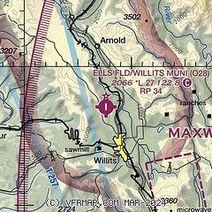
|
| Airport distance calculator |
|---|
|
|
| Sunrise and sunset |
|---|
|
Times for 29-Dec-2025
| | Local
(UTC-8) | | Zulu
(UTC) |
|---|
| Morning civil twilight | | 07:04 | | 15:04 |
| Sunrise | | 07:34 | | 15:34 |
| Sunset | | 16:57 | | 00:57 |
| Evening civil twilight | | 17:27 | | 01:27 |
|
| Current date and time |
|---|
| Zulu (UTC) | 29-Dec-2025 20:41:52 |
|---|
| Local (UTC-8) | 29-Dec-2025 12:41:52 |
|---|
|
| METAR |
|---|
KLLR
21nm SW | SuperAWOS
292015Z AUTO 00000KT 10SM CLR 16/03 A3029 RMK A01
|
KUKI
22nm S | 291956Z AUTO 33003KT 10SM CLR 10/03 A3032 RMK AO2 SLP266 T01000033
|
|
| TAF |
|---|
KUKI
22nm S | 291735Z 2918/3018 VRB03KT P6SM SKC FM301000 00000KT 1/2SM FG BKN001 FM301400 00000KT 1/4SM FG VV001 FM301700 00000KT P6SM SKC
|
|
| NOTAMs |
|---|
NOTAMs are issued by the DoD/FAA and will open in a separate window not controlled by AirNav.
|
|

