FAA INFORMATION EFFECTIVE 25 DECEMBER 2025
Location
| FAA Identifier: | ENN |
| Lat/Long: | 64-32-50.2800N 149-04-26.1300W
64-32.838000N 149-04.435500W
64.5473000,-149.0739250
(estimated) |
| Elevation: | 367.7 ft. / 112.1 m (surveyed) |
| Variation: | 13E (2030) |
| From city: | 1 mile S of NENANA, AK |
| Time zone: | UTC -9 (UTC -8 during Daylight Saving Time) |
| Zip code: | 99760 |
Airport Operations
| Airport use: | Open to the public |
| Activation date: | 04/1949 |
| Control tower: | no |
| ARTCC: | ANCHORAGE CENTER |
| FSS: | FAIRBANKS FLIGHT SERVICE STATION [907-474-0788] |
| NOTAMs facility: | ENN (NOTAM-D service available) |
| Attendance: | UNATTND |
| Wind indicator: | lighted |
| Segmented circle: | yes
DAMAGED. |
| Lights: | ACTVT REIL RWY 04L & 22R; PAPI 04L & 22R; MIRL RWY 04L/22R - CTAF. |
| Beacon: | white-green (lighted land airport)
Operates sunset to sunrise. |
Airport Communications
| CTAF: | 122.1 |
| WX ASOS: | 125.2 (907-832-5689) |
| FAIRBANKS APPROACH: | 125.35 |
| FAIRBANKS DEPARTURE: | 125.35 |
- COMMUNICATIONS PRVDD BY FAIRBANKS FSS ON FREQ 122.50 (NENANA RCO).
Nearby radio navigation aids
| VOR radial/distance | | VOR name | | Freq | | Var |
|---|
| ENNr160/2.6 | | NENANA VORTAC | | 115.80 | | 21E |
| FAIr220/31.2 | | FAIRBANKS VORTAC | | 108.60 | | 21E |
| NDB name | | Hdg/Dist | | Freq | | Var | | ID |
|---|
| ICE POOL | | at field | | 525 | | 13E | | ICW | .. -.-. .-- |
Airport Services
| Fuel available: | 100LL JET-A |
| Parking: | tiedowns |
Runway Information
Runway 4L/22R
| Dimensions: | 4600 x 100 ft. / 1402 x 30 m |
| Surface: | asphalt, in good condition |
| Weight bearing capacity: | |
| Runway edge lights: | medium intensity
OTS INDEF. |
| RUNWAY 4L | | RUNWAY 22R |
| Latitude: | 64-32.736145N | | 64-33.125497N |
| Longitude: | 149-05.223363W | | 149-03.721063W |
| Elevation: | 367.6 ft. | | 365.2 ft. |
| Traffic pattern: | right | | left |
| Runway heading: | 046 magnetic, 059 true | | 226 magnetic, 239 true |
| Markings: | nonprecision, in good condition | | nonprecision, in good condition |
| Visual slope indicator: | 4-light PAPI on left (3.00 degrees glide path) | | 4-light PAPI on left (3.00 degrees glide path) |
| Runway end identifier lights: | yes | | yes |
| Touchdown point: | yes, no lights | | yes, no lights |
| Obstructions: | 30 ft. trees, 201 ft. from runway, 220 ft. left of centerline | | 31 ft. trees, 360 ft. from runway, 142 ft. left and right of centerline, 5:1 slope to clear |
Runway 4R/22L
| Dimensions: | 1980 x 80 ft. / 604 x 24 m
FULL LEN MAY BE UNAVBL DURG SUMMER. SKI USE WHEN FROZEN. |
| Surface: | turf, in good condition |
| Runway edge lights: | medium intensity
OTS INDEF. |
| RUNWAY 4R | | RUNWAY 22L |
| Latitude: | 64-32.745625N | | 64-32.913237N |
| Longitude: | 149-04.965120W | | 149-04.318445W |
| Elevation: | 363.8 ft. | | 363.5 ft. |
| Traffic pattern: | right | | left |
| Runway heading: | 046 magnetic, 059 true | | 226 magnetic, 239 true |
| Markings: | none, in fair condition | | none, in fair condition |
| Touchdown point: | yes, no lights | | yes, no lights |
| Obstructions: | 30 ft. trees, 65 ft. right of centerline | | 23 ft. trees, 70 ft. left of centerline |
Runway 4W/22W
| Dimensions: | 3601 x 100 ft. / 1098 x 30 m |
| Surface: | water |
| RUNWAY 4W | | RUNWAY 22W |
| Latitude: | 64-32.558833N | | 64-32.889333N |
| Longitude: | 149-04.843833W | | 149-03.706167W |
| Elevation: | 352.1 ft. | | 352.1 ft. |
| Traffic pattern: | right | | left |
| Runway heading: | 043 magnetic, 056 true | | 223 magnetic, 236 true |
| Markings: | buoys, in good condition | | buoys, in good condition |
| Touchdown point: | yes, no lights | | yes, no lights |
Airport Ownership and Management from official FAA records
| Ownership: | Publicly-owned |
| Owner: | CITY OF NENANA
BOX 70
NENANA, AK 99760
Phone 907-832-5441 |
| Manager: | DAN SMITH
NENANA, AK 99760
Phone 907-888-9065 |
Additional Remarks
| - | SHALLOW WATER NEAR FLOAT POND RAMP AREA. |
| - | WX CAMERA AVBL ON INTERNET AT HTTPS://WEATHERCAMS.FAA.GOV |
| - | RWY COND UNMNT; RCMD VISUAL INSP BFR USE. |
| - | SELF SVC FUEL H24 WITH CREDIT CARD. |
Instrument Procedures
NOTE: All procedures below are presented as PDF files. If you need a reader for these files, you should download the free Adobe Reader.NOT FOR NAVIGATION. Please procure official charts for flight.
FAA instrument procedures published for use from 25 December 2025 at 0901z to 22 January 2026 at 0900z.
IAPs - Instrument Approach Procedures |
|---|
| RNAV (GPS) RWY 04L **CHANGED** | |
download (241KB) |
| NDB RWY 04L **CHANGED** | |
download (240KB) |
| NOTE: Special Alternate Minimums apply **CHANGED** | |
download (172KB) |
| NOTE: Special Take-Off Minimums/Departure Procedures apply **CHANGED** | |
download (395KB) |
Other nearby airports with instrument procedures:
PAFA - Fairbanks International Airport (35 nm NE)
PAHV - Healy River Airport (41 nm S)
PAFB - Ladd Army Airfield (41 nm NE)
PAML - Manley Hot Springs Airport (48 nm NW)
PAEI - Eielson Air Force Base (51 nm E)
|
|

Road maps at:
MapQuest
Bing
Google
| Aerial photo |
|---|
WARNING: Photo may not be current or correct

Do you have a better or more recent aerial photo of Nenana Municipal Airport that you would like to share? If so, please send us your photo.
|
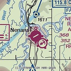
| Sectional chart |
|---|
|
| Airport distance calculator |
|---|
|
|
| Sunrise and sunset |
|---|
|
Times for 01-Jan-2026
| | Local
(UTC-9) | | Zulu
(UTC) |
|---|
| Morning civil twilight | | 09:36 | | 18:36 |
| Sunrise | | 10:56 | | 19:56 |
| Sunset | | 15:05 | | 00:05 |
| Evening civil twilight | | 16:24 | | 01:24 |
|
| Current date and time |
|---|
| Zulu (UTC) | 01-Jan-2026 10:45:34 |
|---|
| Local (UTC-9) | 01-Jan-2026 01:45:34 |
|---|
|
| METAR |
|---|
| PANN | 011030Z AUTO 30003KT 1 1/2SM BR FEW002 M42/ A3053 RMK AO2 T1422 TSNO $
|
|
| TAF |
|---|
PAFA
35nm NE | 010522Z 0106/0212 00000KT 1/2SM FZFG SCT002 FM020000 00000KT 5SM BR SKC
|
PAFB
41nm NE | 312138Z 3121/0121 VRB06KT 1600 HZ SCT100 QNH3050INS TEMPO 0100/0103 0800 FZFG BECMG 0112/0113 VRB06KT 4800 BR SKC QNH3033INS TXM39/0122Z TNM42/0110Z LAST NO AMDS AFT 3121 NEXT 0115
|
|
| NOTAMs |
|---|
NOTAMs are issued by the DoD/FAA and will open in a separate window not controlled by AirNav.
|
|

