FAA INFORMATION EFFECTIVE 09 JULY 2026
Location
| FAA Identifier: | VEE |
| Lat/Long: | 67-00-31.2300N 146-21-58.8900W
67-00.520500N 146-21.981500W
67.0086750,-146.3663583
(estimated) |
| Elevation: | 574.1 ft. / 175.0 m (surveyed) |
| Variation: | 18E (2020) |
| From city: | 1 mile E of VENETIE, AK |
| Time zone: | UTC -8 (UTC -9 during Standard Time) |
| Zip code: | 99781 |
Airport Operations
| Airport use: | Open to the public |
| Activation date: | 08/1959 |
| Control tower: | no |
| ARTCC: | ANCHORAGE CENTER |
| FSS: | FAIRBANKS FLIGHT SERVICE STATION [907-474-0788] |
| NOTAMs facility: | FAI (NOTAM-D service available) |
| Attendance: | UNATNDD |
| Wind indicator: | lighted |
| Segmented circle: | yes |
| Lights: | ACTVT MIRL RY 04/22 - CTAF. |
| Beacon: | white-green (lighted land airport)
ACTVT ROTG BCN - CTAF. |
Airport Communications
- APCH/DEP SVC PRVDD BY ANCHORAGE ARTCC ON FREQS 135.0/225.4 (FORT YUKON RCAG).
Nearby radio navigation aids
| VOR radial/distance | | VOR name | | Freq | | Var |
|---|
| FYUr295/36.6 | | FORT YUKON VORTAC | | 114.40 | | 20E |
Airport Services
| Airframe service: | NONE |
| Powerplant service: | NONE |
| Bottled oxygen: | NONE |
| Bulk oxygen: | NONE |
Runway Information
Runway 4/22
| Dimensions: | 4000 x 75 ft. / 1219 x 23 m |
| Surface: | gravel, in good condition
RY 04/22 SFC SLIPPERY WHEN WET, SFC UNEVEN & SPARSELY GRVLD. |
| Runway edge lights: | medium intensity |
| RUNWAY 4 | | RUNWAY 22 |
| Latitude: | 67-00.367500N | | 67-00.673333N |
| Longitude: | 146-22.723500W | | 146-21.239167W |
| Elevation: | 571.3 ft. | | 573.3 ft. |
| Traffic pattern: | left | | left |
| Runway heading: | 044 magnetic, 062 true | | 224 magnetic, 242 true |
| Markings: | none, in good condition | | none, in good condition |
| Runway end identifier lights: | no | | no |
| Touchdown point: | yes, no lights | | yes, no lights |
| Obstructions: | 15 ft. road, 300 ft. from runway, 20:1 slope to clear | | 45 ft. trees, 1006 ft. from runway, 214 ft. left of centerline, 22:1 slope to clear |
Airport Ownership and Management from official FAA records
| Ownership: | Privately-owned |
| Owner: | VENETIE TRIBAL GOVERNMENT
BOX 81080
VENETIE, AK 99781
Phone 907-849-8165 |
| Manager: | EDDIE FRANK
PO BOX 81080
VENETIE, AK 99781-0080
Phone 907-849-8165 |
Additional Remarks
| - | PPR BEFORE LNDG PHONE 907-849-8165. |
| - | MAINT IN WINTER VARIABLE. |
| - | CONSTRUCTION EQUIPMENT & PERSONS OPERATING ON & INVOF OF RY. |
| - | RY 04 ROAD TRANSITS RY APRX 300 FT FM THLD. |
| - | TAXIWAY LGTS OTS INDELFY. |
| - | ROTG BCN OTS INDEFLY. |
Instrument Procedures
NOTE: All procedures below are presented as PDF files. If you need a reader for these files, you should download the free Adobe Reader.NOT FOR NAVIGATION. Please procure official charts for flight.
FAA instrument procedures published for use from 09 July 2026 at 0901Z to 06 August 2026 at 0900Z.
IAPs - Instrument Approach Procedures |
|---|
| RNAV (GPS) RWY 04 | |
download (167KB) |
| RNAV (GPS) RWY 22 | |
download (148KB) |
|
|---|
| VENETIE THREE (OBSTACLE) (RNAV) | |
download (129KB) |
| NOTE: Special Take-Off Minimums/Departure Procedures apply | |
download (398KB) |
Other nearby airports with instrument procedures:
PFYU - Fort Yukon Airport (37 nm SE)
PAWB - Beaver Airport (46 nm SW)
PACI - Chalkyitsik Airport (66 nm E)
PARC - Arctic Village Airport (69 nm N)
PACX - Coldfoot Airport (91 nm W)
|
|

Road maps at:
MapQuest
Bing
Google
| Aerial photo |
|---|
WARNING: Photo may not be current or correct
 Photo by Blaine E. Fisher
Photo taken 26-May-2006
Photo by Blaine E. Fisher
Photo taken 26-May-2006
Do you have a better or more recent aerial photo of Venetie Airport that you would like to share? If so, please send us your photo.
|
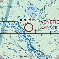
| Sectional chart |
|---|
|
| Airport distance calculator |
|---|
|
|
| Sunrise and sunset |
|---|
|
Times for 02-Aug-2026
| | Local
(UTC-8) | | Zulu
(UTC) |
|---|
| Morning civil twilight | | + | | + |
| Sunrise | | 04:24 | | 12:24 |
| Sunset | | 23:19 | | 07:19 |
| Evening civil twilight | | + | | + |
|
| Current date and time |
|---|
| Zulu (UTC) | 03-Aug-2026 06:02:48 |
|---|
| Local (UTC-8) | 02-Aug-2026 22:02:48 |
|---|
|
| METAR |
|---|
PFYU
37nm SE | 030556Z AUTO 25004KT 10SM SCT090 17/13 A2988 RMK AO2 SLP127 T01720133 10211 20172 56005 TSNO $
|
|
| NOTAMs |
|---|
NOTAMs are issued by the DoD/FAA and will open in a separate window not controlled by AirNav.
|
|

