FAA INFORMATION EFFECTIVE 11 JUNE 2026
Location
| FAA Identifier: | WSN |
| Lat/Long: | 58-42-07.5000N 157-00-09.3000W
58-42.125000N 157-00.155000W
58.7020833,-157.0025833
(estimated) |
| Elevation: | 162.3 ft. / 49 m (estimated) |
| Variation: | 13E (2020) |
| From city: | 1 mile SSW of SOUTH NAKNEK, AK |
| Time zone: | UTC -8 (UTC -9 during Standard Time) |
| Zip code: | 99670 |
Airport Operations
| Airport use: | Open to the public |
| Control tower: | no |
| ARTCC: | ANCHORAGE CENTER |
| FSS: | KENAI FLIGHT SERVICE STATION [907-283-7211] |
| NOTAMs facility: | WSN (NOTAM-D service available) |
| Attendance: | UNATNDD |
| Wind indicator: | lighted |
| Segmented circle: | yes |
| Lights: | ACTVT VASI RWY 13; HIRL RWY 05/23 & 13/31 - CTAF. |
| Beacon: | white-green (lighted land airport)
Operates sunset to sunrise. |
Airport Communications
| CTAF: | 122.9 |
| WX AWOS-3P: | 121.575 (907-868-7348) |
| WX ASOS at AKN (11 nm E): | 128.8 (907-246-7506) |
- APCH CTL PRVDD BY ANCHORAGE ARTCC (ZAN) ON 124.8/354.0 (KING SALMON RCAG).
Nearby radio navigation aids
| VOR radial/distance | | VOR name | | Freq | | Var |
|---|
| AKNr244/7.9 | | KING SALMON VORTAC | | 112.80 | | 16E |
Airport Services
Runway Information
Runway 13/31
| Dimensions: | 3314 x 60 ft. / 1010 x 18 m |
| Surface: | gravel/dirt, in fair condition |
| Runway edge lights: | high intensity |
| Runway edge markings: | SHORT CONES & LIGHTS. |
| RUNWAY 13 | | RUNWAY 31 |
| Latitude: | 58-42.245623N | | 58-41.835172N |
| Longitude: | 157-00.465892W | | 156-59.779600W |
| Elevation: | 156.5 ft. | | 155.6 ft. |
| Traffic pattern: | left | | left |
| Runway heading: | 126 magnetic, 139 true | | 306 magnetic, 319 true |
| Displaced threshold: | no | | 559 ft. |
| Markings: | basic, in fair condition | | NSTD, in fair condition |
| Visual slope indicator: | 2-box VASI on left (3.00 degrees glide path) | | |
| Touchdown point: | yes, no lights | | yes, no lights |
| Obstructions: | 9 ft. brush, 4 ft. from runway, 95 ft. left of centerline | | 6 ft. brush, 72 ft. right of centerline |
Runway 5/23
| Dimensions: | 2264 x 60 ft. / 690 x 18 m |
| Surface: | gravel/dirt, in fair condition |
| Runway edge lights: | high intensity |
| RUNWAY 5 | | RUNWAY 23 |
| Latitude: | 58-42.158252N | | 58-42.338680N |
| Longitude: | 157-00.515297W | | 156-59.891102W |
| Elevation: | 162.3 ft. | | 128.0 ft. |
| Traffic pattern: | left | | left |
| Runway heading: | 048 magnetic, 061 true | | 228 magnetic, 241 true |
| Touchdown point: | yes, no lights | | yes, no lights |
| Obstructions: | 20 ft. brush, 115 ft. left of centerline | | 7 ft. brush, 71 ft. left of centerline |
Airport Ownership and Management from official FAA records
| Ownership: | Publicly-owned |
| Owner: | ALASKA DOT&PF SOUTHCOAST REGION
PO BOX 112500
JUNEAU, AK 99811-2500
Phone 907-465-4512 |
| Manager: | FLOYD WILSON
PO BOX 65
KING SALMON, AK 99613
Phone 907-246-3325 |
Additional Remarks
| - | RWY COND UNMNT; RCMND VISUAL INSP PRIOR TO USE. |
| - | TWY SLPS DOWNHILL TO NW; NO LINE OF SIGHT BTN END OF TWY & RWY 13/31. |
| - | WX CAMERA AVBL ON INTERNET AT HTTPS://WEATHERCAMS.FAA.GOV |
| - | VEHICLES, MOOSE & BEARS ON & INVOF RWYS. |
| - | HVY TFC BTN S NAKNEK & NAKNEK ARPTS LESS THAN 2 MI APART. |
Instrument Procedures
NOTE: All procedures below are presented as PDF files. If you need a reader for these files, you should download the free Adobe Reader.NOT FOR NAVIGATION. Please procure official charts for flight.
FAA instrument procedures published for use from 11 June 2026 at 0901Z to 09 July 2026 at 0900z.
IAPs - Instrument Approach Procedures |
|---|
| RNAV (GPS) RWY 13 | |
download (241KB) |
| RNAV (GPS) RWY 31 | |
download (244KB) |
| NOTE: Special Alternate Minimums apply | |
download (46KB) |
| NOTE: Special Take-Off Minimums/Departure Procedures apply | |
download (204KB) |
Other nearby airports with instrument procedures:
PAKN - King Salmon Airport (11 nm E)
PAII - Egegik Airport (33 nm S)
PANW - New Stuyahok Airport (46 nm N)
PFCL - Clarks Point Airport (48 nm W)
PAIG - Igiugig Airport (50 nm NE)
|
|

Road maps at:
MapQuest
Bing
Google
| Aerial photo |
|---|
WARNING: Photo may not be current or correct
 Photo by William Pierce
Photo taken 13-Jun-2007
Photo by William Pierce
Photo taken 13-Jun-2007
Do you have a better or more recent aerial photo of South Naknek Nr 2 Airport that you would like to share? If so, please send us your photo.
|
| Sectional chart |
|---|
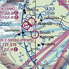
|
| Airport distance calculator |
|---|
|
|
| Sunrise and sunset |
|---|
|
Times for 20-Jun-2026
| | Local
(UTC-8) | | Zulu
(UTC) |
|---|
| Morning civil twilight | | 03:55 | | 11:55 |
| Sunrise | | 05:18 | | 13:18 |
| Sunset | | 23:41 | | 07:41 |
| Evening civil twilight | | 01:04 | | 09:04 |
|
| Current date and time |
|---|
| Zulu (UTC) | 21-Jun-2026 03:04:52 |
|---|
| Local (UTC-8) | 20-Jun-2026 19:04:52 |
|---|
|
| METAR |
|---|
| PFWS | 210256Z AUTO 28007KT 10SM FEW050 OVC080 14/10 A3011 RMK AO2 SLP197 T01440100 56009
|
PAKN
11nm E | 210254Z 23007KT 10SM OVC038 15/10 A3007 RMK AO2 SLP182 T01500100 56006 $
|
|
| TAF |
|---|
PAKN
11nm E | 201730Z 2018/2118 VRB03KT P6SM OVC080 FM210600 21007KT P6SM -RA OVC020 FM211100 17004KT 4SM -RA BR OVC007
|
|
| NOTAMs |
|---|
NOTAMs are issued by the DoD/FAA and will open in a separate window not controlled by AirNav.
|
|

