FAA INFORMATION EFFECTIVE 09 JULY 2026
Location
| FAA Identifier: | S44 |
| Lat/Long: | 37-16-06.7268N 100-35-02.1378W
37-16.112113N 100-35.035630W
37.2685352,-100.5839272
(estimated) |
| Elevation: | 2762 ft. / 842 m (estimated) |
| Variation: | 09E (1985) |
| Time zone: | UTC -5 (UTC -6 during Standard Time) |
| Zip code: | 67869 |
Airport Operations
| Airport use: | Open to the public |
| Activation date: | 07/1941 |
| Control tower: | no |
| ARTCC: | KANSAS CITY CENTER |
| FSS: | WICHITA FLIGHT SERVICE STATION |
| Attendance: | UNATNDD |
| Wind indicator: | yes |
| Segmented circle: | no |
Airport Communications
| WX AWOS-3PT at MEJ (11 nm E): | 119.425 (620-518-2544) |
| WX AWOS-3P at 19S (18 nm NW): | 118.4 (620-290-3873) |
Nearby radio navigation aids
| VOR radial/distance | | VOR name | | Freq | | Var |
|---|
| GCKr159/39.6 | | GARDEN CITY VORTAC | | 113.30 | | 11E |
Airport Services
| Parking: | hangars |
| Airframe service: | NONE |
| Powerplant service: | NONE |
| Bottled oxygen: | NONE |
| Bulk oxygen: | NONE |
Runway Information
Runway 17/35
| Dimensions: | 3350 x 150 ft. / 1021 x 46 m |
| Surface: | turf, in fair condition |
| RUNWAY 17 | | RUNWAY 35 |
| Latitude: | 37-16.282800N | | 37-15.730827N |
| Longitude: | 100-35.027880W | | 100-35.018763W |
| Elevation: | 2760.0 ft. | | 2760.0 ft. |
| Traffic pattern: | left | | left |
| Displaced threshold: | 100 ft. | | 199 ft. |
| Runway end identifier lights: | no | | no |
| Obstructions: | road, 300 ft. from runway, 2:1 slope to clear | | rr, 350 ft. from runway, 2:1 slope to clear |
Runway 8/26
| Dimensions: | 2260 x 150 ft. / 689 x 46 m |
| Surface: | turf, in fair condition |
| RUNWAY 8 | | RUNWAY 26 |
| Latitude: | 37-16.272180N | | 37-16.270800N |
| Longitude: | 100-35.319180W | | 100-34.853280W |
| Elevation: | 2760.0 ft. | | 2760.0 ft. |
| Traffic pattern: | left | | left |
| Displaced threshold: | 150 ft. | | 150 ft. |
| Runway end identifier lights: | no | | no |
| Obstructions: | bldg, 110 ft. from runway, 11:1 slope to clear | | road, 15 ft. from runway, 1:1 slope to clear |
Runway 2/20
| Dimensions: | 1120 x 100 ft. / 341 x 30 m |
| Surface: | turf, in fair condition |
| RUNWAY 2 | | RUNWAY 20 |
| Latitude: | 37-16.026660N | | 37-16.184280N |
| Longitude: | 100-35.030280W | | 100-34.910400W |
| Elevation: | 2760.0 ft. | | 2762.0 ft. |
| Traffic pattern: | left | | left |
| Runway end identifier lights: | no | | no |
| Obstructions: | bldg, 300 ft. from runway, 2:1 slope to clear | | road, 25 ft. from runway, 2:1 slope to clear |
Airport Ownership and Management from official FAA records
| Ownership: | Publicly-owned |
| Owner: | CITY OF PLAINS
404 GRAND AVE., P O BOX 366
PLAINS, KS 67869
Phone 620-563-7611 |
| Manager: | JUNE BENDER
CITY OF PLAINS 404 GRAND AVE, P O BOX 366
PLAINS, KS 67869
Phone 620-563-7611 |
Additional Remarks
| - | FOR CD CTC KANSAS CITY ARTCC AT 913-254-8508. |
Instrument Procedures
There are no published instrument procedures at S44.
Some nearby airports with instrument procedures:
KMEJ - Meade Municipal Airport (11 nm E)
KLBL - Liberal Mid-America Regional Airport (22 nm SW)
KHQG - Hugoton Municipal Airport (38 nm W)
KGCK - Garden City Regional Airport (40 nm N)
KDDC - Dodge City Regional Airport (42 nm NE)
|
|

Road maps at:
MapQuest
Bing
Google
| Aerial photo |
|---|

|
| Sectional chart |
|---|
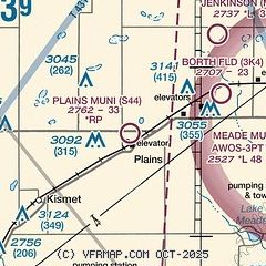
|
| Airport distance calculator |
|---|
|
|
| Sunrise and sunset |
|---|
|
Times for 31-Jul-2026
| | Local
(UTC-5) | | Zulu
(UTC) |
|---|
| Morning civil twilight | | 06:18 | | 11:18 |
| Sunrise | | 06:47 | | 11:47 |
| Sunset | | 20:50 | | 01:50 |
| Evening civil twilight | | 21:19 | | 02:19 |
|
| Current date and time |
|---|
| Zulu (UTC) | 01-Aug-2026 03:21:28 |
|---|
| Local (UTC-5) | 31-Jul-2026 22:21:28 |
|---|
|
| METAR |
|---|
KLBL
23nm SW | 010256Z AUTO 35004KT 7SM CLR 26/14 A3013 RMK AO2 SLP168 T02560139 53018
|
|
| TAF |
|---|
KLBL
23nm SW | 311720Z 3118/0118 35015G25KT P6SM FEW250 FM010000 01010KT P6SM SKC
|
|
| NOTAMs |
|---|
NOTAMs are issued by the DoD/FAA and will open in a separate window not controlled by AirNav.
|
|

