FAA INFORMATION EFFECTIVE 11 JUNE 2026
Location
| FAA Identifier: | SBU |
| Lat/Long: | 43-35-43.3000N 094-05-34.3000W
43-35.721667N 094-05.571667W
43.5953611,-94.0928611
(estimated) |
| Elevation: | 1107.4 ft. / 337.5 m (surveyed) |
| Variation: | 01E (2020) |
| From city: | 3 miles S of BLUE EARTH, MN |
| Time zone: | UTC -5 (UTC -6 during Standard Time) |
| Zip code: | 56013 |
Airport Operations
| Airport use: | Open to the public |
| Activation date: | 03/1942 |
| Control tower: | no |
| ARTCC: | MINNEAPOLIS CENTER |
| FSS: | PRINCETON FLIGHT SERVICE STATION |
| NOTAMs facility: | PNM (NOTAM-D service available) |
| Attendance: | MON-FRI 0800-1700
FOR SVC AFT HRS CALL 507-525-3064 |
| Wind indicator: | lighted |
| Segmented circle: | no |
| Lights: | RWY 16-34 MIRL PRESET TO LOW SS-SR, TO INCR INTS AND ACTVT PAPI RY 16 & RY 34, AND REIL RY 16 & RY 34 - CTAF. |
| Beacon: | white-green (lighted land airport)
Operates sunset to sunrise. |
Airport Communications
| CTAF/UNICOM: | 122.8 |
| WX AWOS-3PT at FRM (14 nm W): | 120.025 (507-618-7358) |
- APCH/DEP SVC PRVDD BY MINNEAPOLIS ARTCC ON 127.75/257.7 (FAIRMONT RCAG).
Nearby radio navigation aids
| VOR radial/distance | | VOR name | | Freq | | Var |
|---|
| AELr260/31.8 | | ALBERT LEA VOR/DME | | 109.80 | | 01E |
| NDB name | | Hdg/Dist | | Freq | | Var | | ID |
|---|
| MONTZ | | 078/9.9 | | 420 | | 04E | | FQ | ..-. --.- |
Airport Services
| Fuel available: | 100LL JET-A
100LL:SELF SERVICE FUEL AVAILABLE WITH CREDIT CARD |
| Parking: | tiedowns |
| Airframe service: | MINOR |
| Powerplant service: | MINOR |
| Bottled oxygen: | NONE |
| Bulk oxygen: | NONE |
Runway Information
Runway 16/34
| Dimensions: | 3400 x 75 ft. / 1036 x 23 m |
| Surface: | concrete, in good condition |
| Weight bearing capacity: | |
| Runway edge lights: | medium intensity |
| RUNWAY 16 | | RUNWAY 34 |
| Latitude: | 43-35.899803N | | 43-35.370357N |
| Longitude: | 094-05.675412W | | 094-05.425895W |
| Elevation: | 1092.4 ft. | | 1107.3 ft. |
| Traffic pattern: | left | | left |
| Runway heading: | 160 magnetic, 161 true | | 340 magnetic, 341 true |
| Markings: | nonprecision, in good condition | | nonprecision, in good condition |
| Visual slope indicator: | 4-light PAPI on left (3.00 degrees glide path) | | 4-light PAPI on left (3.00 degrees glide path) |
| Runway end identifier lights: | yes | | yes |
| Touchdown point: | yes, no lights | | yes, no lights |
Runway 3/21
| Dimensions: | 2245 x 200 ft. / 684 x 61 m |
| Surface: | turf, in good condition |
| Runway edge markings: | MKD WITH YELLOW CONES. |
| RUNWAY 3 | | RUNWAY 21 |
| Latitude: | 43-35.703382N | | 43-36.004817N |
| Longitude: | 094-05.750273W | | 094-05.456302W |
| Elevation: | 1092.8 ft. | | 1090.9 ft. |
| Traffic pattern: | left | | left |
| Runway heading: | 034 magnetic, 035 true | | 214 magnetic, 215 true |
| Runway end identifier lights: | no | | no |
| Touchdown point: | yes, no lights | | yes, no lights |
Airport Ownership and Management from official FAA records
| Ownership: | Publicly-owned |
| Owner: | CITY OF BLUE EARTH
125 W 6TH ST, PO BOX 38
BLUE EARTH, MN 56013
Phone 507-526-7336 |
| Manager: | LUKE STEIER
7575 HWY 169
BLUE EARTH, MN 56013
Phone 507-526-7264
EMAIL ADDRESS: STEIERL@HOTMAIL.COM (ALL LOWER CASE) |
Additional Remarks
| A58-16 | RWY 16 HAS 4 FT BRUSH 35 FT FM THE RWY END AND 154 FT LEFT. |
| - | RY 03/21 CLSD WINTER MONTHS |
| - | DEER & WATERFOWL ON & INVOF ARPT. |
| - | GCO AVBL ON FREQ 121.725 THRU MINNEAPOLIS ARTCC & FLT SVCS. |
| - | FOR CD IF UNA VIA GCO CTC MINNEAPOLIS ARTCC AT 651-463-5588. |
Instrument Procedures
NOTE: All procedures below are presented as PDF files. If you need a reader for these files, you should download the free Adobe Reader.NOT FOR NAVIGATION. Please procure official charts for flight.
FAA instrument procedures published for use from 11 June 2026 at 0901Z to 09 July 2026 at 0900z.
IAPs - Instrument Approach Procedures |
|---|
| RNAV (GPS) RWY 34 **CHANGED** | |
download (229KB) |
| NOTE: Special Take-Off Minimums/Departure Procedures apply | |
download (232KB) |
Other nearby airports with instrument procedures:
KFRM - Fairmont Municipal Airport (14 nm W)
KFXY - Forest City Municipal Airport/Trimble Field (30 nm SE)
KEST - Estherville Municipal Airport (31 nm W)
KJYG - St James Municipal Airport (31 nm NW)
KAEL - Albert Lea Municipal Airport (32 nm E)
|
|

Road maps at:
MapQuest
Bing
Google
| Aerial photo |
|---|
WARNING: Photo may not be current or correct
 Taken in the Fall of 2012
looking southwest.
Taken in the Fall of 2012
looking southwest.
Do you have a better or more recent aerial photo of Blue Earth Municipal Airport that you would like to share? If so, please send us your photo.
|
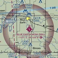
| Sectional chart |
|---|
|
| Airport distance calculator |
|---|
|
|
| Sunrise and sunset |
|---|
|
Times for 04-Jul-2026
| | Local
(UTC-5) | | Zulu
(UTC) |
|---|
| Morning civil twilight | | 05:06 | | 10:06 |
| Sunrise | | 05:42 | | 10:42 |
| Sunset | | 21:00 | | 02:00 |
| Evening civil twilight | | 21:35 | | 02:35 |
|
| Current date and time |
|---|
| Zulu (UTC) | 04-Jul-2026 20:16:20 |
|---|
| Local (UTC-5) | 04-Jul-2026 15:16:20 |
|---|
|
| METAR |
|---|
KFRM
14nm W | 041956Z AUTO 18007KT 10SM CLR 27/22 A3003 RMK AO2 LTG DSNT W AND NW SLP164 T02670222
|
|
| TAF |
|---|
KMKT
38nm N | 041725Z 0418/0518 VRB05KT P6SM SCT040 PROB30 0500/0503 4SM -TSRA BR BKN025CB FM050400 VRB03KT P6SM SCT250 PROB30 0505/0508 4SM -TSRA BR BKN025CB FM050800 05003KT 6SM BR FEW010 FM051300 05005KT P6SM SKC
|
KMCW
43nm SE | 041739Z 0418/0518 VRB05KT P6SM SCT035 SCT080 PROB30 0418/0422 4SM -TSRA BKN027CB
|
|
| NOTAMs |
|---|
NOTAMs are issued by the DoD/FAA and will open in a separate window not controlled by AirNav.
|
|

