FAA INFORMATION EFFECTIVE 09 JULY 2026
Location
| FAA Identifier: | SUN |
| Lat/Long: | 43-30-13.6130N 114-17-44.0100W
43-30.226883N 114-17.733500W
43.5037814,-114.2955583
(estimated) |
| Elevation: | 5319.5 ft. / 1621.4 m (surveyed) |
| Variation: | 13E (2020) |
| From city: | 1 mile SE of HAILEY, ID |
| Time zone: | UTC -6 (UTC -7 during Standard Time) |
| Zip code: | 83313 |
Airport Operations
| Airport use: | Open to the public |
| Activation date: | 04/1940 |
| Control tower: | yes |
| ARTCC: | SALT LAKE CITY CENTER |
| FSS: | BOISE FLIGHT SERVICE STATION |
| NOTAMs facility: | SUN (NOTAM-D service available) |
| Attendance: | 0700-2300 |
| Wind indicator: | lighted |
| Segmented circle: | no |
| Lights: | WHEN ATCT CLSD ACTVT HIRL RWY 13/31 - CTAF. PAPI RWY 31 OPR CONSLY. |
| Beacon: | white-green (lighted land airport)
Operates sunset to sunrise. |
| Landing fee: | yes, LNDG FEE GTR THAN 6000 LB. |
| Fire and rescue: | ARFF index B |
| Airline operations: | AVBL 0700-2300.
PPR FOR SKED ACR OPS 2300-0600 - AMGR. |
Airport Communications
| CTAF: | 125.6 |
| UNICOM: | 122.95 |
| ATIS: | 128.225 |
| WX AWOS-3: | 128.225 (208-788-9213) |
| HAILEY GROUND: | 121.7 [0700-2300] |
| HAILEY TOWER: | 125.6 [0700-2300] |
- APCH/DEP CTL SVC PRVDD BY SALT LAKE ARTCC (ZLC) ON FREQS 118.05/363.0 (BURLEY RCAG).
- FREQ 121.5 NOT AVBL AT TWR.
Nearby radio navigation aids
| NDB name | | Hdg/Dist | | Freq | | Var | | ID |
|---|
| HAILEY | | 335/10.7 | | 220 | | 13E | | HLE | .... .-.. . |
Airport Services
| Fuel available: | 100LL JET-A1+ |
| Parking: | hangars and tiedowns |
| Airframe service: | MAJOR |
| Powerplant service: | MAJOR |
| Bottled oxygen: | HIGH |
| Bulk oxygen: | HIGH |
Runway Information
Runway 13/31
| Dimensions: | 7550 x 100 ft. / 2301 x 30 m |
| Surface: | asphalt/grooved, in good condition |
| Weight bearing capacity: | | Single wheel: | 68.0 | | Double wheel: | 97.0 | | Double tandem: | 162.0 |
|
| Runway edge lights: | high intensity |
| Operational restrictions: | WHEN ATCT CLSD LND RWY 31; TKOF RWY 13; OPDT IN PAT. ATCT 275 FT E OF CNTRLN. |
| RUNWAY 13 | | RUNWAY 31 |
| Latitude: | 43-30.734380N | | 43-29.719348N |
| Longitude: | 114-18.225713W | | 114-17.241413W |
| Elevation: | 5319.5 ft. | | 5261.8 ft. |
| Traffic pattern: | left | | left |
| Runway heading: | 132 magnetic, 145 true | | 312 magnetic, 325 true |
| Displaced threshold: | 1701 ft. | | no |
| Declared distances: | TORA:7550 TODA:7550 ASDA:7550 LDA:5850 | | TORA:5850 TODA:7550 ASDA:6631 LDA:6631 |
| Markings: | nonprecision, in good condition | | precision, in fair condition |
| Visual slope indicator: | | | 4-light PAPI on left (3.50 degrees glide path) |
| Touchdown point: | yes, no lights | | yes, no lights |
| Obstructions: | 17 ft. road, 200 ft. from runway, 190 ft. left of centerline
17 FT RD 450 FT FM THR 250 FT LEFT; 15 FT PIPES 500 FT FM THR 180 FT RIGHT; 7 FT FENCE 550 FT FM THR 180 FT LEFT; 17 FT RD 550 FT FM THR 190 FT LEFT. | | none |
Airport Ownership and Management from official FAA records
| Ownership: | Publicly-owned |
| Owner: | CITY OF HAILEY
BLANE CO - BOX 400
HAILEY, ID 83333
Phone 208-788-4221
208-788-5500. |
| Manager: | TIM BURKE
1616 AIRPORT CIR
HAILEY, ID 83333-5534
Phone 208-720-5186 |
Additional Remarks
| A39-13/31 | PCR VALUE: 260/F/C/X/T |
| - | APCH RWY 31 ALG E SIDE OF VALLEY; DEP RWY 13 ALG W SIDE OF VALLEY; WITH LNDG LGT ON; OPDT. |
| - | LOCKED BRAKE TURNS NA. |
| - | SFC COND UNMNT; ARFF UNAVBL 2300-0700. |
| - | ACR LTD PRKG AVBL. |
| - | RWY LTD TO 95000 LB OR LESS MAX TKOF WT. DUAL WHEEL WITH MAX TKOF WT GTR THAN 95000 LB 48 HR PPR - AMGR. |
| - | APU OPS LTD TO 30 MI. |
| - | TWY B5 & B6 RSTD TO WINGSPAN 79 FT OR LESS; DESIGN GROUP II ONLY. |
| - | GA TSNT LESS THAN 40 FT WINGSPAN PRKG ON SECT 2 APN BLUE TIE DOWN SPOTS. TSNT PRKG - 208-788-9511. |
| - | COLD TEMP ARPT. ALT COR RQRD AT OR BLO -13C. |
| - | TSNT HEL OPS - 208-720-5186. ARPT OPS - 208-788-9511 FOR PRKG. DEDICATED HEL PRKG PADS NA. |
| - | FOR CD IF UNA TO CTC ON FSS FREQ, CTC SALT LAKE ARTCC AT 801-320-2568. |
| - | WHEN ATCT CLSD ARR ANNC ON 125.6 AT 20, 15, 10, 5 MI OUT & SHORT FNA. PAEW ON RWY. |
| - | FUEL SVC AFT DUSK PPR - 208-788-9511. |
| - | PPR FOR WINGSPAN GTR THAN 100 FT. |
| - | ALL SFCS AVBL TO ACRS EXCP B5, B6. |
| - | FLY QUIET VOLUNTARY CURFEW 2300-0700L. DEPART SOUTH. ARRIVE NORTH. CTC AMGR 208-720-5186 FOR NOISE ABATEMENT PROCS. |
| - | HANG GLDRS, PARA GLDRS, & SKYDIVING ON & INVOF ARPT & CLASS D ASP UP TO 18000 FT MSL. |
| - | MTUS TRRN; NIGHT USE & WHEN WX MARGINAL NOT RCMDD. BIRD INVOF RWY. |
Instrument Procedures
NOTE: All procedures below are presented as PDF files. If you need a reader for these files, you should download the free Adobe Reader.NOT FOR NAVIGATION. Please procure official charts for flight.
FAA instrument procedures published for use from 09 July 2026 at 0901Z to 06 August 2026 at 0900Z.
STARs - Standard Terminal Arrivals |
|---|
| YAWNY ONE (RNAV) **NEW** | |
download (157KB) |
IAPs - Instrument Approach Procedures |
|---|
| RNAV (GPS) Y RWY 31 | |
download (349KB) |
| RNAV (GPS) Z RWY 31 | |
download (400KB) |
| NDB/DME-A | |
download (294KB) |
| NOTE: Special Alternate Minimums apply | |
download (212KB) |
Departure Procedures |
|---|
| FLIYN ONE (RNAV) | |
download (158KB) |
| NOTE: Special Take-Off Minimums/Departure Procedures apply | |
download (530KB) |
Other nearby airports with instrument procedures:
KGNG - Gooding Municipal Airport (41 nm SW)
KAOC - Arco-Butte County Airport (42 nm E)
KJER - Jerome County Airport (47 nm S)
KLLJ - Challis Airport (61 nm N)
KTWF - Joslin Field/Magic Valley Regional Airport (62 nm S)
|
|

Road maps at:
MapQuest
Bing
Google
| Aerial photo |
|---|
WARNING: Photo may not be current or correct
 Photo courtesy of swiftjet.com
Photo taken 02-Jan-2016
looking south.
Photo courtesy of swiftjet.com
Photo taken 02-Jan-2016
looking south.
Do you have a better or more recent aerial photo of Friedman Memorial Airport that you would like to share? If so, please send us your photo.
|
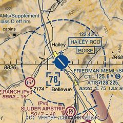
| Sectional chart |
|---|
|
 Download PDF
of official airport diagram from the FAA
| Airport distance calculator |
|---|
|
|
| Sunrise and sunset |
|---|
|
Times for 17-Jul-2026
| | Local
(UTC-6) | | Zulu
(UTC) |
|---|
| Morning civil twilight | | 05:38 | | 11:38 |
| Sunrise | | 06:13 | | 12:13 |
| Sunset | | 21:14 | | 03:14 |
| Evening civil twilight | | 21:48 | | 03:48 |
|
| Current date and time |
|---|
| Zulu (UTC) | 17-Jul-2026 07:33:23 |
|---|
| Local (UTC-6) | 17-Jul-2026 01:33:23 |
|---|
|
| METAR |
|---|
| KSUN | 170715Z AUTO 15008G14KT 10SM CLR 21/13 A3013 RMK AO2
|
|
| TAF |
|---|
| KSUN | 170520Z 1706/1812 32008KT P6SM VCSH BKN120 FM171700 15008KT P6SM VCTS FEW060 SCT100CB PROB30 1719/1801 VRB20G30KT 5SM -TSRA SCT040 BKN060CB FM180300 32008KT P6SM BKN120 AMD LTD TO CLD VIS AND WIND TIL 171300
|
|
| NOTAMs |
|---|
NOTAMs are issued by the DoD/FAA and will open in a separate window not controlled by AirNav.
|
|


