FAA INFORMATION EFFECTIVE 11 JUNE 2026
Location
| FAA Identifier: | SYM |
| Lat/Long: | 38-12-54.0000N 083-35-15.4000W
38-12.900000N 083-35.256667W
38.2150000,-83.5876111
(estimated) |
| Elevation: | 1028.4 ft. / 313.5 m (surveyed) |
| Variation: | 06W (2010) |
| From city: | 7 miles NW of MOREHEAD, KY |
| Time zone: | UTC -4 (UTC -5 during Standard Time) |
| Zip code: | 40313 |
Airport Operations
| Airport use: | Open to the public |
| Activation date: | 07/2007 |
| Control tower: | no |
| ARTCC: | INDIANAPOLIS CENTER |
| FSS: | LOUISVILLE FLIGHT SERVICE STATION |
| NOTAMs facility: | LOU (NOTAM-D service available) |
| Attendance: | MON-FRI 0800-1600, ALL SAT 1000-1600, ALL SUN 1300-1600 |
| Wind indicator: | lighted |
| Segmented circle: | yes |
| Lights: | ACTVT REIL RWY 02 & 20; PAPI RWY 02 & 20; MIRL RWY 02/20 - CTAF. |
| Beacon: | white-green (lighted land airport)
Operates sunset to sunrise. |
Airport Communications
| CTAF/UNICOM: | 122.7 |
| WX AWOS-3: | 119.95 (606-780-0279) |
- APCH/DEP SVC PRVDD BY INDIANAPOLIS ARTCC ON FREQS 124.225/360.725 (PORTSMOUTH RCAG).
Nearby radio navigation aids
| NDB name | | Hdg/Dist | | Freq | | Var | | ID |
|---|
| SECO | | 040/34.5 | | 393 | | 03W | | XYC | -..- -.-- -.-. |
Airport Services
| Fuel available: | 100LL JET-A+
100LL:FUEL SVC AVBL H24 WITH CREDIT CARD. |
| Parking: | hangars and tiedowns |
Runway Information
Runway 2/20
| Dimensions: | 5500 x 100 ft. / 1676 x 30 m |
| Surface: | asphalt, in good condition |
| Weight bearing capacity: | | PCN 16 /F/C/X/T | | Single wheel: | 43.5 | | Double wheel: | 62.0 |
|
| Runway edge lights: | medium intensity |
| RUNWAY 2 | | RUNWAY 20 |
| Latitude: | 38-12.472910N | | 38-13.326400N |
| Longitude: | 083-35.449403W | | 083-35.064252W |
| Elevation: | 1028.3 ft. | | 1010.4 ft. |
| Traffic pattern: | left | | left |
| Runway heading: | 026 magnetic, 020 true | | 206 magnetic, 200 true |
| Markings: | nonprecision, in good condition | | nonprecision, in good condition |
| Visual slope indicator: | 4-light PAPI on left (3.00 degrees glide path) | | 4-light PAPI on left (3.00 degrees glide path) |
| Runway end identifier lights: | yes | | yes |
| Touchdown point: | yes, no lights | | yes, no lights |
| Obstructions: | 56 ft. trees, 1622 ft. from runway, 647 ft. right of centerline, 25:1 slope to clear
CONTROLLING OBSTN EXCEEDS A 45 DEG SLP. | | 53 ft. trees, 216 ft. from runway, 456 ft. right of centerline |
Airport Ownership and Management from official FAA records
| Ownership: | Publicly-owned |
| Owner: | MOREHEAD-ROWAN COUNTY AIRPORT BOARD
1800 RODNEY HITCH BLVD
MOREHEAD, KY 40351
Phone (606) 776-1232
BRUCE MATTINGLY |
| Manager: | JACK & JODI HOLLEY
1800 RODNEY HITCH BLVD
MOREHEAD, KY 40351
Phone 606-780-0085
(606) 776-6211 OR (606) 356-2313. |
Additional Remarks
| - | FOR CD CTC INDIANAPOLIS ARTCC AT 317-247-2411. |
Instrument Procedures
NOTE: All procedures below are presented as PDF files. If you need a reader for these files, you should download the free Adobe Reader.NOT FOR NAVIGATION. Please procure official charts for flight.
FAA instrument procedures published for use from 11 June 2026 at 0901Z to 09 July 2026 at 0900z.
IAPs - Instrument Approach Procedures |
|---|
| RNAV (GPS) RWY 02 | |
download (239KB) |
| RNAV (GPS) RWY 20 | |
download (231KB) |
| NOTE: Special Alternate Minimums apply | |
download |
| NOTE: Special Take-Off Minimums/Departure Procedures apply | |
download |
Other nearby airports with instrument procedures:
KIOB - Mount Sterling/Montgomery County Airport (21 nm SW)
KFGX - Fleming-Mason Airport (21 nm N)
0I8 - Cynthiana-Harrison County Airport (34 nm W)
KAMT - Alexander Salamon Airport (38 nm N)
KJKL - Julian Carroll Airport (39 nm S)
|
|

Road maps at:
MapQuest
Bing
Google
| Aerial photo |
|---|
WARNING: Photo may not be current or correct
 Photo by Tim Wright
Photo taken 29-Sep-2017
looking north at 3,500 ft.
Photo by Tim Wright
Photo taken 29-Sep-2017
looking north at 3,500 ft.
Do you have a better or more recent aerial photo of Morehead-Rowan County Clyde A Thomas Regional Airport that you would like to share? If so, please send us your photo.
|
| Sectional chart |
|---|
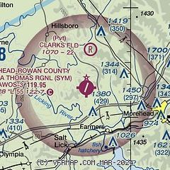
|
| Airport distance calculator |
|---|
|
|
| Sunrise and sunset |
|---|
|
Times for 19-Jun-2026
| | Local
(UTC-4) | | Zulu
(UTC) |
|---|
| Morning civil twilight | | 05:40 | | 09:40 |
| Sunrise | | 06:12 | | 10:12 |
| Sunset | | 20:59 | | 00:59 |
| Evening civil twilight | | 21:31 | | 01:31 |
|
| Current date and time |
|---|
| Zulu (UTC) | 19-Jun-2026 10:34:22 |
|---|
| Local (UTC-4) | 19-Jun-2026 06:34:22 |
|---|
|
| TAF |
|---|
| KSYM | 190524Z 1906/2006 VRB03KT P6SM SCT020 BKN040 TEMPO 1907/1911 2SM BR BKN020 FM191500 31008KT P6SM FEW035 SCT050 AMD NOT SKED
|
|
| NOTAMs |
|---|
NOTAMs are issued by the DoD/FAA and will open in a separate window not controlled by AirNav.
|
|

