FAA INFORMATION EFFECTIVE 14 MAY 2026
Location
| FAA Identifier: | U03 |
| Lat/Long: | 42-35-50.6000N 114-48-02.3000W
42-35.843333N 114-48.038333W
42.5973889,-114.8006389
(estimated) |
| Elevation: | 3662.7 ft. / 1116.4 m (surveyed) |
| Variation: | 16E (1985) |
| From city: | 2 miles W of BUHL, ID |
| Time zone: | UTC -6 (UTC -7 during Standard Time) |
| Zip code: | 83316 |
Airport Operations
| Airport use: | Open to the public |
| Activation date: | 11/1949 |
| Control tower: | no |
| ARTCC: | SALT LAKE CITY CENTER |
| FSS: | BOISE FLIGHT SERVICE STATION |
| NOTAMs facility: | BOI (NOTAM-D service available) |
| Attendance: | 0830-1700
PHONE 208-731-3781 FOR SVC WHEN ARPT UNATTENDED. |
| Wind indicator: | lighted |
| Segmented circle: | yes |
| Lights: | ACTVT MIRL RY 09/27 - CTAF. |
| Beacon: | white-green (lighted land airport)
Operates sunset to sunrise. |
Airport Communications
| CTAF: | 122.9 |
| WX ASOS at TWF (15 nm SE): | 135.025 (208-733-1878) |
| WX ASOS at JER (17 nm NE): | 135.225 (208-324-7076) |
| WX AWOS-3PT at GNG (19 nm N): | 124.175 (208 934 4950) |
Nearby radio navigation aids
| VOR radial/distance | | VOR name | | Freq | | Var |
|---|
| TWFr279/15.5 | | TWIN FALLS VORTAC | | 113.10 | | 18E |
Airport Services
| Fuel available: | 100LL MOGAS |
| Parking: | tiedowns |
| Airframe service: | MAJOR |
| Powerplant service: | MAJOR |
| Bottled oxygen: | NONE |
| Bulk oxygen: | NONE |
Runway Information
Runway 9/27
| Dimensions: | 3898 x 60 ft. / 1188 x 18 m |
| Surface: | asphalt, in good condition |
| Weight bearing capacity: | |
| Runway edge lights: | medium intensity |
| RUNWAY 9 | | RUNWAY 27 |
| Latitude: | 42-35.946103N | | 42-35.741855N |
| Longitude: | 114-48.449127W | | 114-47.625937W |
| Elevation: | 3608.8 ft. | | 3662.7 ft. |
| Traffic pattern: | left | | left |
| Runway heading: | 093 magnetic, 109 true | | 273 magnetic, 289 true |
| Markings: | basic, in good condition | | basic, in good condition |
| Touchdown point: | yes, no lights | | yes, no lights |
| Obstructions: | 5 ft. fence, 300 ft. from runway, 20:1 slope to clear
5 FT BARB WIRE FENCE AT 100 FT ON CNTRLN. | | 15 ft. road, 525 ft. from runway, 21:1 slope to clear |
Airport Ownership and Management from official FAA records
| Ownership: | Publicly-owned |
| Owner: | CITY OF BUHL
203 BROADWAY NORTH
BUHL, ID 83316
Phone 208-543-5650 |
| Manager: | NEIL RING
203 BROADWAY NORTH
BUHL, ID 83316
Phone 208-961-6539 |
Additional Remarks
| - | NO LIGHTS, ONLY REFLECTORS ON PARL TWY. |
| - | FOR CD CTC TWIN FALLS APCH AT 208-734-7160, WHEN APCH CLSD CTC SALT LAKE ARTCC AT 801-320-2568. |
| - | RWY 27 +15 FT DIRT PILES, HEAVY EQPT AND SEMI TRAILERS PARKED AT 900 FT ON CNTRLN. |
| - | CTN: FOR CLOSE-IN/SHORT FINAL OPS FOR RWY 27, BE AWARE OF 20 FT PWR POLE AT 525 FT, 150 FT RT. |
Instrument Procedures
There are no published instrument procedures at U03.
Some nearby airports with instrument procedures:
KTWF - Joslin Field/Magic Valley Regional Airport (15 nm SE)
KJER - Jerome County Airport (17 nm NE)
KGNG - Gooding Municipal Airport (19 nm N)
KBYI - Burley Municipal Airport (46 nm E)
U76 - Mountain Home Municipal Airport (52 nm NW)
|
|

Road maps at:
MapQuest
Bing
Google
| Aerial photo |
|---|
WARNING: Photo may not be current or correct
 Photo taken 06-Jul-2006
Do you have a better or more recent aerial photo of Buhl Municipal Airport that you would like to share? If so, please send us your photo.
|
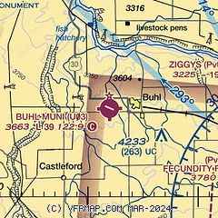
| Sectional chart |
|---|
|
| Airport distance calculator |
|---|
|
|
| Sunrise and sunset |
|---|
|
Times for 15-May-2026
| | Local
(UTC-6) | | Zulu
(UTC) |
|---|
| Morning civil twilight | | 05:46 | | 11:46 |
| Sunrise | | 06:18 | | 12:18 |
| Sunset | | 20:53 | | 02:53 |
| Evening civil twilight | | 21:26 | | 03:26 |
|
| Current date and time |
|---|
| Zulu (UTC) | 16-May-2026 05:12:02 |
|---|
| Local (UTC-6) | 15-May-2026 23:12:02 |
|---|
|
| METAR |
|---|
KTWF
16nm SE | 160453Z AUTO 18006KT 10SM CLR 08/M04 A2997 RMK AO2 SLP118 T00831039
|
KJER
17nm NE | 160453Z AUTO 12006KT 10SM CLR 11/M02 A2996 RMK AO2 SLP128 T01111017
|
KGNG
19nm N | 160455Z AUTO 25005KT 10SM FEW048 12/M05 A2996 RMK AO2
|
|
| TAF |
|---|
KTWF
16nm SE | 151723Z 1518/1618 30015G25KT P6SM SKC FM160200 20010KT P6SM SCT150 FM161200 26015G25KT P6SM OVC120
|
KJER
17nm NE | 151723Z 1518/1618 26017G27KT P6SM FEW250 FM160300 VRB05KT P6SM SCT150 FM160600 16005KT P6SM BKN150 FM161200 27020G30KT P6SM OVC100
|
|
| NOTAMs |
|---|
NOTAMs are issued by the DoD/FAA and will open in a separate window not controlled by AirNav.
|
|

