FAA INFORMATION EFFECTIVE 16 APRIL 2026
Location
| FAA Identifier: | W05 |
| Lat/Long: | 39-50-28.7130N 077-16-28.7400W
39-50.478550N 077-16.479000W
39.8413092,-77.2746500
(estimated) |
| Elevation: | 553.2 ft. / 168.6 m (surveyed) |
| Variation: | 11W (2010) |
| From city: | 2 miles W of GETTYSBURG, PA |
| Time zone: | UTC -4 (UTC -5 during Standard Time) |
| Zip code: | 17325 |
Airport Operations
| Airport use: | Open to the public |
| Activation date: | 07/1973 |
| Control tower: | no |
| ARTCC: | WASHINGTON CENTER |
| FSS: | WILLIAMSPORT FLIGHT SERVICE STATION |
| NOTAMs facility: | IPT (NOTAM-D service available) |
| Attendance: | UNATNDD |
| Wind indicator: | lighted |
| Segmented circle: | yes |
| Lights: | ACTVT MIRL RWY 06/24 - CTAF. |
| Beacon: | white-green (lighted land airport)
Operates sunset to sunrise. |
Airport Communications
| CTAF: | 122.9 |
| POTOMAC APPROACH: | 126.825 |
| POTOMAC DEPARTURE: | 126.825 |
| WX AWOS-3 at DMW (19 nm SE): | 121.25 (410-876-1281) |
| WX AWOS-3 at N68 (19 nm NW): | 120.725 (717-261-1943) |
| WX ASOS at THV (19 nm E): | 119.275 (717-792-5529) |
Nearby radio navigation aids
| VOR radial/distance | | VOR name | | Freq | | Var |
|---|
| EMIr335/24.9 | | WESTMINSTER VORTAC | | 117.90 | | 08W |
| FDKr018/26.2 | | FREDERICK VOR/DME | | 116.85 | | 08W |
| HGRr079/(28.1) | | HAGERSTOWN VOR | | 109.80 | | 07W |
| HARr209/29.2 | | HARRISBURG VORTAC | | 115.35 | | 10W |
| MRBr051/38.1 | | MARTINSBURG VORTAC | | 112.10 | | 07W |
Airport Services
| Fuel available: | 100LL |
| Parking: | tiedowns |
| Airframe service: | MAJOR |
| Powerplant service: | MAJOR |
Runway Information
Runway 6/24
| Dimensions: | 3100 x 60 ft. / 945 x 18 m |
| Surface: | asphalt, in good condition |
| Runway edge lights: | medium intensity |
| RUNWAY 6 | | RUNWAY 24 |
| Latitude: | 39-50.312825N | | 39-50.644270N |
| Longitude: | 077-16.730955W | | 077-16.227013W |
| Elevation: | 539.8 ft. | | 552.3 ft. |
| Traffic pattern: | left | | left |
| Runway heading: | 061 magnetic, 050 true | | 241 magnetic, 230 true |
| Displaced threshold: | 165 ft. | | 539 ft. |
| Markings: | nonprecision, in good condition | | basic, in good condition |
| Touchdown point: | yes, no lights | | yes, no lights |
| Obstructions: | 14 ft. road, 370 ft. from runway, 11:1 slope to clear
APCH RATIO 26:1 TO DTHR. | | 51 ft. pole, marked, 749 ft. from runway, 118 ft. right of centerline, 10:1 slope to clear
RWY 24 APCH RATIO 21:1 TO DSPLCD THLD. |
Airport Ownership and Management from official FAA records
| Ownership: | Publicly-owned |
| Owner: | SUSQUEHANNA RGNL ARPT AUTHORITY
ONE TERMINAL DRIVE, SUITE 300
MIDDLETOWN, PA 17057
Phone 717-948-3900 |
| Manager: | TIM EDWARDS
ONE TERMINAL DRIVE, SUITE 300
MIDDLETOWN, PA 17057
Phone 717-948-3900 |
Additional Remarks
| - | DEER AND BIRDS INVOF ARPT. |
| - | FOR CD CTC POTOMAC APCH AT 866-709-4993. |
Instrument Procedures
NOTE: All procedures below are presented as PDF files. If you need a reader for these files, you should download the free Adobe Reader.NOT FOR NAVIGATION. Please procure official charts for flight.
FAA instrument procedures published for use from 16 April 2026 at 0901Z to 14 May 2026 at 0900Z.
IAPs - Instrument Approach Procedures |
|---|
| RNAV (GPS) RWY 06 | |
download (213KB) |
| RNAV (GPS)-A | |
download (169KB) |
| NOTE: Special Take-Off Minimums/Departure Procedures apply | |
download (209KB) |
Other nearby airports with instrument procedures:
KDMW - Carroll County Regional Airport/Jack B Poage Field (19 nm SE)
N68 - Franklin County Regional Airport (19 nm NW)
KTHV - York Airport (19 nm E)
N94 - Carlisle Airport (21 nm N)
KHGR - Hagerstown Regional Airport-Richard A Henson Field (22 nm W)
|
|

Road maps at:
MapQuest
Bing
Google
| Aerial photo |
|---|
WARNING: Photo may not be current or correct
 Photo by Dale Hartman
Photo taken 28-Sep-2013
looking southwest.
Photo by Dale Hartman
Photo taken 28-Sep-2013
looking southwest.
Do you have a better or more recent aerial photo of Gettysburg Regional Airport that you would like to share? If so, please send us your photo.
|
| Sectional chart |
|---|
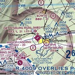
|
| Airport distance calculator |
|---|
|
|
| Sunrise and sunset |
|---|
|
Times for 02-May-2026
| | Local
(UTC-4) | | Zulu
(UTC) |
|---|
| Morning civil twilight | | 05:40 | | 09:40 |
| Sunrise | | 06:09 | | 10:09 |
| Sunset | | 20:03 | | 00:03 |
| Evening civil twilight | | 20:32 | | 00:32 |
|
| Current date and time |
|---|
| Zulu (UTC) | 02-May-2026 09:31:42 |
|---|
| Local (UTC-4) | 02-May-2026 05:31:42 |
|---|
|
| METAR |
|---|
KTHV
19nm E | 020853Z AUTO 29007KT 10SM SCT100 07/03 A2992 RMK AO2 SLP133 60001 T00720033 53002
|
KDMW
19nm SE | 020855Z AUTO 31012G17KT 10SM OVC090 09/04 A2992 RMK AO2
|
|
| TAF |
|---|
KMDT
32nm NE | 020540Z 0206/0306 29005KT 6SM -SHRA OVC040 FM020800 31009KT P6SM SCT050 BKN250 FM021200 32009KT P6SM BKN250 FM022100 31007KT P6SM BKN050 FM030400 28005KT P6SM SCT050
|
|
| NOTAMs |
|---|
NOTAMs are issued by the DoD/FAA and will open in a separate window not controlled by AirNav.
|
|


