FAA INFORMATION EFFECTIVE 09 JULY 2026
Location
| FAA Identifier: | WBW |
| Lat/Long: | 41-17-50.3070N 075-51-08.0760W
41-17.838450N 075-51.134600W
41.2973075,-75.8522433
(estimated) |
| Elevation: | 543.8 ft. / 165.8 m (surveyed) |
| Variation: | 12W (1990) |
| From city: | 3 miles N of WILKES-BARRE, PA |
| Time zone: | UTC -4 (UTC -5 during Standard Time) |
| Zip code: | 18644 |
Airport Operations
| Airport use: | Open to the public |
| Control tower: | no |
| ARTCC: | NEW YORK CENTER |
| FSS: | WILLIAMSPORT FLIGHT SERVICE STATION |
| NOTAMs facility: | IPT (NOTAM-D service available) |
| Attendance: | 0800-1700 |
| Wind indicator: | yes |
| Segmented circle: | yes |
| Lights: | ACTVT PAPI RWY 07/25; MIRL RWY 07/25 - CTAF. RWY 07/25 PRESET LOW INTST TO ACTVT HIGHER INTST - CTAF. |
| Beacon: | white-green (lighted land airport)
ACTVT ROTG BCN - CTAF. |
Airport Communications
| CTAF/UNICOM: | 122.8 |
| WILKES-BARRE APPROACH: | 126.3 |
| WILKES-BARRE DEPARTURE: | 126.3 |
| WX ASOS at AVP (6 nm NE): | PHONE 570-456-5433 |
| WX AWOS-3 at HZL (20 nm S): | 119.975 (570-459-4901) |
Nearby radio navigation aids
| VOR radial/distance | | VOR name | | Freq | | Var |
|---|
| LVZr291/7.5 | | WILKES-BARRE VORTAC | | 111.60 | | 10W |
| FJCr342/38.7 | | ALLENTOWN VORTAC | | 117.50 | | 10W |
Airport Services
| Fuel available: | 100LL JET-A |
| Parking: | hangars and tiedowns |
| Airframe service: | MAJOR |
| Powerplant service: | MAJOR |
| Bottled oxygen: | NONE |
| Bulk oxygen: | NONE |
Runway Information
Runway 7/25
| Dimensions: | 3375 x 75 ft. / 1029 x 23 m |
| Surface: | asphalt, in good condition |
| Runway edge lights: | medium intensity |
| RUNWAY 7 | | RUNWAY 25 |
| Latitude: | 41-17.665447N | | 41-17.995363N |
| Longitude: | 075-51.369045W | | 075-50.775940W |
| Elevation: | 543.8 ft. | | 542.9 ft. |
| Traffic pattern: | left | | left |
| Runway heading: | 066 magnetic, 054 true | | 246 magnetic, 234 true |
| Markings: | nonprecision, in good condition | | nonprecision, in good condition |
| Visual slope indicator: | 2-light PAPI on left (4.00 degrees glide path) | | 2-light PAPI on left (3.75 degrees glide path) |
| Runway end identifier lights: | no | | no |
| Touchdown point: | yes, no lights | | yes, no lights |
| Obstructions: | none | | 120 ft. tree, 2286 ft. from runway, 528 ft. right of centerline, 17:1 slope to clear |
Runway 9/27
| Dimensions: | 2193 x 100 ft. / 668 x 30 m
RWY 09/27 FIRST 544 FT RWY 27 ASPH, RMNDR TURF. |
| Surface: | asphalt/turf, in good condition |
| Runway edge markings: | RWY 09/27 MKD WITH 3 FT WHITE CONES. RWY 09; DSPLCD THLD MKD WITH THREE WHITE CONES EACH SIDE. |
| Operational restrictions: | RWY 09/27 CLSD WINTER MONTHS. |
| RUNWAY 9 | | RUNWAY 27 |
| Latitude: | 41-17.810765N | | 41-17.890880N |
| Longitude: | 075-51.463625W | | 075-50.996723W |
| Elevation: | 541.2 ft. | | 542.5 ft. |
| Traffic pattern: | left | | left |
| Runway heading: | 089 magnetic, 077 true | | 269 magnetic, 257 true |
| Displaced threshold: | 672 ft. | | no |
| Markings: | , in good condition | | , in good condition |
| Touchdown point: | yes, no lights | | yes, no lights |
| Obstructions: | 94 ft. trees, 1107 ft. from runway, 136 ft. left of centerline, 11:1 slope to clear
APCH RATIO 18:1 TO DTHR. | | none |
Airport Ownership and Management from official FAA records
| Ownership: | Publicly-owned |
| Owner: | COUNTY OF LUZERNE
200 N. RIVER ST.
WILKES-BARRE, PA 18071
Phone 570-825-1600 |
| Manager: | JIM SCROBOLA
2001 WYOMING AVE
FORTY FORT, PA 18704
Phone 570-288-3257 |
Additional Remarks
| - | +152 FT TRANSMISSION LINES 6000 FT FROM RWY 25 THLD 585 FT L MKD WITH RED SPHERES. |
| - | FOR CD CTC WILKES-BARRE APCH AT 570-655-2084. |
Instrument Procedures
NOTE: All procedures below are presented as PDF files. If you need a reader for these files, you should download the free Adobe Reader.NOT FOR NAVIGATION. Please procure official charts for flight.
FAA instrument procedures published for use from 09 July 2026 at 0901Z to 06 August 2026 at 0900Z.
IAPs - Instrument Approach Procedures |
|---|
| RNAV (GPS) RWY 07 | |
download (233KB) |
| RNAV (GPS) RWY 25 | |
download (246KB) |
| NOTE: Special Take-Off Minimums/Departure Procedures apply | |
download (149KB) |
Other nearby airports with instrument procedures:
KAVP - Wilkes-Barre/Scranton International Airport (6 nm NE)
9N3 - Seamans Field Airport (18 nm N)
KHZL - Hazleton Regional Airport (20 nm S)
KMPO - Pocono Mountains Regional Airport (23 nm SE)
22N - Jake Arner Memorial Airport (30 nm S)
|
|

Road maps at:
MapQuest
Bing
Google
| Aerial photo |
|---|
WARNING: Photo may not be current or correct
 Photo by Karl Rittinger
Photo taken 10-May-2011
looking east.
Photo by Karl Rittinger
Photo taken 10-May-2011
looking east.
Do you have a better or more recent aerial photo of Wilkes-Barre Wyoming Valley Airport that you would like to share? If so, please send us your photo.
|
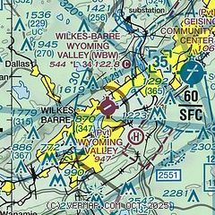
| Sectional chart |
|---|
|
| Airport distance calculator |
|---|
|
|
| Sunrise and sunset |
|---|
|
Times for 30-Jul-2026
| | Local
(UTC-4) | | Zulu
(UTC) |
|---|
| Morning civil twilight | | 05:26 | | 09:26 |
| Sunrise | | 05:58 | | 09:58 |
| Sunset | | 20:22 | | 00:22 |
| Evening civil twilight | | 20:53 | | 00:53 |
|
| Current date and time |
|---|
| Zulu (UTC) | 30-Jul-2026 12:37:51 |
|---|
| Local (UTC-4) | 30-Jul-2026 08:37:51 |
|---|
|
| METAR |
|---|
KAVP
6nm E | 301154Z 04007KT 10SM OVC016 18/17 A2981 RMK AO2 SLP087 60017 70034 T01830167 10189 20178 53022
|
KHZL
20nm S | 301155Z AUTO 32004KT 3SM -DZ OVC004 17/16 A2984 RMK AO2 P0001
|
|
| TAF |
|---|
KAVP
6nm E | 301120Z 3012/3112 34008KT P6SM OVC015 FM301700 35009G15KT P6SM BKN035 FM302000 36008G15KT P6SM SCT035 FM310200 00000KT P6SM SCT040
|
|
| NOTAMs |
|---|
NOTAMs are issued by the DoD/FAA and will open in a separate window not controlled by AirNav.
|
|

