FAA INFORMATION EFFECTIVE 18 APRIL 2024
Location
| FAA Identifier: | WRI |
| Lat/Long: | 40-00-56.1007N 074-35-30.1169W
40-00.935012N 074-35.501948W
40.0155835,-74.5916991
(estimated) |
| Elevation: | 140.5 ft. / 42.8 m (surveyed) |
| Variation: | 12W (1985) |
| From city: | 2 miles SE of WRIGHTSTOWN, NJ |
| Time zone: | UTC -4 (UTC -5 during Standard Time) |
| Zip code: | 08641 |
Airport Operations
| Airport use: | Private use. Permission required prior to landing |
| Activation date: | 02/1938 |
| Control tower: | yes |
| ARTCC: | NEW YORK CENTER |
| FSS: | NEW YORK FLIGHT SERVICE STATION |
| NOTAMs facility: | WRI (NOTAM-D service available) |
| Attendance: | CONTINUOUS |
| Pattern altitude: | TPA FOR HEL 600 FT; LGT ACFT 800 FT; RECTANGULAR 1600 FT; OHD 2100 FT. |
| Wind indicator: | yes |
| Segmented circle: | no |
| Beacon: | white-green (lighted land airport)
Operates sunset to sunrise. |
| International operations: | customs landing rights airport |
Airport Communications
| MC GUIRE GROUND: | 121.8 275.8 |
| MC GUIRE TOWER: | 118.65 255.6 257.8 |
| MC GUIRE APPROACH: | 126.475 363.8 388.2 |
| MC GUIRE DEPARTURE: | 126.475 363.8 |
| CLEARANCE DELIVERY: | 135.2 335.8 |
| ARMY OPS: | 36.3FM |
| COMD POST: | 134.1 237.15 251.2 ;108 ANG CALL TORCH CONTROL 321.0 ;108 ANG CALL TORCH CONTROL |
| D-ATIS: | 110.6 270.1 |
| EMERG: | 121.5 243.0 |
| HARRISBURG STAR: | 126.475 363.8 |
| PMSV METRO: | 239.8 |
| RANGE CTL: | 34.3FM |
| SFA: | 372.2 |
| WAALK STAR: | 126.475 363.8 |
| WX ASOS at VAY (12 nm W): | 119.325 (609-267-1176) |
| WX AWOS-3PT at MJX (15 nm E): | 119.875 (732-797-2542) |
| WX ASOS at TTN (19 nm NW): | 126.775 (609-538-8690) |
| WX AWOS-AV at N12 (19 nm E): | 122.8 (732-363-6471) |
| WX ASOS at PNE (20 nm W): | PHONE 215-677-0146 |
- TSNT ACFT CTC FORT DIX OPNS PRIOR TO LNDG.
- (ATIS PHONE NR) DSN 650-2847.
- USE 237.15 WITHIN 75 NM ARPT. IF 237.15 IS INOP USE 134.1 (CALL BRICKYARD).
Nearby radio navigation aids
| VOR radial/distance | | VOR name | | Freq | | Var |
|---|
| GXU at field | | MC GUIRE VORTAC | | 110.60 | | 12W |
| RBVr212/12.1 | | ROBBINSVILLE VORTAC | | 113.80 | | 10W |
| CYNr338/14.0 | | COYLE VORTAC | | 113.40 | | 10W |
| ARDr145/20.3 | | YARDLEY VOR/DME | | 108.20 | | 10W |
| COLr239/26.6 | | COLTS NECK VOR/DME | | 115.40 | | 11W |
| VCNr041/33.5 | | CEDAR LAKE VOR/DME | | 115.20 | | 10W |
| ACYr009/33.6 | | ATLANTIC CITY VORTAC | | 117.15 | | 10W |
| SBJr179/34.7 | | SOLBERG VOR/DME | | 112.90 | | 10W |
| OODr065/39.9 | | WOODSTOWN VORTAC | | 112.80 | | 10W |
| NDB name | | Hdg/Dist | | Freq | | Var | | ID |
|---|
| LAKEHURST | | 273/11.9 | | 396 | | 11W | | NEL | -. . .-.. |
Airport Services
| Parking: | hangars |
| Airframe service: | MAJOR |
| Powerplant service: | MAJOR |
| Bottled oxygen: | NONE |
| Bulk oxygen: | HIGH/LOW |
Runway Information
Runway 6/24
| Dimensions: | 10014 x 150 ft. / 3052 x 46 m |
| Surface: | asphalt/concrete/grooved
FIRST 1000 FT OF RWYS 06 AND 24 ARE GROOVED CONC; REMAINDER OF RWY GROOVED ASPHALT. RWY 06/24 HAS HARDENED AND NON-GROOVED OVERRUNS. |
| Weight bearing capacity: | |
| Runway edge lights: | high intensity |
| Operational restrictions: | RWY 06/24 UNDER RUNS AVBL FOR DEP. |
| RUNWAY 6 | | RUNWAY 24 |
| Latitude: | 40-00.265578N | | 40-01.416133N |
| Longitude: | 074-35.852725W | | 074-34.315767W |
| Elevation: | 131.2 ft. | | 103.1 ft. |
| Traffic pattern: | left | | right |
| Runway heading: | 057 magnetic, 045 true | | 237 magnetic, 225 true |
| Markings: | precision | | precision |
| Visual slope indicator: | 4-light PAPI on left (3.00 degrees glide path) | | 4-light PAPI on left (3.00 degrees glide path) |
| RVR equipment: | touchdown, midfield, rollout | | touchdown, rollout |
| Approach lights: | ALSF2: standard 2,400 foot high intensity approach lighting system with centerline sequenced flashers (category II or III) | | ALSF1: standard 2,400 foot high intensity approach lighting system with centerline sequenced flashers (category I) |
| Runway end identifier lights: | no | | no |
| Centerline lights: | yes | | yes |
| Touchdown point: | yes, lighted | | yes, no lights |
| Instrument approach: | ILS | | LOC/GS |
Runway 18/36
| Dimensions: | 7126 x 150 ft. / 2172 x 46 m |
| Surface: | concrete
FIRST 431 FT RWY 36 CONC, REMAINING 6695 FT ASPHALT. |
| Weight bearing capacity: | |
| Runway edge lights: | high intensity |
| RUNWAY 18 | | RUNWAY 36 |
| Latitude: | 40-01.649527N | | 40-00.485123N |
| Longitude: | 074-36.184925W | | 074-35.992917W |
| Elevation: | 122.0 ft. | | 128.5 ft. |
| Traffic pattern: | right | | left |
| Runway heading: | 185 magnetic, 173 true | | 005 magnetic, 353 true |
| Markings: | nonprecision | | nonprecision |
| Visual slope indicator: | 4-light PAPI on left (3.00 degrees glide path) | | 4-light PAPI on left (3.00 degrees glide path) |
| RVR equipment: | touchdown, rollout | | touchdown, rollout |
| Runway end identifier lights: | yes | | yes |
| Touchdown point: | yes, no lights | | yes, no lights |
Airport Ownership and Management from official FAA records
| Ownership: | U.S. Air Force |
| Owner: | USAF JB MCGUIRE DIX LAKEHURST
2901 FALCON LANE
MCGUIRE, NJ 08641
Phone 609-754-2714 |
| Manager: | CHIEF AIRFIELD MANAGEMENT
2901 FALCON LANE
MCGUIRE, NJ 08641
Phone 609-754-6466 |
Additional Remarks
| A58-18 | PLINE 45 FT HI & 3/4 MI FM APCH END 18. |
| - | SERVICE: AOE. |
| - | RSTD: ALL INBD PAX/CARGO ACFT CTC COMD POST NO LATER THAN 30 MIN PRIOR TO LDG. |
| - | CAUTION: RWY 18/36 LANDING ZONE MARKINGS MID-FIELD. |
| - | JASU: (C26) (MD-3) 6(MA-1A) (MA-1). |
| - | REMARK: 72 HR PPR FOR ARMY RAMP AND LDG ALL ICTN ON FT DIX RESERVATION DSN 562-6377/5287. |
| - | RWY 18/36 ONLY HAS 200 FT PAVED ASPHALT NON-GROOVED OVERRUNS, REMAINDER OF RWY NOT GROOVED. |
| - | ASA RAMP OPR 1230-2130Z WKD. WKEND HR BY PRIOR APVL. FAC LCTD ON SW SIDE OF AFLD. 72 HR PPR FOR ARMY RAMP AND LDG ALL LCTN ON FT DIX RESERVAION DSN 562-3451, CELL 609-649-3743. TRAN ACFT CTC ARMY OPS PRIOR TO LDG. |
| - | FUEL: A++ |
| - | MISC: ALL CLASSIFIED MATERIAL MUST BE STORED AT THE JB COMD POST DSN 650-3935/3936. AFLD MGMT HAS NO CLASSIFIED STORAGE CAPABILITIES. |
| - | MISC: FIRST 431 FT RWY 36 CONC REMAINING 6695 FT ASPH. |
| - | CAUTION: NSTD MRK ON VICTOR ROW FOR ALERT MSN, X-RAY ROW (PRIM), AND ROMEO ROW (ALTN) FOR COMBAT OFF LOAD OPS. |
| - | FLUID: SP PRESAIR LHOX LOX (C-5, KC-10, 747 DE-ICING LTD TO WG ONLY. 3 HR PN RQR.) |
| - | OIL: O-128-133-148-156. |
| - | SERVICE-LGT: RWY 18 PAR AND PAPI NOT COINCIDENTAL. |
| - | 180 DEG TURNS RSTD TO CONC PORTIONS OF RWYS ONLY. |
| - | ASA RAMP OPR 1230-2130++. |
| - | RWY COND CODES (RWYCC) UNAVBL. |
| - | TRAN ALERT: SVC AVBL H24 DLY. |
| - | RSTD: TRAN ACFT RQR CUST MUST COORD WITH AIRFIELD MGMT AT TIME OF PPR REQ. |
| - | AN/FMQ-19 AUTOMATED OBSERVING SYS IN USE, AUGMENTED BY HUMAN OBS WHEN NEC DURG AIRFIELD HRS. VIS OF AIRFIELD RSTR FR BASE WX OPS NW-SE DURG MAN AUGMENTATION BY WX FORECASTER. WX SVC AVBL H24. WX FLT DSN 650-1130, C609-754-1130. WHEN WX SVC CLSD, TRAN CREWS CTC 15 OPR WX SQDN (OWS) AT SCOTT AFB H24 DSN 576-9755/9702, C618-256-9755/9702. DURG EVAC OF WX FLT CTC 15OWS AT NR ABV. RON TRAN CREW RQR WX BRIEF PRIOR TO LDG ATC WILL SUPPL OBS AS NEEDED. |
| - | MISC: ALL TRAN ACFT RQR PPR. REQ APVL THRU AFLD MGMT OPS DSN 650-2714, C609-754-2714; PPRS WILL BE REQ NO EARLIER THAN SEVEN DAYS, AND NO LATER THAN 24 HR PRIOR TO ARR, 48 HR FOR ACFT CARRYING DANGEROUS/HAZ CARGO. AIRCREWS WITH APV PPR THAT DEVIATE FROM COORD ARR TIME BY MORE THAN ONE HR MUST NOTIFY AMOPS ASAP. IF NO NOTIFICATION RCVD AFTER ONE HR, PPR WILL BE TERMINATED. |
| - | RSTD: DUR BASH PHASE II, ONE-TIME DEP/ARR AUTH'D +/- 1 HR SR/SS UNDER REAL-TIME BWC. REAL-TIME BWC CAN ONLY BE DETERMINED WHEN THE FLD COND ARE AT LEAST 3000 FT/5 STATUTE MILES AND IF TWR CAN VISUALLY CONFIRM A BWC LESS THAN SEVERE. TKOFF AND LDG ARE NOT AUTHORIZED UNLESS APV BY 305 OG/CC FOR 305 AMW, AND USAF TRAN ACFT OR OPS GP COMDR SVC EQUIVALENT FOR TENANT UNITS. ALFA ALERT ACFT ARE EXEMPT FROM THIS REQUIREMENT. COORD WAIVERS THRU COMD POST. |
Instrument Procedures
NOTE: All procedures below are presented as PDF files. If you need a reader for these files, you should download the free Adobe Reader.NOT FOR NAVIGATION. Please procure official charts for flight.
FAA instrument procedures published for use from 18 April 2024 at 0901Z to 16 May 2024 at 0900Z.
STARs - Standard Terminal Arrivals |
|---|
| HARRISBURG FIVE | |
download (193KB) |
| WAALK TWO (RNAV) **CHANGED** | |
2 pages:
[1] [2] (288KB) |
IAPs - Instrument Approach Procedures |
|---|
| ILS OR LOC RWY 06 | |
download (173KB) |
| ILS OR LOC RWY 24 | |
download (104KB) |
| ILS RWY 06 (CAT II) | |
download (149KB) |
| RNAV (RNP) Z RWY 24 | |
download (188KB) |
| RNAV (GPS) RWY 06 | |
download (91KB) |
| RNAV (GPS) RWY 18 | |
download (78KB) |
| RNAV (GPS) RWY 24 | |
download (98KB) |
| RNAV (GPS) RWY 36 | |
download (79KB) |
| VOR/DME OR TACAN RWY 06 | |
download (147KB) |
| VOR/DME OR TACAN RWY 18 | |
download (148KB) |
| VOR/DME OR TACAN RWY 24 | |
download (114KB) |
| VOR/DME OR TACAN RWY 36 | |
download (132KB) |
| Radar Approach Procedures available | |
download (64KB) |
Departure Procedures |
|---|
| MANTA TWO (RNAV) | |
download (56KB) |
| NAGGS TWO (RNAV) | |
download (150KB) |
| THMAS TWO (RNAV) | |
download (106KB) |
| NOTE: Special Take-Off Minimums/Departure Procedures apply | |
download (249KB) |
Other nearby airports with instrument procedures:
N14 - Flying W Airport (11 nm SW)
KNEL - Lakehurst Maxfield Field Airport (11 nm E)
N87 - Trenton-Robbinsville Airport (12 nm N)
KVAY - South Jersey Regional Airport (12 nm W)
KMJX - Ocean County Airport (15 nm E)
KTTN - Trenton Mercer Airport (19 nm NW)
N12 - Lakewood Airport (19 nm E)
KPNE - Northeast Philadelphia Airport (20 nm W)
|
|

Road maps at:
MapQuest
Bing
Google
| Aerial photo |
|---|
WARNING: Photo may not be current or correct
 Photo by Brian Corley
Photo taken 02-May-2015
looking northeast.
Photo by Brian Corley
Photo taken 02-May-2015
looking northeast.
Do you have a better or more recent aerial photo of McGuire Field (Joint Base Mc Guire Dix Lakehurst) Airport that you would like to share? If so, please send us your photo.
|
| Sectional chart |
|---|
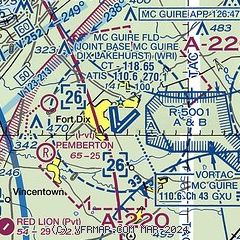
|
 Download PDF
of official airport diagram from the FAA
| Airport distance calculator |
|---|
|
|
| Sunrise and sunset |
|---|
|
Times for 24-Apr-2024
| | Local
(UTC-4) | | Zulu
(UTC) |
|---|
| Morning civil twilight | | 05:38 | | 09:38 |
| Sunrise | | 06:07 | | 10:07 |
| Sunset | | 19:46 | | 23:46 |
| Evening civil twilight | | 20:14 | | 00:14 |
|
| Current date and time |
|---|
| Zulu (UTC) | 24-Apr-2024 17:07:36 |
|---|
| Local (UTC-4) | 24-Apr-2024 13:07:36 |
|---|
|
| METAR |
|---|
| KWRI | 241655Z AUTO 28013G17KT 10SM SCT060 SCT075 20/05 A2985 RMK AO2 SLP108 T02010053
|
KNEL
12nm E | 241700Z AUTO 28015G23KT BKN060 BKN110 21/06 A2984 RMK AO2 SLP103 T02110061 $
|
KVAY
12nm SW | ASOS 119.325 609-267-1176
241654Z AUTO 28008G15KT 10SM FEW060 SCT070 BKN085 20/06 A2987 RMK AO2 SLP114 T02000061
|
KMJX
15nm E | AWOS-3 119.875 732-244-4450
241656Z AUTO 30014G23KT 10SM FEW050 22/06 A2986 RMK AO2 SLP116 T02170056
|
KTTN
19nm NW | ASOS 133.70 609-538-8690
241653Z 31011G18KT 10SM FEW060 19/06 A2985 RMK AO2 SLP101 T01890056
|
KPNE
20nm W | 241654Z 31011KT 10SM SCT060 20/05 A2987 RMK AO2 SLP116 T02000050
|
|
| TAF |
|---|
| KWRI | 241208Z 2412/2516 20008KT 9999 VCSH SCT060 BKN100 QNH2984INS BECMG 2413/2414 26012G20KT 9999 NSW FEW040 BKN070 QNH2985INS TEMPO 2414/2418 27015G25KT BECMG 2421/2422 32010G18KT 9999 BKN050 QNH2990INS BECMG 2501/2502 36010KT 9999 SCT050 QNH3006INS BECMG 2513/2514 04010KT 9999 SKC QNH3035INS TX21/2420Z TN04/2510Z
|
KTTN
19nm NW | 241120Z 2412/2512 23006KT P6SM SCT070 OVC080 FM241500 29010G18KT P6SM VCSH FEW040 BKN070 FM250000 33009KT P6SM FEW040 SCT110
|
KPNE
20nm W | 241120Z 2412/2512 24007KT P6SM SCT060 OVC090 FM241500 29010G18KT P6SM VCSH FEW040 BKN070 FM250100 31010KT P6SM FEW040 SCT110
|
|
| NOTAMs |
|---|
NOTAMs are issued by the DoD/FAA and will open in a separate window not controlled by AirNav.
|
|

