FAA INFORMATION EFFECTIVE 18 APRIL 2024
Location
| FAA Identifier: | OKC |
| Lat/Long: | 35-23-35.0665N 097-36-02.7422W
35-23.584442N 097-36.045703W
35.3930740,-97.6007617
(estimated) |
| Elevation: | 1295.8 ft. / 395.0 m (surveyed) |
| Variation: | 04E (2020) |
| From city: | 6 miles SW of OKLAHOMA CITY, OK |
| Time zone: | UTC -5 (UTC -6 during Standard Time) |
| Zip code: | 73179 |
Airport Operations
| Airport use: | Open to the public |
| Activation date: | 12/1938 |
| Control tower: | yes |
| ARTCC: | FORT WORTH CENTER |
| FSS: | MC ALESTER FLIGHT SERVICE STATION |
| NOTAMs facility: | OKC (NOTAM-D service available) |
| Attendance: | CONTINUOUS |
| Wind indicator: | lighted |
| Segmented circle: | no |
| Lights: | SS-SR |
| Beacon: | white-green (lighted land airport)
Operates sunset to sunrise. |
| Fire and rescue: | ARFF index C |
| International operations: | customs landing rights airport |
Airport Communications
| WX ASOS: | PHONE 405-686-4711 |
| ROGERS GROUND: | 121.9 348.6 |
| ROGERS TOWER: | 119.35 269.45 120.25 |
| OKE CITY APPROACH: | 120.45 ;081-170 124.2 ;001-080 124.6 ;171-360 266.8 ;171-360 288.325 ;081-170 336.4 ;001-080 118.95 263.075 |
| OKE CITY DEPARTURE: | 120.45 ;081-170 124.2 ;001-080 124.6 ;171-360 266.8 ;171-360 288.325 ;081-170 336.4 ;001-080 118.95 263.075 |
| CLEARANCE DELIVERY: | 124.35 |
| PRE-TAXI CLEARANCE: | 124.35 |
| ANG OPS: | 225.6 |
| CAMET RNAV STAR: | 124.6 266.8 |
| CLASS C: | 120.45 ;081-170 124.2 ;001-080 124.6 ;171-360 266.8 ;171-360 288.325 ;081-170 336.4 ;001-080 |
| D-ATIS: | 125.85 |
| EMERG: | 121.5 |
| FINAL APCH: | 119.3 381.45 |
| FUNNL DP: | 124.2 336.4 |
| GHOST RNAV STAR: | 124.6 266.8 |
| GULLI STAR: | 124.2 336.4 |
| IC: | 124.6 ;171-360 266.8 ;171-360 |
| KRMSN DP: | 124.2 336.4 |
| MURAH RNAV STAR: | 124.2 336.4 |
| RDHWK DP: | 124.2 336.4 |
| RIFFL RNAV STAR: | 124.2 336.4 |
| SSYKO DP: | 124.2 336.4 |
| TEBRD DP: | 124.2 336.4 |
| TRUPR DP: | 124.2 336.4 |
| TSDEL RNAV STAR: | 124.2 336.4 |
| WENDY DP: | 124.6 336.4 |
| YUCKS RNAV STAR: | 124.6 266.8 |
| WX ASOS at PWA (9 nm N): | PHONE 405-798-2013 |
| WX AWOS-3PT at OUN (11 nm SE): | 119.55 (405-325-7302) |
| WX AWOS-3 at RCE (12 nm NW): | 125.05 (405-354-2617) |
| WX AWOS-3 at HSD (14 nm N): | 120.975 (405-283-9848) |
Nearby radio navigation aids
| VOR radial/distance | | VOR name | | Freq | | Var |
|---|
| IRWr004/2.1 | | WILL ROGERS VORTAC | | 114.10 | | 07E |
| PWAr157/8.7 | | WILEY POST VOR/DME | | 113.40 | | 08E |
Airport Services
| Fuel available: | 100LL JET-A |
| Parking: | hangars and tiedowns |
| Airframe service: | MAJOR |
| Powerplant service: | MAJOR |
| Bottled oxygen: | HIGH/LOW |
| Bulk oxygen: | HIGH/LOW |
Runway Information
Runway 17L/35R
| Dimensions: | 9803 x 150 ft. / 2988 x 46 m |
| Surface: | concrete/grooved, in good condition |
| Weight bearing capacity: | | PCN 98 /R/B/W/T | | Single wheel: | 120.0 | | Double wheel: | 250.0 | | Double tandem: | 550.0 |
|
| Runway edge lights: | high intensity |
| RUNWAY 17L | | RUNWAY 35R |
| Latitude: | 35-24.309587N | | 35-22.693827N |
| Longitude: | 097-35.336798W | | 097-35.335515W |
| Elevation: | 1286.8 ft. | | 1283.0 ft. |
| Traffic pattern: | left | | right |
| Runway heading: | 176 magnetic, 180 true | | 356 magnetic, 360 true |
| Declared distances: | TORA:9802 TODA:9802 ASDA:9802 LDA:9802 | | TORA:9802 TODA:9802 ASDA:9802 LDA:9802 |
| Markings: | precision, in good condition | | precision, in good condition |
| RVR equipment: | touchdown, midfield, rollout | | touchdown, midfield, rollout |
| Approach lights: | MALSR: 1,400 foot medium intensity approach lighting system with runway alignment indicator lights | | ALSF2: standard 2,400 foot high intensity approach lighting system with centerline sequenced flashers (category II or III) |
| Runway end identifier lights: | no | | no |
| Centerline lights: | yes | | yes |
| Touchdown point: | yes, no lights | | yes, lighted |
| Instrument approach: | ILS/DME | | ILS/DME |
Runway 17R/35L
| Dimensions: | 9801 x 150 ft. / 2987 x 46 m |
| Surface: | concrete/grooved, in good condition |
| Weight bearing capacity: | | PCN 98 /R/B/W/T | | Single wheel: | 120.0 | | Double wheel: | 250.0 | | Double tandem: | 550.0 |
|
| Runway edge lights: | high intensity |
| RUNWAY 17R | | RUNWAY 35L |
| Latitude: | 35-24.356947N | | 35-22.741543N |
| Longitude: | 097-36.343612W | | 097-36.342133W |
| Elevation: | 1281.7 ft. | | 1263.3 ft. |
| Traffic pattern: | right | | left |
| Runway heading: | 176 magnetic, 180 true | | 356 magnetic, 360 true |
| Declared distances: | TORA:9800 TODA:9800 ASDA:9800 LDA:9800 | | TORA:9800 TODA:9800 ASDA:9800 LDA:9800 |
| Markings: | precision, in good condition | | precision, in good condition |
| Visual slope indicator: | 4-light PAPI on left (3.00 degrees glide path)
PAPI UNUSBL 4 DEGS RIGHT OF RWY CNTRLN. | | |
| RVR equipment: | touchdown, rollout | | touchdown, rollout |
| Approach lights: | MALSR: 1,400 foot medium intensity approach lighting system with runway alignment indicator lights | | MALSR: 1,400 foot medium intensity approach lighting system with runway alignment indicator lights |
| Runway end identifier lights: | no | | no |
| Centerline lights: | yes | | yes |
| Touchdown point: | yes, no lights | | yes, no lights |
| Instrument approach: | ILS/DME | | ILS/DME |
Runway 13/31
| Dimensions: | 7800 x 150 ft. / 2377 x 46 m |
| Surface: | asphalt/concrete/grooved, in fair condition |
| Weight bearing capacity: | | PCN 91 /F/C/W/T | | Single wheel: | 120.0 | | Double wheel: | 250.0 | | Double tandem: | 489.0 |
|
| Runway edge lights: | medium intensity |
| RUNWAY 13 | | RUNWAY 31 |
| Latitude: | 35-24.276483N | | 35-23.366290N |
| Longitude: | 097-36.954543W | | 097-35.845515W |
| Elevation: | 1278.7 ft. | | 1286.0 ft. |
| Traffic pattern: | right | | left |
| Runway heading: | 131 magnetic, 135 true | | 311 magnetic, 315 true |
| Declared distances: | TORA:7800 TODA:7800 ASDA:7800 LDA:7800 | | TORA:7800 TODA:7800 ASDA:7800 LDA:7800 |
| Markings: | nonprecision, in good condition | | nonprecision, in good condition |
| Visual slope indicator: | 4-light PAPI on left (3.00 degrees glide path) | | 4-light PAPI on left (3.00 degrees glide path) |
| Runway end identifier lights: | yes | | yes |
| Touchdown point: | yes, no lights | | yes, no lights |
Runway 18/36
| Dimensions: | 3078 x 75 ft. / 938 x 23 m |
| Surface: | asphalt, in good condition |
| Weight bearing capacity: | | PCN 46 /F/C/W/T | | Single wheel: | 116.0 | | Double wheel: | 164.0 | | Double tandem: | 269.0 |
|
| RUNWAY 18 | | RUNWAY 36 |
| Latitude: | 35-23.612598N | | 35-23.105198N |
| Longitude: | 097-36.463643W | | 097-36.463288W |
| Elevation: | 1274.9 ft. | | 1271.3 ft. |
| Traffic pattern: | right | | left |
| Runway heading: | 176 magnetic, 180 true | | 356 magnetic, 360 true |
| Declared distances: | TORA:3079 TODA:3079 ASDA:3079 LDA:3079 | | TORA:3079 TODA:3079 ASDA:3079 LDA:3079 |
| Markings: | basic, in good condition | | basic, in good condition |
| Touchdown point: | yes, no lights | | yes, no lights |
Airport Ownership and Management from official FAA records
| Ownership: | Publicly-owned |
| Owner: | OKLAHOMA CITY AIRPORT TRUST
7100 TERMINAL DR; BOX 937
OKLAHOMA CITY, OK 73159-0937
Phone 405-316-3200 |
| Manager: | JEFF MULDER
7100 TERMINAL DR; BOX 937
OKLAHOMA CITY, OK 73159-0937
Phone 405-316-3260 |
Airport Operational Statistics
| Aircraft based on the field: | | 84 | | Single engine airplanes: | | 8 | | Multi engine airplanes: | | 18 | | Jet airplanes: | | 33 | | Helicopters: | | 12 | | Military aircraft: | | 13 |
| |  | |
| Aircraft operations: avg 273/day * | | 43% | commercial | | 30% | military | | 15% | local general aviation | | 11% | air taxi | | <1% | transient general aviation | | * for 12-month period ending 28 February 2023 | |
Additional Remarks
| - | RY 18/36 USED AS TWY WHEN NOT USED AS RY. |
| - | RY 18/36 VFR DALGT OPNS ONLY EXCEPT FOR AIR NATIONAL GUARD. |
| - | FLIGHT NOTIFICATION SERVICE (ADCUS) AVBL. |
| - | COMPASS ROSE RSTRD TO ACFT UNDER 95000 LBS EXCP ANG C-130. TWY B NORTH OF COMPASS ROSE RSTRD TO ACFT UNDER 120000 LBS EXCP ANG C-130. |
| - | PILOTS OF ACFT WITH WING SPANS GREATER THAN 118 FT MUST USE JUDGMENTAL OVER STEERING AT ALL TWY INTXNS. |
| - | TWYS H2 AND G EAST OF TWY H CLSD INDEFLY. |
| - | NUMEROUS BIRDS ON & INVOF ARPT. |
| - | MIL: SVC: FUEL A, A+ (405-218-3000 EXT 1) (NC-100LL). |
| - | PPR FOR PARKING ON FAA AERONAUTICAL CENTER RAMP PHONE 405-954-9783 AND EMAIL MXC@FAA.GOV. |
| - | RY 18/36 600 FT WEST OF RY 17R/35L ON EXISTING TWY. |
| - | RY 18/36; TWY G WEST OF RY 17R/35L; TWY A2 EAST OF TWY A; TWY D SW OF RY 13/31; TWYS A1; A3; A4; A6; B; AND C2 NOT AVBL FOR ACR OPNS WITH OVER 9 PSGR SEATS. |
| - | TWY G WEST OF TWY B CLSD TO ALL EXCEPT U.S. MARSHALS SERVICE ACFT. |
| - | TWY C2 CLSD TO ALL OPNS EXCEPT METRO TECH TFC. |
| - | ALL RAMPS ARE UNCONTROLLED. |
Instrument Procedures
NOTE: All procedures below are presented as PDF files. If you need a reader for these files, you should download the free Adobe Reader.NOT FOR NAVIGATION. Please procure official charts for flight.
FAA instrument procedures published for use from 18 April 2024 at 0901Z to 16 May 2024 at 0900Z.
STARs - Standard Terminal Arrivals |
|---|
| CAMET THREE (RNAV) | |
download (203KB) |
| GHOST THREE (RNAV) | |
download (212KB) |
| GULLI THREE | |
2 pages:
[1] [2] (337KB) |
| MURAH THREE (RNAV) | |
download (315KB) |
| RIFFL THREE (RNAV) | |
download (130KB) |
| TSDEL THREE (RNAV) | |
download (222KB) |
| YUCKS THREE (RNAV) | |
download (231KB) |
IAPs - Instrument Approach Procedures |
|---|
| ILS OR LOC RWY 17L | |
download (339KB) |
| ILS OR LOC RWY 17R | |
download (357KB) |
| ILS OR LOC RWY 35L | |
download (321KB) |
| ILS OR LOC RWY 35R | |
download (308KB) |
| ILS RWY 35R (SA CAT I) | |
download (282KB) |
| ILS RWY 35R (CAT II) | |
download (271KB) |
| ILS RWY 17R (SA CAT II) | |
download (297KB) |
| RNAV (RNP) Z RWY 17L | |
download (303KB) |
| RNAV (RNP) Z RWY 17R | |
download (295KB) |
| RNAV (RNP) Z RWY 35L | |
download (313KB) |
| RNAV (RNP) Z RWY 35R | |
download (329KB) |
| RNAV (GPS) RWY 13 | |
download (238KB) |
| RNAV (GPS) RWY 31 | |
download (237KB) |
| RNAV (GPS) Y RWY 17L | |
download (285KB) |
| RNAV (GPS) Y RWY 17R | |
download (290KB) |
| RNAV (GPS) Y RWY 35L | |
download (312KB) |
| RNAV (GPS) Y RWY 35R | |
download (313KB) |
| VOR RWY 17L | |
download (291KB) |
| Radar Approach Procedures available | |
download (156KB) |
| NOTE: Special Alternate Minimums apply | |
download (145KB) |
Departure Procedures |
|---|
| FUNNL THREE (RNAV) | |
download (220KB) |
| KRMSN FOUR (RNAV) | |
download (235KB) |
| MUDDE THREE (RNAV) | |
download (230KB) |
| OLGUY THREE (RNAV) | |
download (237KB) |
| RDHWK THREE (RNAV) | |
download (216KB) |
| SSYKO THREE (RNAV) | |
download (226KB) |
| STPHN THREE (RNAV) | |
download (222KB) |
| TEBRD THREE (RNAV) | |
download (220KB) |
| THRPE THREE (RNAV) | |
download (230KB) |
| TRUPR THREE (RNAV) | |
download (237KB) |
| WENDY THREE (RNAV) | |
download (240KB) |
| NOTE: Special Take-Off Minimums/Departure Procedures apply | |
download |
Other nearby airports with instrument procedures:
KPWA - Wiley Post Airport (9 nm N)
KTIK - Tinker Air Force Base (11 nm E)
KOUN - University of Oklahoma Westheimer Airport (11 nm SE)
KRCE - Clarence E Page Municipal Airport (12 nm NW)
KHSD - Sundance Airport (14 nm N)
1K4 - David Jay Perry Airport (16 nm SE)
|
|

Road maps at:
MapQuest
Bing
Google
| Aerial photo |
|---|
WARNING: Photo may not be current or correct
 Photo by David Heon
As seen circa 2017
looking southwest.
Photo by David Heon
As seen circa 2017
looking southwest.
Do you have a better or more recent aerial photo of Will Rogers World Airport that you would like to share? If so, please send us your photo.
|
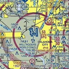
| Sectional chart |
|---|
|
 Download PDF
of official airport diagram from the FAA
| Airport distance calculator |
|---|
|
|
| Sunrise and sunset |
|---|
|
Times for 19-Apr-2024
| | Local
(UTC-5) | | Zulu
(UTC) |
|---|
| Morning civil twilight | | 06:26 | | 11:26 |
| Sunrise | | 06:53 | | 11:53 |
| Sunset | | 20:06 | | 01:06 |
| Evening civil twilight | | 20:33 | | 01:33 |
|
| Current date and time |
|---|
| Zulu (UTC) | 19-Apr-2024 22:58:50 |
|---|
| Local (UTC-5) | 19-Apr-2024 17:58:50 |
|---|
|
| METAR |
|---|
| KOKC | 192252Z 04011KT 10SM SCT085 BKN200 OVC250 17/00 A3010 RMK AO2 SLP189 T01720000
|
KPWA
9nm N | 192253Z 05012G15KT 10SM CLR 18/02 A3010 RMK AO2 SLP191 T01780022
|
KTIK
12nm E | 192155Z AUTO 05012KT 10SM CLR 18/M00 A3006 RMK AO2 SLP184 T01831005
|
KRCE
12nm NW | 192255Z AUTO 02011KT 10SM CLR 16/01 A3011 RMK AO2 TSNO
|
KOUN
13nm SE | 192145Z 01007G15KT 10SM CLR 18/02 A3008
|
KHSD
14nm N | 192235Z AUTO 03007G16KT 10SM 17/00 A3012 RMK A01
|
|
| TAF |
|---|
| KOKC | 192118Z 1921/2018 02010KT P6SM BKN250 FM200100 03008KT P6SM BKN100 OVC250 FM200800 04010KT P6SM BKN050 OVC100 TEMPO 2012/2016 -TSRA OVC030CB
|
KTIK
12nm E | 191700Z 1917/2023 05012KT 9999 SCT250 QNH3009INS BECMG 1920/1921 05009KT 9999 SCT250 QNH3009INS BECMG 2014/2015 05009KT 9000 -RA FEW015 OVC030 QNH3026INS BECMG 2018/2019 06012KT 9999 NSW FEW015 SCT030 BKN100 QNH3023INS TX17/1920Z TN07/2014Z
|
KOUN
13nm SE | 192113Z 1921/2018 03015KT P6SM BKN250 FM200100 03008KT P6SM BKN100 OVC250 FM200800 04010KT P6SM BKN050 OVC100 TEMPO 2011/2015 -TSRA OVC030CB AMD NOT SKED
|
|
| NOTAMs |
|---|
NOTAMs are issued by the DoD/FAA and will open in a separate window not controlled by AirNav.
|
|


