FAA INFORMATION EFFECTIVE 11 JUNE 2026
Location
| FAA Identifier: | M54 |
| Lat/Long: | 36-11-25.4804N 086-18-56.4855W
36-11.424673N 086-18.941425W
36.1904112,-86.3156904
(estimated) |
| Elevation: | 588.4 ft. / 179.3 m (surveyed) |
| Variation: | 02W (1995) |
| From city: | 2 miles SW of LEBANON, TN |
| Time zone: | UTC -5 (UTC -6 during Standard Time) |
| Zip code: | 37090 |
Airport Operations
| Airport use: | Open to the public |
| Activation date: | 10/1939 |
| Control tower: | no |
| ARTCC: | MEMPHIS CENTER |
| FSS: | NASHVILLE FLIGHT SERVICE STATION |
| NOTAMs facility: | BNA (NOTAM-D service available) |
| Attendance: | OCT - FEB 0700-1700, MAR - SEP 0700-1900
AFT HR - AMGR.
CLSD EASTER, THANKSGIVING, CHRISTMAS & NEW YEARS DAY. |
| Wind indicator: | lighted |
| Segmented circle: | yes |
| Lights: | SS-SR |
| Beacon: | white-green (lighted land airport)
Operates sunset to sunrise. |
Airport Communications
| CTAF/UNICOM: | 122.725 |
| WX AWOS-3: | 118.325 (615-444-5778) |
| NASHVILLE APPROACH: | 118.4 |
| NASHVILLE DEPARTURE: | 118.4 |
| WX AWOS-3 at XNX (12 nm N): | 132.725 (615-230-8005) |
| WX AWOS-3PT at MQY (15 nm SW): | 119.125 (615-223-7716) |
| WX ASOS at BNA (18 nm W): | PHONE 629-236-5115 |
| WX AWOS-3 at MBT (19 nm S): | 133.975 (615-849-2622) |
Nearby radio navigation aids
| VOR radial/distance | | VOR name | | Freq | | Var |
|---|
| BNAr082/18.2 | | NASHVILLE VORTAC | | 114.10 | | 02W |
| SYIr010/38.2 | | SHELBYVILLE VOR/DME | | 113.55 | | 01W |
| NDB name | | Hdg/Dist | | Freq | | Var | | ID |
|---|
| HUCHN | | 292/37.4 | | 233 | | 03W | | HEM | .... . -- |
Airport Services
| Fuel available: | 100LL JET-A |
| Parking: | hangars and tiedowns |
| Airframe service: | MAJOR |
| Powerplant service: | MAJOR |
| Bottled oxygen: | LOW
SERVICE UP TO 1800 PSI |
Runway Information
Runway 1/19
| Dimensions: | 5000 x 100 ft. / 1524 x 30 m |
| Surface: | asphalt, in good condition |
| Weight bearing capacity: | | PCN 19 /F/C/X/T | | Single wheel: | 51.0 | | Double wheel: | 71.0 |
|
| Runway edge lights: | medium intensity |
| RUNWAY 1 | | RUNWAY 19 |
| Latitude: | 36-11.019090N | | 36-11.837583N |
| Longitude: | 086-19.044848W | | 086-18.928898W |
| Elevation: | 588.0 ft. | | 549.7 ft. |
| Traffic pattern: | left | | left |
| Runway heading: | 009 magnetic, 007 true | | 189 magnetic, 187 true |
| Displaced threshold: | 400 ft. | | 500 ft. |
| Declared distances: | TORA:5000 TODA:5000 ASDA:4680 LDA:4527 | | TORA:5000 TODA:5000 ASDA:4847 LDA:4527 |
| Markings: | nonprecision, in good condition | | nonprecision, in good condition |
| Visual slope indicator: | 2-light PAPI on left (3.00 degrees glide path)
PAPI OTS INDEF. | | 2-light PAPI on left (3.00 degrees glide path) |
| Runway end identifier lights: | yes | | yes |
| Touchdown point: | yes, no lights | | yes, no lights |
| Obstructions: | 58 ft. trees, 1268 ft. from runway, 225 ft. right of centerline, 18:1 slope to clear | | none |
Runway 4/22
| Dimensions: | 1801 x 150 ft. / 549 x 46 m |
| Surface: | turf, in good condition |
| Runway edge markings: | THR & DTHR MKD 3 FT WHITE CONES. |
| RUNWAY 4 | | RUNWAY 22 |
| Latitude: | 36-11.312000N | | 36-11.517000N |
| Longitude: | 086-18.947667W | | 086-18.682833W |
| Elevation: | 568.0 ft. | | 565.0 ft. |
| Traffic pattern: | left | | left |
| Runway heading: | 048 magnetic, 046 true | | 228 magnetic, 226 true |
| Markings: | basic, in good condition | | basic, in good condition |
| Obstructions: | 113 ft. sign, 2500 ft. from runway, 297 ft. right of centerline, 22:1 slope to clear | | 54 ft. trees, 422 ft. from runway, 184 ft. right of centerline, 7:1 slope to clear |
Airport Ownership and Management from official FAA records
| Ownership: | Publicly-owned |
| Owner: | CITY OF LEBANON
200 CASTLE HEIGHTS AVE NORTH
LEBANON, TN 37087
Phone 615-443-2839 |
| Manager: | HEATHER BAY
200 AVIATION WAY, SUITE 116
LEBANON, TN 37090
Phone 615-604-7436 |
Additional Remarks
| A30A-19 | CALM WIND RWY. |
| - | WILDLIFE ON & INVOF ARPT. |
| - | FOR CD CTC NASHVILLE APCH AT 615-695-4522. |
| - | FLT TRNG WI ARPT AREA. |
Instrument Procedures
NOTE: All procedures below are presented as PDF files. If you need a reader for these files, you should download the free Adobe Reader.NOT FOR NAVIGATION. Please procure official charts for flight.
FAA instrument procedures published for use from 11 June 2026 at 0901Z to 09 July 2026 at 0900z.
IAPs - Instrument Approach Procedures |
|---|
| RNAV (GPS) RWY 01 | |
download (280KB) |
| RNAV (GPS) RWY 19 | |
download (339KB) |
| NOTE: Special Take-Off Minimums/Departure Procedures apply | |
download (399KB) |
Other nearby airports with instrument procedures:
KXNX - Music City Executive Airport (12 nm N)
KMQY - Smyrna Airport (15 nm SW)
KBNA - Nashville International Airport (18 nm W)
KMBT - Murfreesboro Municipal Airport (19 nm S)
3M7 - Lafayette Municipal Airport (23 nm NE)
|
|

Road maps at:
MapQuest
Bing
Google
| Aerial photo |
|---|
WARNING: Photo may not be current or correct
 Photo by Thomas Cheney
Photo taken 16-Jun-2013
looking southwest.
Photo by Thomas Cheney
Photo taken 16-Jun-2013
looking southwest.
Do you have a better or more recent aerial photo of Lebanon Municipal Airport that you would like to share? If so, please send us your photo.
|
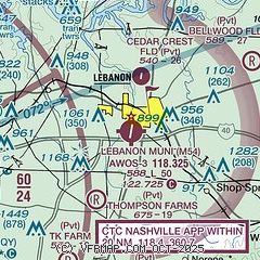
| Sectional chart |
|---|
|
| Airport distance calculator |
|---|
|
|
| Sunrise and sunset |
|---|
|
Times for 08-Jul-2026
| | Local
(UTC-5) | | Zulu
(UTC) |
|---|
| Morning civil twilight | | 05:06 | | 10:06 |
| Sunrise | | 05:36 | | 10:36 |
| Sunset | | 20:04 | | 01:04 |
| Evening civil twilight | | 20:34 | | 01:34 |
|
| Current date and time |
|---|
| Zulu (UTC) | 08-Jul-2026 12:54:44 |
|---|
| Local (UTC-5) | 08-Jul-2026 07:54:44 |
|---|
|
| METAR |
|---|
| KM54 | 081235Z AUTO 21006KT 10SM OVC012 23/23 A3006 RMK A01
|
KXNX
12nm N | 081235Z AUTO 00000KT 3SM BR OVC004 23/23 A3011 RMK A01
|
KMQY
14nm SW | 081232Z 14003KT 10SM SCT019 SCT036 23/23 A3010 RMK AO2
|
KBNA
18nm W | 081153Z 00000KT 10SM FEW017 SCT023 BKN250 23/21 A3008 RMK AO2 SLP179 70006 T02280206 10228 20211 53013 $
|
KMBT
19nm S | 081235Z AUTO 23003KT 10SM SCT039 24/23 A3008 RMK A01
|
|
| TAF |
|---|
KMQY
14nm SW | 081120Z 0812/0912 00000KT P6SM SCT020 FM081500 25006KT P6SM BKN050 PROB30 0817/0823 5SM -TSRA OVC035CB FM090300 20002KT P6SM SCT150
|
KBNA
18nm W | 081120Z 0812/0918 00000KT P6SM SCT015 SCT150 FM081500 28005KT P6SM BKN040 PROB30 0817/0823 5SM -TSRA OVC035CB FM090300 18002KT P6SM SCT150
|
|
| NOTAMs |
|---|
NOTAMs are issued by the DoD/FAA and will open in a separate window not controlled by AirNav.
|
|


