FAA INFORMATION EFFECTIVE 19 MARCH 2026
Location
| FAA Identifier: | M66 |
| Lat/Long: | 38-20-29.6550N 097-12-49.9400W
38-20.494250N 097-12.832333W
38.3415708,-97.2138722
(estimated) |
| Elevation: | 1434 ft. / 437.1 m (surveyed) |
| Variation: | 07E (1985) |
| Time zone: | UTC -5 (UTC -6 during Standard Time) |
| Zip code: | 67063 |
Airport Operations
| Airport use: | Open to the public |
| Activation date: | 01/1952 |
| Control tower: | no |
| ARTCC: | KANSAS CITY CENTER |
| FSS: | WICHITA FLIGHT SERVICE STATION |
| NOTAMs facility: | ICT (NOTAM-D service available) |
| Attendance: | UNATNDD |
| Wind indicator: | yes |
| Segmented circle: | no |
| Lights: | ACTVT PAPI RWY 17 & 35, LIRL RWY 17/35; - CTAF. |
| Beacon: | white-green (lighted land airport)
Operates sunset to sunrise. |
Airport Communications
| CTAF: | 122.9 |
| WX AWOS-3PT at EWK (17 nm S): | 123.875 (316-283-8789) |
Nearby radio navigation aids
| VOR radial/distance | | VOR name | | Freq | | Var |
|---|
| HUTr055/39.8 | | HUTCHINSON VOR/DME | | 116.80 | | 04E |
| ICTr019/39.8 | | WICHITA VORTAC | | 113.80 | | 07E |
| SLNr144/39.9 | | SALINA VORTAC | | 117.10 | | 07E |
| NDB name | | Hdg/Dist | | Freq | | Var | | ID |
|---|
| HARVS | | 008/12.2 | | 395 | | 06E | | CA | -.-. .- |
| HERINGTON | | 216/28.3 | | 407 | | 06E | | HRU | .... .-. ..- |
Airport Services
| Fuel available: | 100LL
100LL:100LL FUEL 24 HR SELF-SERVE. |
| Parking: | hangars and tiedowns |
| Airframe service: | NONE |
| Powerplant service: | NONE |
| Bottled oxygen: | NONE |
| Bulk oxygen: | NONE |
Runway Information
Runway 17/35
| Dimensions: | 3229 x 44 ft. / 984 x 13 m |
| Surface: | asphalt, in fair condition |
| Runway edge lights: | low intensity |
| RUNWAY 17 | | RUNWAY 35 |
| Latitude: | 38-20.760000N | | 38-20.228500N |
| Longitude: | 097-12.818833W | | 097-12.845833W |
| Elevation: | 1434.0 ft. | | 1416.0 ft. |
| Traffic pattern: | left | | left |
| Markings: | numbers only, in fair condition | | numbers only, in fair condition |
| Visual slope indicator: | 4-light PAPI on left (3.75 degrees glide path) | | 4-light PAPI on left (3.75 degrees glide path) |
| Touchdown point: | yes, no lights | | yes, no lights |
| Obstructions: | 15 ft. road, 704 ft. from runway, 33:1 slope to clear | | 38 ft. trees, 1164 ft. from runway, 72 ft. left of centerline, 25:1 slope to clear
RWY 35, 28 FT TREES, 0 FT DSTC, 120 FT L/R. |
Helipad H1
| Dimensions: | 40 x 40 ft. / 12 x 12 m |
| Surface: | concrete, in good condition |
| Latitude: | 38-20.772333N | | |
| Longitude: | 097-12.842000W | | |
| Elevation: | 1435.0 ft. | | |
| Traffic pattern: | left | | left |
| Markings: | basic, in good condition | | |
| Obstructions: | bldg, lighted | | |
Airport Ownership and Management from official FAA records
| Ownership: | Publicly-owned |
| Owner: | CITY OF HILLSBORO
118 EAST GRAND
HILLSBORO, KS 67063
Phone 620-947-3162 |
| Manager: | MATT STILES
118 EAST GRAND
HILLSBORO, KS 67063
Phone 620-947-3162
CITY ADMIN/AMGR. |
Additional Remarks
| - | ULTRALIGHT ACTIVITY INVOF ARPT. |
| - | PHONE AVBL 24 HRS IN PILOTS LOUNGE; 620-416-6102 |
| - | FOR CD CTC WICHITA APCH AT 316-350-1520. |
Instrument Procedures
There are no published instrument procedures at M66.
Some nearby airports with instrument procedures:
47K - Moundridge Municipal Airport (16 nm SW)
KEWK - Newton City/County Airport (17 nm S)
KMPR - Mc Pherson Airport (22 nm W)
KHRU - Herington Regional Airport (28 nm NE)
K78 - Abilene Municipal Airport (34 nm N)
|
|

Road maps at:
MapQuest
Bing
Google
| Aerial photo |
|---|
WARNING: Photo may not be current or correct

Do you have a better or more recent aerial photo of Alfred Schroeder Field Airport that you would like to share? If so, please send us your photo.
|
| Sectional chart |
|---|
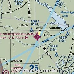
|
| Airport distance calculator |
|---|
|
|
| Sunrise and sunset |
|---|
|
Times for 09-Apr-2026
| | Local
(UTC-5) | | Zulu
(UTC) |
|---|
| Morning civil twilight | | 06:36 | | 11:36 |
| Sunrise | | 07:03 | | 12:03 |
| Sunset | | 19:58 | | 00:58 |
| Evening civil twilight | | 20:25 | | 01:25 |
|
| Current date and time |
|---|
| Zulu (UTC) | 09-Apr-2026 14:41:31 |
|---|
| Local (UTC-5) | 09-Apr-2026 09:41:31 |
|---|
|
| METAR |
|---|
KEWK
19nm S | 091356Z AUTO 18012KT 10SM CLR 17/09 A3008 RMK AO2 SLP177 T01720089 $
|
KMPR
22nm W | 091355Z AUTO 17019G23KT 10SM CLR 17/09 A3005 RMK AO2 T01710088
|
KSLN
33nm NW | 091423Z 18005KT 10SM VCTS BKN090 OVC110 17/09 A3006 RMK AO2 LTG DSNT W AND NW TS VC W MOV NE T01720094
|
KHUT
35nm SW | 091352Z 15012KT 10SM CLR 16/09 A3005 RMK AO2 SLP161 T01610089
|
KAAO
35nm S | 091354Z AUTO 17011KT 10SM CLR 17/09 A3008 RMK AO2 SLP179 T01670089
|
|
| TAF |
|---|
KSLN
33nm NW | 091423Z 0914/1012 18008KT P6SM VCSH SCT070 BKN100 TEMPO 0914/0916 6SM -TSRA BKN070CB FM091700 18018G27KT P6SM BKN100 PROB30 0923/1005 4SM TSRA BKN050CB FM100600 09009KT 6SM -SHRA BR BKN080 FM100900 10008KT 5SM -SHRA BR BKN030
|
KHUT
35nm SW | 091120Z 0912/1012 16010KT P6SM VCSH FEW080 SCT100 FM091700 18020G30KT P6SM SCT100 FM100500 18013G21KT P6SM VCTS SCT100CB FM100800 19010KT 6SM -SHRA BR SCT050 BKN070 WS020/21040KT FM101100 15008KT P6SM BKN040
|
|
| NOTAMs |
|---|
NOTAMs are issued by the DoD/FAA and will open in a separate window not controlled by AirNav.
|
|

