FAA INFORMATION EFFECTIVE 18 APRIL 2024
Location
| FAA Identifier: | PJC |
| Lat/Long: | 40-48-07.1000N 080-09-39.1000W
40-48.118333N 080-09.651667W
40.8019722,-80.1608611
(estimated) |
| Elevation: | 897.8 ft. / 273.6 m (surveyed) |
| Variation: | 09W (2000) |
| From city: | 1 mile W of ZELIENOPLE, PA |
| Time zone: | UTC -4 (UTC -5 during Standard Time) |
| Zip code: | 16123 |
Airport Operations
| Airport use: | Open to the public |
| Activation date: | 03/1958 |
| Control tower: | no |
| ARTCC: | CLEVELAND CENTER |
| FSS: | ALTOONA FLIGHT SERVICE STATION |
| NOTAMs facility: | AOO (NOTAM-D service available) |
| Attendance: | MON-FRI 0600-2200, ALL SAT-SUN ON CALL
FOR ATTENDANT SAT-SUN CALL 724-452-4719. |
| Wind indicator: | lighted |
| Segmented circle: | no |
| Lights: | ACTVT REIL RWY 17 & 35; MIRL RWY 17/35 AFT 2200 - CTAF. PAPI CONS & MIRL OPER DUSK-2200. |
| Beacon: | white-green (lighted land airport)
Operates sunset to sunrise. |
Airport Communications
| CTAF: | 122.9 |
| WX AWOS-3PT: | 118.45 (724-452-5304) |
| PITTSBURGH APPROACH: | 124.75 |
| PITTSBURGH DEPARTURE: | 124.75 |
| WX AWOS-3PT at BTP (10 nm E): | 121.450 (724-586-6434) |
| WX AWOS-3PT at BVI (11 nm W): | 118.35 (724-843-1024) |
| WX AWOS-3PT at UCP (18 nm NW): | 124.175 ((724) 652-4184) |
| WX ASOS at PIT (19 nm S): | PHONE 412-472-0145 |
Nearby radio navigation aids
| VOR radial/distance | | VOR name | | Freq | | Var |
|---|
| EWCr129/2.7 | | ELLWOOD CITY VOR/DME | | 115.80 | | 08W |
| AGCr359/31.9 | | ALLEGHENY VOR/DME | | 110.00 | | 09W |
| HLGr037/37.5 | | WHEELING VOR/DME | | 114.25 | | 07W |
| YNGr149/39.3 | | YOUNGSTOWN VORTAC | | 109.00 | | 05W |
| NDB name | | Hdg/Dist | | Freq | | Var | | ID |
|---|
| CASTLE | | 148/17.6 | | 272 | | 09W | | UCP | ..- -.-. .--. |
Airport Services
| Fuel available: | 100LL JET-A JET-A+ |
| Parking: | hangars and tiedowns |
| Airframe service: | MAJOR |
| Powerplant service: | MAJOR |
| Bottled oxygen: | HIGH |
| Bulk oxygen: | LOW |
Runway Information
Runway 17/35
| Dimensions: | 4933 x 75 ft. / 1504 x 23 m |
| Surface: | asphalt, in good condition |
| Runway edge lights: | medium intensity |
| RUNWAY 17 | | RUNWAY 35 |
| Latitude: | 40-48.511208N | | 40-47.725148N |
| Longitude: | 080-09.786162W | | 080-09.516012W |
| Elevation: | 889.9 ft. | | 896.2 ft. |
| Traffic pattern: | left | | left |
| Runway heading: | 174 magnetic, 165 true | | 354 magnetic, 345 true |
| Displaced threshold: | 551 ft. | | 282 ft. |
| Declared distances: | TORA:4932 TODA:4932 ASDA:4932 LDA:4381 | | TORA:4932 TODA:4932 ASDA:4932 LDA:4650 |
| Markings: | nonprecision, in fair condition | | nonprecision, in good condition |
| Visual slope indicator: | | | 2-light PAPI on left (3.48 degrees glide path)
PAPI UNUSBL BYD 5 DEG L OF CNTRLN. |
| Runway end identifier lights: | yes | | yes |
| Touchdown point: | yes, no lights | | yes, no lights |
| Obstructions: | 109 ft. trees, 1988 ft. from runway, 249 ft. left of centerline, 16:1 slope to clear
RWY 17 108 FT TREES, 1988 FT FM THLD 249 FT RIGHT. 16:1 TO THLD. | | 56 ft. pole, lighted, 480 ft. from runway, 267 ft. left of centerline, 5:1 slope to clear
NON-STD LGTG; UTILITY POLE LIT FROM THE BOTTOM. |
Airport Ownership and Management from official FAA records
| Ownership: | Publicly-owned |
| Owner: | ARPT AUTH BORO ZELIENOPLE
100 TASA DRIVE
ZELIENOPLE, PA 16063
Phone 724-452-1290 |
| Manager: | DAVE HOLMAN
220 TASA DRIVE
ZELIENOPLE, PA 16063
Phone 724-452-4719 |
Airport Operational Statistics
| Aircraft based on the field: | | 53 | | Single engine airplanes: | | 41 | | Multi engine airplanes: | | 3 | | Jet airplanes: | | 3 | | Helicopters: | | 6 |
| |  | |
| Aircraft operations: avg 115/day * | | 79% | local general aviation | | 15% | transient general aviation | | 5% | air taxi | | <1% | military | | * for 12-month period ending 13 October 2020 | |
Additional Remarks
| - | DEER & GEESE ON & INVOF RWY. |
| - | PARALLEL TXY MKD WITH REFLECTORS. |
| - | FOR CD CTC PITTSBURGH APCH AT 412-472-5591. |
| - | RWY 35 68 FT LGT POLE 720 FT FM THLD, 291 FT RT. 56 FT LGT POLE 480 FT FM THLD, 267 FT LT. POLES LGT FM THE BOTTOM. |
Instrument Procedures
NOTE: All procedures below are presented as PDF files. If you need a reader for these files, you should download the free Adobe Reader.NOT FOR NAVIGATION. Please procure official charts for flight.
FAA instrument procedures published for use from 18 April 2024 at 0901Z to 16 May 2024 at 0900Z.
IAPs - Instrument Approach Procedures |
|---|
| RNAV (GPS) RWY 17 | |
download (184KB) |
| RNAV (GPS) RWY 35 | |
download (197KB) |
| NOTE: Special Take-Off Minimums/Departure Procedures apply | |
download (149KB) |
Other nearby airports with instrument procedures:
KBTP - Pittsburgh/Butler Regional Airport (10 nm E)
KBVI - Beaver County Airport (11 nm W)
KUCP - New Castle Municipal Airport (18 nm NW)
KPIT - Pittsburgh International Airport (19 nm S)
29D - Grove City Airport (21 nm N)
|
|

Road maps at:
MapQuest
Bing
Google
| Aerial photo |
|---|
WARNING: Photo may not be current or correct
 Photo taken 22-Jun-2015
looking north.
Photo taken 22-Jun-2015
looking north.
Do you have a better or more recent aerial photo of Zelienople Municipal Airport that you would like to share? If so, please send us your photo.
|
| Sectional chart |
|---|
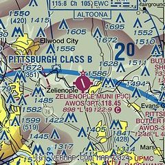
|
| Airport distance calculator |
|---|
|
|
| Sunrise and sunset |
|---|
|
Times for 20-Apr-2024
| | Local
(UTC-4) | | Zulu
(UTC) |
|---|
| Morning civil twilight | | 06:05 | | 10:05 |
| Sunrise | | 06:34 | | 10:34 |
| Sunset | | 20:05 | | 00:05 |
| Evening civil twilight | | 20:34 | | 00:34 |
|
| Current date and time |
|---|
| Zulu (UTC) | 20-Apr-2024 04:57:10 |
|---|
| Local (UTC-4) | 20-Apr-2024 00:57:10 |
|---|
|
| METAR |
|---|
| KPJC | 200455Z AUTO 28006KT 10SM OVC110 11/02 A3004 RMK AO2
|
KBTP
10nm E | 200356Z AUTO 28006KT 10SM CLR 11/04 A3004 RMK AO2 SLP177 T01110044 TSNO $
|
KBVI
11nm W | 200455Z AUTO 31005KT 10SM OVC110 12/00 A3005 RMK AO2 T01190000
|
KUCP
18nm NW | 200356Z AUTO 27005KT 10SM BKN120 12/01 A3005 RMK AO2 SLP191 T01170011
|
KPIT
19nm S | 200451Z 29009KT 10SM BKN110 OVC180 12/02 A3004 RMK AO2 SLP178 T01220022 402110122 $
|
|
| TAF |
|---|
KBVI
11nm W | 192206Z 1922/2018 30010G16KT P6SM BKN035 FM192300 31005KT P6SM SCT025 FM201400 26010G19KT P6SM SCT035
|
KPIT
19nm S | 200258Z 2003/2106 30008KT P6SM BKN150 FM201400 28015G25KT P6SM SCT050 FM210100 32005KT P6SM SCT050
|
|
| NOTAMs |
|---|
NOTAMs are issued by the DoD/FAA and will open in a separate window not controlled by AirNav.
|
|

