FAA INFORMATION EFFECTIVE 11 JUNE 2026
Location
| FAA Identifier: | 07F |
| Lat/Long: | 32-31-43.8000N 094-58-18.3000W
32-31.730000N 094-58.305000W
32.5288333,-94.9717500
(estimated) |
| Elevation: | 296.5 ft. / 90.4 m (surveyed) |
| Variation: | 03E (2010) |
| From city: | 2 miles SW of GLADEWATER, TX |
| Time zone: | UTC -5 (UTC -6 during Standard Time) |
| Zip code: | 75647 |
Airport Operations
| Airport use: | Open to the public |
| Activation date: | 03/1951 |
| Control tower: | no |
| ARTCC: | FORT WORTH CENTER |
| FSS: | FORT WORTH FLIGHT SERVICE STATION |
| NOTAMs facility: | FTW (NOTAM-D service available) |
| Attendance: | 0800-1700
FOR SVC AFT HRS CALL 903-235-0784. |
| Wind indicator: | lighted |
| Segmented circle: | no |
| Lights: | SS-SR |
| Beacon: | white-green (lighted land airport)
Operates sunset to sunrise. |
Airport Communications
| CTAF: | 122.9 |
| LONGVIEW APPROACH: | 124.275 |
| LONGVIEW DEPARTURE: | 124.275 |
| WX AWOS-3PT at JXI (10 nm N): | 120.250 (903-734-7313) |
| WX ASOS at GGG (16 nm SE): | PHONE 903-643-4029 |
- APCH/DEP CTL SVC PRVDD BY FORT WORTH ARTCC (ZFW) ON FREQS 126.325/346.25 (SHREVEPORT RCAG) WHEN LONGVIEW APCH CTL (GGG) CLSD.
Nearby radio navigation aids
| VOR radial/distance | | VOR name | | Freq | | Var |
|---|
| GGGr294/12.9 | | GREGG COUNTY VORTAC | | 112.90 | | 07E |
| TYRr059/24.2 | | TYLER VOR/DME | | 114.20 | | 06E |
| FZTr040/39.3 | | FRANKSTON VOR/DME | | 111.40 | | 06E |
| NDB name | | Hdg/Dist | | Freq | | Var | | ID |
|---|
| AMBASSADOR | | 108/7.9 | | 404 | | 07E | | ABG | .- -... --. |
Airport Services
| Fuel available: | 100LL |
| Parking: | tiedowns |
| Airframe service: | NONE |
| Powerplant service: | NONE |
| Bottled oxygen: | NONE |
| Bulk oxygen: | NONE |
Runway Information
Runway 14/32
| Dimensions: | 3299 x 75 ft. / 1006 x 23 m |
| Surface: | asphalt, in poor condition |
| Weight bearing capacity: | |
| Runway edge lights: | medium intensity |
| RUNWAY 14 | | RUNWAY 32 |
| Latitude: | 32-31.992575N | | 32-31.559890N |
| Longitude: | 094-58.519453W | | 094-58.130095W |
| Elevation: | 285.0 ft. | | 295.6 ft. |
| Traffic pattern: | left | | left |
| Runway heading: | 140 magnetic, 143 true | | 320 magnetic, 323 true |
| Markings: | nonprecision, in good condition | | nonprecision, in good condition |
| Visual slope indicator: | 2-light PAPI on left (3.00 degrees glide path) | | |
| Touchdown point: | yes, no lights | | yes, no lights |
| Obstructions: | 25 ft. trees, 201 ft. from runway, 130 ft. right of centerline
15 FT TREES, 0-199 FT DSTC, 84 FT R. | | 85 ft. trees, 1050 ft. from runway, 415 ft. left and right of centerline, 10:1 slope to clear
12 FT TREES, 50 FT DSTC, 130 FT L. |
Runway 17/35
| Dimensions: | 2300 x 50 ft. / 701 x 15 m |
| Surface: | asphalt, in good condition
NMRS CRACKS, LOOSE STONES. |
| Weight bearing capacity: | |
| RUNWAY 17 | | RUNWAY 35 |
| Latitude: | 32-31.854435N | | 32-31.475298N |
| Longitude: | 094-58.280523W | | 094-58.271338W |
| Elevation: | 291.9 ft. | | 294.6 ft. |
| Traffic pattern: | left | | left |
| Runway heading: | 176 magnetic, 179 true | | 356 magnetic, 359 true |
| Markings: | basic, in good condition | | basic, in good condition |
| Touchdown point: | yes, no lights | | yes, no lights |
| Obstructions: | 45 ft. trees, 268 ft. from runway, 125 ft. left of centerline, 1:1 slope to clear | | 40 ft. trees, 375 ft. from runway, 55 ft. left of centerline, 4:1 slope to clear |
Airport Ownership and Management from official FAA records
| Ownership: | Publicly-owned |
| Owner: | CITY OF GLADEWATER
519 E BROADWAY AVE, PO BOX 1725
GLADEWATER, TX 75647
Phone 903-845-2196 |
| Manager: | CHARLIE SMITH
519 E BROADWAY AVE, PO BOX 1725
GLADEWATER, TX 75647
Phone 903-845-2586 |
Additional Remarks
| - | FOR CD CTC FORT WORTH ARTCC AT 817-858-7584. |
| - | ARPT PHYS ADDR 1300 US-271, GLADEWATER, TX |
Instrument Procedures
NOTE: All procedures below are presented as PDF files. If you need a reader for these files, you should download the free Adobe Reader.NOT FOR NAVIGATION. Please procure official charts for flight.
FAA instrument procedures published for use from 11 June 2026 at 0901Z to 09 July 2026 at 0900z.
IAPs - Instrument Approach Procedures |
|---|
| RNAV (GPS) RWY 14 | |
download (216KB) |
| RNAV (GPS) RWY 32 | |
download (216KB) |
| NOTE: Special Take-Off Minimums/Departure Procedures apply | |
download (305KB) |
Other nearby airports with instrument procedures:
KJXI - Fox Stephens Field/Gilmer Municipal Airport (10 nm N)
KGGG - East Texas Regional Airport (16 nm SE)
KRFI - Rusk County Airport (24 nm S)
KTYR - Tyler Pounds Regional Airport (24 nm SW)
F51 - Winnsboro Municipal Airport (29 nm NW)
|
|

Road maps at:
MapQuest
Bing
Google
| Aerial photo |
|---|
WARNING: Photo may not be current or correct
 Photo by Byron Thibodeaux
Photo taken 10-Jun-2013
looking northwest.
Photo by Byron Thibodeaux
Photo taken 10-Jun-2013
looking northwest.
Do you have a better or more recent aerial photo of Gladewater Municipal Airport that you would like to share? If so, please send us your photo.
|
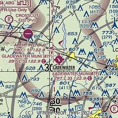
| Sectional chart |
|---|
|
| Airport distance calculator |
|---|
|
|
| Sunrise and sunset |
|---|
|
Times for 17-Jun-2026
| | Local
(UTC-5) | | Zulu
(UTC) |
|---|
| Morning civil twilight | | 05:45 | | 10:45 |
| Sunrise | | 06:13 | | 11:13 |
| Sunset | | 20:28 | | 01:28 |
| Evening civil twilight | | 20:57 | | 01:57 |
|
| Current date and time |
|---|
| Zulu (UTC) | 17-Jun-2026 08:54:43 |
|---|
| Local (UTC-5) | 17-Jun-2026 03:54:43 |
|---|
|
| METAR |
|---|
KJXI
10nm N | 170815Z AUTO 00000KT 10SM CLR 23/22 A2976 RMK AO2 T02300218
|
KGGG
16nm SE | 170827Z AUTO 19004KT 10SM BKN003 OVC007 24/23 A2974 RMK AO2 T02390233
|
|
| TAF |
|---|
KGGG
16nm SE | 170520Z 1706/1806 14004KT P6SM SKC FM171200 17006KT P6SM OVC015 FM171500 17010G17KT P6SM BKN025 FM171700 18013G20KT P6SM SCT035 BKN250 FM180000 15010KT P6SM SCT030 FM180200 14008KT P6SM OVC025
|
|
| NOTAMs |
|---|
NOTAMs are issued by the DoD/FAA and will open in a separate window not controlled by AirNav.
|
|

