FAA INFORMATION EFFECTIVE 18 APRIL 2024
Location
| FAA Identifier: | 32PA |
| Lat/Long: | 40-12-14.5740N 075-25-48.9470W
40-12.242900N 075-25.815783W
40.2040483,-75.4302631
(estimated) |
| Elevation: | 277 ft. / 84 m (estimated) |
| Variation: | 12W (2005) |
| From city: | 2 miles NE of COLLEGEVILLE, PA |
| Time zone: | UTC -4 (UTC -5 during Standard Time) |
| Zip code: | 19426 |
Airport Operations
| Airport use: | Private use. Permission required prior to landing |
| Control tower: | no |
| ARTCC: | NEW YORK CENTER |
| FSS: | WILLIAMSPORT FLIGHT SERVICE STATION |
| NOTAMs facility: | IPT (NOTAM-D service available) |
| Attendance: | UNATNDD |
| Wind indicator: | no |
| Segmented circle: | no |
Airport Communications
| CTAF/UNICOM: | 122.8 |
| PHILADELPHIA APPROACH: | 126.85 |
| PHILADELPHIA DEPARTURE: | 126.85 |
| CLEARANCE DELIVERY: | 118.55 |
| WX ASOS at PTW (6 nm W): | 119.425 (610-495-0823) |
| WX AWOS-3 at LOM (9 nm SE): | 118.925 (215-646-1068) |
| WX AWOS-3 at CKZ (13 nm NE): | 126.325 (215-257-7291) |
| WX AWOS-3 at UKT (14 nm N): | 119.475 (215-538-7610) |
| WX AWOS-3T at OQN (15 nm SW): | 121.4 ((610) 692-6190) |
| WX ASOS at DYL (16 nm NE): | 118.875 (215-345-0392) |
- CLEARANCE DELIVERY PHILADELPHIA APCH TF 800-354-9884.
Nearby radio navigation aids
| VOR radial/distance | | VOR name | | Freq | | Var |
|---|
| PTWr109/6.1 | | POTTSTOWN VORTAC | | 116.50 | | 09W |
| MXEr042/20.4 | | MODENA VORTAC | | 113.20 | | 09W |
| ARDr273/24.1 | | YARDLEY VOR/DME | | 108.20 | | 10W |
| ETXr162/25.4 | | EAST TEXAS VOR/DME | | 110.20 | | 09W |
| FJCr188/31.4 | | ALLENTOWN VORTAC | | 117.50 | | 10W |
| DQOr024/32.6 | | DUPONT VORTAC | | 114.00 | | 10W |
| OODr000/34.6 | | WOODSTOWN VORTAC | | 112.80 | | 10W |
| SBJr244/38.8 | | SOLBERG VOR/DME | | 112.90 | | 10W |
| LRPr092/39.8 | | LANCASTER VOR/DME | | 117.30 | | 09W |
Airport Services
| Parking: | tiedowns |
| Bottled oxygen: | NONE |
| Bulk oxygen: | NONE |
Runway Information
Runway 9/27
| Dimensions: | 2880 x 40 ft. / 878 x 12 m |
| Surface: | asphalt, in poor condition
UNSEALED CRACKS AND JOINTS IN ASPH. |
| Weight bearing capacity: | |
| Runway edge markings: | MARKINGS, ARROWS SML AND MISALIGNED, DBL THR BAR AND SML NRS, FADED. |
| RUNWAY 9 | | RUNWAY 27 |
| Latitude: | 40-12.187135N | | 40-12.298545N |
| Longitude: | 075-26.115893W | | 075-25.514570W |
| Elevation: | 245.0 ft. | | 273.0 ft. |
| Traffic pattern: | left | | left |
| Runway heading: | 088 magnetic, 076 true | | 268 magnetic, 256 true |
| Displaced threshold: | 420 ft.
DTHR LGTS 150 FT DOWN RWY FM THR MARKING. | | 370 ft.
DTHR MKD WITH 2 PARL WHITE LINES; LGTD WITH 4 RED & GREEN LGTS EACH SIDE OF RWY. |
| Markings: | NSTD, in poor condition | | NSTD, in poor condition |
| Touchdown point: | yes, no lights | | yes, no lights |
| Obstructions: | 45 ft. trees, 203 ft. from runway, 50 ft. both sides of centerline
20 FT ROAD AT THR 37 FT LEFT TO 250 FT RIGHT. MULT TREES 50 FT IN OFZ. | | 58 ft. trees, 806 ft. from runway, 42 ft. left of centerline, 10:1 slope to clear
7 FT RD AT THR 135 FT RIGHT TO 192 FT LEFT. 48 FT TREES 99 FT FM RWY END. |
Airport Ownership and Management from official FAA records
| Ownership: | Privately-owned |
| Owner: | PV53, LLC
2620 EGYPT ROAD
EAGLEVILLE, PA 19403
Phone 610-999-3560 |
| Manager: | DAVID RITTENHOUSE
767 COLLEGEVILLE RD
COLLEGEVILLE, PA 19426
Phone (610) 999-3560 |
Airport Operational Statistics
| Aircraft based on the field: | | 3 | | Single engine airplanes: | | 3 |
| |  | |
| Aircraft operations: avg 22/month * | | 58% | local general aviation | | 38% | transient general aviation | | 4% | military | | * for 12-month period ending 20 September 2018 | |
Additional Remarks
| - | FOR CD CTC PHILADELPHIA APCH AT 800-354-9884. |
| - | ARPT CLSD FOR PUB USE. |
| - | DEER, FOX, GEESE ON AND INVOF RWY. |
Instrument Procedures
There are no published instrument procedures at 32PA.
Some nearby airports with instrument procedures:
KPTW - Heritage Field Airport (6 nm W)
KLOM - Wings Field Airport (9 nm SE)
N47 - Pottstown Municipal Airport (12 nm W)
KCKZ - Pennridge Airport (13 nm NE)
KUKT - Quakertown Airport (14 nm N)
KOQN - Brandywine Regional Airport (15 nm SW)
KDYL - Doylestown Airport (16 nm NE)
|
|

Road maps at:
MapQuest
Bing
Google
| Aerial photo |
|---|
WARNING: Photo may not be current or correct
 Photo taken 12-Dec-2012
Taken at 1400' looking west.
Photo taken 12-Dec-2012
Taken at 1400' looking west.
Do you have a better or more recent aerial photo of Perkiomen Valley Airport that you would like to share? If so, please send us your photo.
|
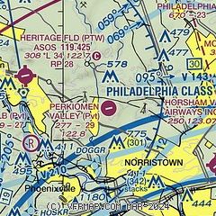
| Sectional chart |
|---|
|
| Airport distance calculator |
|---|
|
|
| Sunrise and sunset |
|---|
|
Times for 25-Apr-2024
| | Local
(UTC-4) | | Zulu
(UTC) |
|---|
| Morning civil twilight | | 05:40 | | 09:40 |
| Sunrise | | 06:09 | | 10:09 |
| Sunset | | 19:50 | | 23:50 |
| Evening civil twilight | | 20:19 | | 00:19 |
|
| Current date and time |
|---|
| Zulu (UTC) | 25-Apr-2024 20:28:18 |
|---|
| Local (UTC-4) | 25-Apr-2024 16:28:18 |
|---|
|
| METAR |
|---|
KPTW
6nm W | 251954Z AUTO 00000KT 10SM SCT060 13/00 A3028 RMK AO2 SLP252 T01330000
|
KLOM
9nm SE | 252015Z AUTO 03007KT 340V050 10SM CLR 15/00 A3027 RMK AO2 T01500002
|
KCKZ
13nm NE | 252015Z AUTO 00000KT 10SM FEW060 13/M01 A3027 RMK AO2
|
KUKT
14nm N | 252015Z AUTO 00000KT 10SM OVC060 14/M01 A3026 RMK AO2
|
KOQN
15nm SW | 252015Z AUTO 00000KT 10SM SCT060 14/00 A3027 RMK AO2
|
KDYL
16nm NE | 251954Z AUTO 05003KT 10SM CLR 15/M01 A3026 RMK AO2 SLP248 T01501006
|
|
| NOTAMs |
|---|
NOTAMs are issued by the DoD/FAA and will open in a separate window not controlled by AirNav.
|
|
