FAA INFORMATION EFFECTIVE 14 MAY 2026
Location
| FAA Identifier: | 60R |
| Lat/Long: | 30-22-01.7000N 096-06-46.6000W
30-22.028333N 096-06.776667W
30.3671389,-96.1129444
(estimated) |
| Elevation: | 229 ft. / 69.8 m (surveyed) |
| Variation: | 03E (2015) |
| From city: | 2 miles SW of NAVASOTA, TX |
| Time zone: | UTC -5 (UTC -6 during Standard Time) |
| Zip code: | 77868 |
Airport Operations
| Airport use: | Open to the public |
| Activation date: | 08/1963 |
| Control tower: | no |
| ARTCC: | HOUSTON CENTER |
| FSS: | MONTGOMERY COUNTY FLIGHT SERVICE STATION |
| NOTAMs facility: | CXO (NOTAM-D service available) |
| Attendance: | UNATNDD |
| Wind indicator: | lighted |
| Segmented circle: | yes |
| Lights: | ACTVT PAPI RWY 17 & 35; MIRL RWY 17/35 - 123.3. |
| Beacon: | white-green (lighted land airport)
Operates sunset to sunrise. |
Airport Communications
| CTAF: | 122.9 |
| WX AWOS-3PT: | 120.925 (936-825-0798) |
| HOUSTON APPROACH: | 134.3 [MIDLAND 0600-0000 SAN ANGELO 0600-2100] |
| HOUSTON DEPARTURE: | 134.3 [MIDLAND 0600-0000 SAN ANGELO 0600-2100] |
| WX AWOS-3 at 11R (16 nm SW): | 121.125 (979-836-2303) |
| WX ASOS at CLL (19 nm NW): | PHONE 979-846-1708 |
Nearby radio navigation aids
| VOR radial/distance | | VOR name | | Freq | | Var |
|---|
| TNVr321/5.5 | | NAVASOTA VOR/DME | | 115.90 | | 08E |
| CLLr124/21.4 | | COLLEGE STATION VORTAC | | 113.30 | | 08E |
| NDB name | | Hdg/Dist | | Freq | | Var | | ID |
|---|
| ROWDY | | 120/13.9 | | 260 | | 03E | | CL | -.-. .-.. |
Airport Services
| Fuel available: | 100LL JET-A |
| Parking: | tiedowns |
| Airframe service: | MAJOR |
| Powerplant service: | MAJOR |
| Bottled oxygen: | NONE |
| Bulk oxygen: | NONE |
Runway Information
Runway 17/35
| Dimensions: | 5003 x 75 ft. / 1525 x 23 m |
| Surface: | asphalt, in fair condition |
| Weight bearing capacity: | |
| Runway edge lights: | medium intensity |
| RUNWAY 17 | | RUNWAY 35 |
| Latitude: | 30-22.440387N | | 30-21.615837N |
| Longitude: | 096-06.798785W | | 096-06.756133W |
| Elevation: | 229.0 ft. | | 194.0 ft. |
| Traffic pattern: | left | | left |
| Runway heading: | 175 magnetic, 178 true | | 355 magnetic, 358 true |
| Markings: | nonprecision, in fair condition | | nonprecision, in fair condition |
| Visual slope indicator: | 2-light PAPI on left (3.00 degrees glide path) | | 2-light PAPI on left (3.00 degrees glide path) |
| Runway end identifier lights: | yes | | yes |
| Touchdown point: | yes, no lights | | yes, no lights |
| Obstructions: | 35 ft. tree, 930 ft. from runway, 263 ft. left of centerline, 20:1 slope to clear | | 95 ft. trees, 1930 ft. from runway, 20:1 slope to clear |
Airport Ownership and Management from official FAA records
| Ownership: | Publicly-owned |
| Owner: | CITY OF NAVASOTA
PO BOX 910
NAVASOTA, TX 77868
Phone 936-825-6475 |
| Manager: | JENNIFER REYNA
PO BOX 910
NAVASOTA, TX 77868
Phone 936-825-6450 |
Additional Remarks
| - | 16 FT MKD PWR LINE RWY 17, 1300 FT DSTC; 50 FT PWR LINE, 2500 FT DSTC. |
| - | FOR CD CTC HOUSTON APCH AT 281-443-5844 TO CNL IFR CALL 281-443-5888. |
Instrument Procedures
NOTE: All procedures below are presented as PDF files. If you need a reader for these files, you should download the free Adobe Reader.NOT FOR NAVIGATION. Please procure official charts for flight.
FAA instrument procedures published for use from 14 May 2026 at 0901Z to 11 June 2026 at 0900Z.
IAPs - Instrument Approach Procedures |
|---|
| RNAV (GPS) RWY 17 | |
download (203KB) |
| RNAV (GPS) RWY 35 | |
download (210KB) |
| NOTE: Special Alternate Minimums apply | |
download (148KB) |
| NOTE: Special Take-Off Minimums/Departure Procedures apply | |
download (70KB) |
Other nearby airports with instrument procedures:
11R - Brenham Municipal Airport (16 nm SW)
KCLL - Easterwood Field Airport (18 nm NW)
KCFD - Coulter Field Airport (24 nm NW)
KRWV - Caldwell Municipal Airport (32 nm W)
51R - Madisonville Municipal Airport (34 nm N)
|
|

Road maps at:
MapQuest
Bing
Google
| Aerial photo |
|---|
WARNING: Photo may not be current or correct
 Photo by Rick Greer
Photo taken 16-May-2009
Photo by Rick Greer
Photo taken 16-May-2009
Do you have a better or more recent aerial photo of Navasota Municipal Airport that you would like to share? If so, please send us your photo.
|
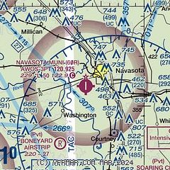
| Sectional chart |
|---|
|
| Airport distance calculator |
|---|
|
|
| Sunrise and sunset |
|---|
|
Times for 23-May-2026
| | Local
(UTC-5) | | Zulu
(UTC) |
|---|
| Morning civil twilight | | 06:00 | | 11:00 |
| Sunrise | | 06:27 | | 11:27 |
| Sunset | | 20:15 | | 01:15 |
| Evening civil twilight | | 20:42 | | 01:42 |
|
| Current date and time |
|---|
| Zulu (UTC) | 23-May-2026 18:07:20 |
|---|
| Local (UTC-5) | 23-May-2026 13:07:20 |
|---|
|
| METAR |
|---|
K11R
16nm SW | 231755Z AUTO 00000KT 10SM BKN022 26/20 A2994 RMK AO2 LTG DSNT E AND SE T02620204 10266 20222
|
KCLL
18nm NW | 231753Z 18006KT 10SM CLR 28/21 A2992 RMK AO2 SLP127 T02830206 10289 20200 58004
|
KCFD
24nm NW | 231755Z AUTO 20004KT 10SM CLR 29/20 A2995 RMK AO2 LTG DSNT SE T02880203 10291 20193
|
KRWV
32nm W | 231755Z AUTO 16009KT 10SM BKN028 BKN037 29/22 A2994 RMK AO2 LTG DSNT E
|
|
| TAF |
|---|
KCLL
18nm NW | 231739Z 2318/2418 15005KT P6SM SCT050 FM232100 17007KT 6SM -SHRA BR VCTS BKN035CB OVC050 TEMPO 2322/2401 4SM -TSRA BR BKN025CB BKN050 FM240100 09005KT P6SM VCSH SCT025 OVC100 FM240600 VRB04KT P6SM BKN025 FM241300 VRB03KT 6SM BR BKN009 FM241500 02006KT P6SM SCT015 SCT250
|
|
| NOTAMs |
|---|
NOTAMs are issued by the DoD/FAA and will open in a separate window not controlled by AirNav.
|
|

