FAA INFORMATION EFFECTIVE 09 JULY 2026
Location
| FAA Identifier: | BAM |
| Lat/Long: | 40-35-56.6000N 116-52-27.6000W
40-35.943333N 116-52.460000W
40.5990556,-116.8743333
(estimated) |
| Elevation: | 4536.1 ft. / 1382.6 m (surveyed) |
| Variation: | 13E (2020) |
| From city: | 3 miles SE of BATTLE MOUNTAIN, NV |
| Time zone: | UTC -7 (UTC -8 during Standard Time) |
| Zip code: | 89820 |
Airport Operations
| Airport use: | Open to the public |
| Activation date: | 02/1944 |
| Control tower: | no |
| ARTCC: | SALT LAKE CITY CENTER |
| FSS: | RENO FLIGHT SERVICE STATION |
| NOTAMs facility: | RNO (NOTAM-D service available) |
| Attendance: | OCT-MAY 0700-1700, JUN-SEP 0700-1800
AFT HRS CALL (775) 635-2245. |
| Wind indicator: | lighted |
| Segmented circle: | yes |
| Lights: | ACTVT REIL RWY 04 & 22; PAPI RWY 04 & 22; MIRL RWY 04/22 & 13/31; PERI LGTS H1 - CTAF. |
| Beacon: | white-green (lighted land airport)
Operates sunset to sunrise. |
| Taxiway lights: | EDGE REFLECTORS ON TWYS AND RAMP. |
Airport Communications
| CTAF/UNICOM: | 122.8 |
| WX AWOS-3: | 119.45 (775-635-8419) |
- APCH/DEP CTL SVC PRVDD BY SALT LAKE ARTCC (ZLC) ON FREQS 132.25/338.35 (BATTLE MOUNTAIN RCAG).
- COMMUNICATIONS PRVDD BY RENO RADIO ON FREQ 122.4 (BATTLE MOUNTAIN RCO).
Nearby radio navigation aids
| VOR radial/distance | | VOR name | | Freq | | Var |
|---|
| BAMr038/2.8 | | BATTLE MOUNTAIN VORTAC | | 112.20 | | 13E |
Airport Services
| Fuel available: | 100LL JET-A |
| Parking: | hangars and tiedowns |
| Airframe service: | MAJOR |
| Powerplant service: | MAJOR |
| Bottled oxygen: | NONE |
| Bulk oxygen: | NONE |
Runway Information
Runway 4/22
| Dimensions: | 7300 x 150 ft. / 2225 x 46 m |
| Surface: | asphalt, in good condition |
| Weight bearing capacity: | | Single wheel: | 30.0 | | Double wheel: | 125.0 |
|
| Runway edge lights: | medium intensity |
| Runway edge markings: | RWY NRS FADED. |
| RUNWAY 4 | | RUNWAY 22 |
| Latitude: | 40-35.630198N | | 40-36.417347N |
| Longitude: | 116-53.098453W | | 116-51.906857W |
| Elevation: | 4535.5 ft. | | 4531.3 ft. |
| Traffic pattern: | left | | left |
| Runway heading: | 036 magnetic, 049 true | | 216 magnetic, 229 true |
| Markings: | nonprecision, in fair condition | | nonprecision, in fair condition |
| Visual slope indicator: | 4-light PAPI on right (3.20 degrees glide path) | | 4-light PAPI on left (3.00 degrees glide path) |
| Runway end identifier lights: | yes | | yes |
| Touchdown point: | yes, no lights | | yes, no lights |
Runway 13/31
| Dimensions: | 7299 x 100 ft. / 2225 x 30 m |
| Surface: | asphalt, in poor condition
PCI 54 L & T ALLIGATOR PATCHING, BONE CRACKING, WEEDS GROWING THRU CRACKS. |
| Weight bearing capacity: | | Single wheel: | 30.0 | | Double wheel: | 104.0 |
|
| Runway edge lights: | medium intensity |
| Runway edge markings: | THR MARKINGS FADED. |
| RUNWAY 13 | | RUNWAY 31 |
| Latitude: | 40-36.316150N | | 40-35.407918N |
| Longitude: | 116-52.934625W | | 116-51.902182W |
| Elevation: | 4535.9 ft. | | 4535.4 ft. |
| Traffic pattern: | left | | left |
| Runway heading: | 126 magnetic, 139 true | | 306 magnetic, 319 true |
| Markings: | basic, in poor condition | | basic, in poor condition |
| Runway end identifier lights: | no | | no |
| Touchdown point: | yes, no lights | | yes, no lights |
Helipad H1
| Dimensions: | 60 x 60 ft. / 18 x 18 m |
| Surface: | concrete, in good condition |
| Runway edge lights: | PERI |
| Runway edge markings: | BLACK OUTLINE IS PARTIALLY VSB, W INTERIOR GONE. |
| Latitude: | 40-36.398333N | | |
| Longitude: | 116-52.373833W | | |
| Elevation: | 4528.0 ft. | | |
| Traffic pattern: | left | | left |
| Markings: | basic, in poor condition | | |
Helipad H2
| Dimensions: | 60 x 60 ft. / 18 x 18 m |
| Surface: | concrete, in good condition |
| Runway edge lights: | PERI |
| Runway edge markings: | BLACK OUTLINE PARTIALLY VSB. W INTERIOR GONE. |
| Latitude: | 40-36.395833N | | |
| Longitude: | 116-52.399667W | | |
| Elevation: | 4528.0 ft. | | |
| Traffic pattern: | left | | left |
| Markings: | basic, in poor condition | | |
Airport Ownership and Management from official FAA records
| Ownership: | Publicly-owned |
| Owner: | LANDER COUNTY
50 STATE ROUTE 305
BATTLE MOUNTAIN, NV 89820
Phone 775-635-2885 |
| Manager: | BERT RAMOS
50 STATE ROUTE 305
BATTLE MOUNTAIN, NV 89820
Phone 775-455-6860 |
Additional Remarks
| A39-13/31 | PCR VALUE: 63/F/C/W/T |
| A39-04/22 | PCR VALUE: 63/F/C/W/T |
| - | FOR CD IF UNA TO CTC ON FSS FREQ, CTC SALT LAKE ARTCC AT 801-320-2568. |
Instrument Procedures
NOTE: All procedures below are presented as PDF files. If you need a reader for these files, you should download the free Adobe Reader.NOT FOR NAVIGATION. Please procure official charts for flight.
FAA instrument procedures published for use from 09 July 2026 at 0901Z to 06 August 2026 at 0900Z.
IAPs - Instrument Approach Procedures |
|---|
| RNAV (GPS) RWY 04 | |
download (335KB) |
| RNAV (GPS) RWY 22 | |
download (255KB) |
| VOR RWY 04 | |
download (308KB) |
| NOTE: Special Alternate Minimums apply | |
download (143KB) |
| NOTE: Special Take-Off Minimums/Departure Procedures apply | |
download (416KB) |
Other nearby airports with instrument procedures:
KWMC - Winnemucca Municipal Airport (46 nm NW)
KEKO - Elko Regional Airport (51 nm E)
05U - Eureka Airport (72 nm SE)
KLOL - Derby Field Airport (84 nm W)
10U - Owyhee Airport (87 nm N)
|
|

Road maps at:
MapQuest
Bing
Google
| Aerial photo |
|---|
WARNING: Photo may not be current or correct
 Photo taken 08-Oct-2006
Do you have a better or more recent aerial photo of Battle Mountain Airport that you would like to share? If so, please send us your photo.
|
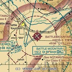
| Sectional chart |
|---|
|
| Airport distance calculator |
|---|
|
|
| Sunrise and sunset |
|---|
|
Times for 28-Jul-2026
| | Local
(UTC-7) | | Zulu
(UTC) |
|---|
| Morning civil twilight | | 05:11 | | 12:11 |
| Sunrise | | 05:42 | | 12:42 |
| Sunset | | 20:06 | | 03:06 |
| Evening civil twilight | | 20:37 | | 03:37 |
|
| Current date and time |
|---|
| Zulu (UTC) | 28-Jul-2026 19:34:53 |
|---|
| Local (UTC-7) | 28-Jul-2026 12:34:53 |
|---|
|
| METAR |
|---|
KBAM
3nm SW | 281915Z AUTO 32004KT 10SM CLR 35/M06 A3003 RMK AO1
|
|
| TAF |
|---|
KBAM
3nm SW | 281720Z 2818/2918 VRB03KT P6SM SKC FM282100 31009KT P6SM SKC FM290600 VRB05KT P6SM SKC
|
|
| NOTAMs |
|---|
NOTAMs are issued by the DoD/FAA and will open in a separate window not controlled by AirNav.
|
|

