FAA INFORMATION EFFECTIVE 22 JANUARY 2026
Location
| FAA Identifier: | BSF |
| Lat/Long: | 19-45-36.0482N 155-33-13.5583W
19-45.600803N 155-33.225972W
19.7600134,-155.5537662
(estimated) |
| Elevation: | 6190.2 ft. / 1886.8 m (surveyed) |
| Variation: | 10E (2000) |
| From city: | 1 mile W of CAMP POHAKULOA, HI |
| Time zone: | UTC -10 (year round; does not observe DST) |
| Zip code: | 96738 |
Airport Operations
| Airport use: | Private use. Permission required prior to landing |
| Activation date: | 04/1960 |
| Control tower: | yes |
| ARTCC: | HONOLULU CONTROL FACILITY CENTER |
| FSS: | HONOLULU FLIGHT SERVICE STATION |
| NOTAMs facility: | HNL (NOTAM-D service available) |
| Attendance: | MON-FRI 0700-1500, EXC HOL
PHONE HONOLULU C808-433-1810 EXTN 461. |
| Pattern altitude: | TPA 6900' MSL HEL & 7700' MSL ALL OTHER ACFT. |
| Wind indicator: | yes |
| Segmented circle: | no |
| Lights: | ACTVT MIRL RY 09/27 AND PAPI RY 09 - 121.7. |
Airport Communications
| CTAF: | 119.275 |
| ATIS: | 124.7 293.225 |
| BRADSHAW GROUND: | 121.7 226.675 [1715-0100Z MON-FRI] |
| BRADSHAW TOWER: | 119.275 236.6 41.5FM [1715-0100Z MON-FRI] |
| EMERG: | 243.0 |
| FLT FLW: | 239.5 ;LIGHTNING AIC |
| PMSV METRO: | 122.75 |
| RANGE CTL: | 141.05 38.3FM |
| VFR ADZY: | 121.65 ;PMSV |
| WX AWOS-3PT at MUE (16 nm NW): | 120.0 (808-887-8127) |
- APCH/DEP SVC PRVDD BY HONOLULU CONTROL FACILITY (ZHN) ON FREQS 118.45 (HALEAKALA RCAG) /278.3 (MOUNT HALEAKALA RCAG).
- 17 OWS WX TF 808-449-8335 .
- PMSV UNREADABLE BLW 6190' AND VCNTY MT. SVC IS AVBL ONLY WHEN AFLD IS OPR. HICKAM METRO - 346.6, REMOTE BRIEF AVBL.
- RANGE - OPR H24. 38.3 125.2.
- PTA RANGE ATIS 132.5/244.250.
Nearby radio navigation aids
| VOR radial/distance | | VOR name | | Freq | | Var |
|---|
| MUEr144/15.7 | | KAMUELA VOR/DME | | 113.30 | | 11E |
| KOAr074/27.9 | | KONA VORTAC | | 112.10 | | 11E |
| ITOr263/30.7 | | HILO VORTAC | | 116.90 | | 11E |
| UPPr137/31.1 | | UPOLU POINT VORTAC | | 112.30 | | 11E |
| NDB name | | Hdg/Dist | | Freq | | Var | | ID |
|---|
| PAHOA | | 281/35.4 | | 332 | | 11E | | POA | .--. --- .- |
Airport Services
Runway Information
Runway 9/27
| Dimensions: | 3696 x 100 ft. / 1127 x 30 m |
| Surface: | asphalt |
| Weight bearing capacity: | |
| Runway edge lights: | medium intensity |
| RUNWAY 9 | | RUNWAY 27 |
| Latitude: | 19-45.658167N | | 19-45.543667N |
| Longitude: | 155-33.542500W | | 155-32.909500W |
| Elevation: | 6081.2 ft. | | 6190.2 ft. |
| Traffic pattern: | right | | right |
| Runway heading: | 091 magnetic, 101 true | | 271 magnetic, 281 true |
| Markings: | nonprecision, in good condition | | nonprecision, in good condition |
| Visual slope indicator: | 4-light PAPI on left (3.00 degrees glide path) | | |
| Runway end identifier lights: | no | | no |
| Touchdown point: | yes, no lights | | yes, no lights |
| Obstructions: | none | | terrain, 9999 ft. from runway, 20:1 slope to clear |
Airport Ownership and Management from official FAA records
| Ownership: | U.S. Army |
| Owner: | USAR HAW
C/O POSTMASTER
SAN FRANCISCO, CA 96557 |
| Manager: | COMMANDING OFFICER
POHAKULOA TRNG AREA
APO SAN FRANCISCO, CA 96556
Phone 808-961-6232
ERNEST L. JACKSON, AIRFIELD MANAGER (808) 969-2461. |
Additional Remarks
| A93 | 42 HEL PARKING STALLS ON BOTH SIDES OF RWY E OF TWY. |
| - | TRML, PLANES & MRKD TWR ON ARPT. |
| - | LMT CRASH/FIRE FACILITY FOR SKEDD FLTS DURING AFLD OPERG HOURS.. |
| - | F/W ACFT TAKEOFF AND LANDING NOT AUTHORIZED WHEN ATCT CLSD. |
| - | FUEL- JAA/F24 - 24 HR PPR, FUEL ONLY TRAN ACFT, MIL EXER ACFT UNIT SHALL PROVIDE FUEL . |
| - | FLT WITHIN 4900 FT OR DRCT OVFLT BLO 9000 FT OVER MAUNA KEA STATE PARK LCTD 8200 FT ESE OF AFLD IS PROH. |
| - | 500 X 90 OVRN BOTH ENDS RWY 9-27. |
| - | HI FOD POTENTIAL IN ALL AREAS OF AFLD. |
| - | FLT WITHIN 3/4 NM OR OVFLT BLO 7000 FT OF WAIKII RANCH 7.9 NM NW PROH. |
| - | OVFLT OR LNDG AT KAWAIHAE DOCKS IS PROH FOR ALL MIL ACFT. |
| - | WHEN ATCT CLSD, ACFT REMAIN N OF SADDLE ROAD AND ESTAB TWO-WAY COM WITH RANGE CON PRIOR TO ENTRY R-3103. |
| - | OVERUN AVBL FOR TKOFF RY 27 END. |
| - | CAUTION: HI WINDS AND LO LEVEL WIND SHEAR MAY EXIST |
| - | MISC: BASE WX STATION OPEN MON-FRI 1700-0100Z EXC HOL. WX OBSERVERS VIEW OBSTRUCTED BY BUILDINGS S-SW. REMOTE WX BRIEFINGS AVBL FR 17 OWS WX SQ 24HRS AT DSN/COMM 449-8333, 2HR PRIOR NTC RQR FOR BRIEF. |
| - | EXTSV HOP & F/W OPR. DUTY HRS ARE FLEX'D DURING EXER. 16/5 DUTY HRS FOR TWR OPNS & WX CHECK NOTAMS FOR CURRENT OPN HRS. |
| - | FUEL - J8 (MIL): 24 HR PPR, 1730-0000Z MON-FRI EXC HOL, C808-969-2461. |
| - | ARPT IS VFR FLD FOR MIL TRAINING. |
| - | FOR CD WHEN ATCT CLSD, CTC HONOLULU CONTROL FACILITY AT 808-840-6262. |
| - | CAUTION: WILDLIFE HAZ MULT UNGALATES (SHEEP/GOATS) MAY BE ON OR NEAR RWY. |
| - | RSTD - PPR FOR FULL STOP LDG, PKG AND FOR NON-TENANT ACFT. 72 HR PPR FOR HAZ CARGO OPNS, F/W OPNS, & CODE MOVEMENT, 24 HR PPR FOR ALL TRAN ACFT; OVFT OF AMMO SUPPLY PT LCTD 3300 FT S OF AFLD IS PROH. |
| - | NO ACFT WITH SKIDS ON FIXED WING RAMP. |
| - | CAUTION: 7 FT LIP AT W END OF OVRN. 75 FT OF LAVA ROCK EACH SIDE OF RWY FOR DUST CTL. EXTV DUST HAZARD TO F/W ACFT ON E & W COPTER PKG RAMPS. |
| - | 2.9% UP SLOPE W TO E. EXTSV COPTER TFC VCNTY OF AFLD. TERRAIN RISES RAPIDLY N OF AFLD TO 13796' MSL. |
| - | TFC PAT FOR ROTOR WING NORTH OF RWY 09/27. F/W AS DIRECTED BY ATC. |
Instrument Procedures
NOTE: All procedures below are presented as PDF files. If you need a reader for these files, you should download the free Adobe Reader.NOT FOR NAVIGATION. Please procure official charts for flight.
FAA instrument procedures published for use from 22 January 2026 at 0901Z to 19 February 2026 at 0900z.
IAPs - Instrument Approach Procedures |
|---|
| RNAV (GPS) RWY 09 | |
download (126KB) |
| NOTE: Special Take-Off Minimums/Departure Procedures apply | |
download (197KB) |
Other nearby airports with instrument procedures:
PHMU - Waimea-Kohala Airport (16 nm NW)
PHKO - Ellison Onizuka Kona International Airport at Keahole (28 nm W)
PHTO - Hilo International Airport (29 nm E)
PHHN - Hana Airport (67 nm NW)
PHOG - Kahului Airport (84 nm NW)
|
|

Road maps at:
MapQuest
Bing
Google
| Aerial photo |
|---|
WARNING: Photo may not be current or correct
 Photo by Charles K. Morris, South Ramp Solutions LLC
Photo taken 15-Jan-2008
from a Cessna 182
Photo by Charles K. Morris, South Ramp Solutions LLC
Photo taken 15-Jan-2008
from a Cessna 182
Do you have a better or more recent aerial photo of Bradshaw Army Airfield that you would like to share? If so, please send us your photo.
|
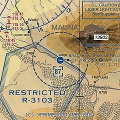
| Sectional chart |
|---|
|
| Airport distance calculator |
|---|
|
|
| Sunrise and sunset |
|---|
|
Times for 22-Jan-2026
| | Local
(UTC-10) | | Zulu
(UTC) |
|---|
| Morning civil twilight | | 06:37 | | 16:37 |
| Sunrise | | 07:01 | | 17:01 |
| Sunset | | 18:07 | | 04:07 |
| Evening civil twilight | | 18:31 | | 04:31 |
|
| Current date and time |
|---|
| Zulu (UTC) | 22-Jan-2026 23:09:51 |
|---|
| Local (UTC-10) | 22-Jan-2026 13:09:51 |
|---|
|
| METAR |
|---|
| PHSF | 222255Z AUTO 27015KT 10SM FEW150 FEW170 FEW250 SCT310 17/10 A3030 RMK AO2 SLP160 T01690100 $
|
|
| NOTAMs |
|---|
NOTAMs are issued by the DoD/FAA and will open in a separate window not controlled by AirNav.
|
|

