FAA INFORMATION EFFECTIVE 10 JULY 2025
Location
| FAA Identifier: | BYY |
| Lat/Long: | 28-58-23.6880N 095-51-48.4270W
28-58.394800N 095-51.807117W
28.9732467,-95.8634519
(estimated) |
| Elevation: | 44.9 ft. / 13.7 m (surveyed) |
| Variation: | 03E (2020) |
| From city: | 5 miles E of BAY CITY, TX |
| Time zone: | UTC -5 (UTC -6 during Standard Time) |
| Zip code: | 77414 |
Airport Operations
| Airport use: | Open to the public |
| Control tower: | no |
| ARTCC: | HOUSTON CENTER |
| FSS: | MONTGOMERY COUNTY FLIGHT SERVICE STATION |
| NOTAMs facility: | BYY (NOTAM-D service available) |
| Attendance: | MON-FRI 0800-1700
ARPT UNATNDD HOLS. |
| Wind indicator: | lighted |
| Segmented circle: | yes |
| Lights: | MIRL RWY 13/31 PRESET LOW INTST SS-SR; TO INCR INTST AND ACTVT REIL RWY 13 - CTAF. PAPI RWY 13 OPRS CONSLY. |
| Beacon: | white-green (lighted land airport)
Operates sunset to sunrise. |
Airport Communications
| CTAF/UNICOM: | 122.8 |
| WX AWOS-3PT: | 118.075 (979-323-1801) |
| BLTWY RNAV DP: | 128.6 |
| CESAN STAR: | 121.3 |
| LURIC RNAV DP: | 128.6 |
| MMALT RNAV DP: | 128.6 |
| STRYA RNAV DP: | 128.6 |
| STYCK RNAV DP: | 128.6 |
| WAPPL STAR: | 120.05 |
| WYLSN RNAV DP: | 128.6 |
- APCH/DEP CTL SVC PRVDD BY HOUSTON ARTCC (ZHU) ON FREQS 128.6/360.8 (PALACIOS RCAG).
Nearby radio navigation aids
| VOR radial/distance | | VOR name | | Freq | | Var |
|---|
| PSXr054/26.4 | | PALACIOS VORTAC | | 117.30 | | 08E |
Airport Services
| Fuel available: | 100LL JET-A
100LL:24 HR SELF-SERVICE FUEL. |
| Parking: | hangars and tiedowns |
Runway Information
Runway 13/31
| Dimensions: | 5107 x 75 ft. / 1557 x 23 m |
| Surface: | asphalt, in good condition |
| Weight bearing capacity: | | Single wheel: | 30.0 | | Double wheel: | 51.0 | | Double tandem: | 82.0 |
|
| Runway edge lights: | medium intensity |
| RUNWAY 13 | | RUNWAY 31 |
| Latitude: | 28-58.685163N | | 28-58.104410N |
| Longitude: | 095-52.154343W | | 095-51.459925W |
| Elevation: | 44.4 ft. | | 39.9 ft. |
| Traffic pattern: | left | | left |
| Runway heading: | 131 magnetic, 134 true | | 311 magnetic, 314 true |
| Markings: | nonprecision, in good condition | | nonprecision, in good condition |
| Visual slope indicator: | 2-light PAPI on left (3.00 degrees glide path) | | |
| Runway end identifier lights: | yes | | yes
OPRS ON PHOTOCELL. |
| Touchdown point: | yes, no lights | | yes, no lights |
| Obstructions: | 36 ft. tree, 1053 ft. from runway, 287 ft. right of centerline, 23:1 slope to clear | | 25 ft. pole, 1170 ft. from runway, 300 ft. right of centerline, 38:1 slope to clear |
Airport Ownership and Management from official FAA records
| Ownership: | Publicly-owned |
| Owner: | CITY OF BAY CITY
CITY HALL 1901 5TH ST
BAY CITY, TX 77414
Phone 979-245-5311 |
| Manager: | JAMES MASON
3598 NORTH FM 2540
BAY CITY, TX 77414
Phone 979-244-5037 |
Additional Remarks
| - | TWY REFLECTORS ON ALL TWYS. |
| - | AFTR HRS ATTENDANT CALL AMGR, FEE $55/HR, TWO HR MIN. |
| - | FOR CD CTC HOUSTON ARTCC AT 281-230-5622. |
Instrument Procedures
NOTE: All procedures below are presented as PDF files. If you need a reader for these files, you should download the free Adobe Reader.NOT FOR NAVIGATION. Please procure official charts for flight.
FAA instrument procedures published for use from 10 July 2025 at 0901Z to 07 August 2025 at 0900z.
STARs - Standard Terminal Arrivals |
|---|
| CESAN FOUR (RNAV) | |
2 pages:
[1] [2] (403KB) |
| WAPPL SEVEN (RNAV) **NEW** | |
2 pages:
[1] [2] (404KB) |
| WAPPL SEVEN (RNAV), CONT.2 **NEW** | |
download (283KB) |
IAPs - Instrument Approach Procedures |
|---|
| RNAV (GPS) RWY 13 | |
download (228KB) |
| RNAV (GPS) RWY 31 | |
download (219KB) |
| VOR-A | |
download (181KB) |
| NOTE: Special Alternate Minimums apply | |
download (44KB) |
Departure Procedures |
|---|
| BLTWY SEVEN (RNAV) | |
download (151KB) |
| INDIE EIGHT (RNAV) | |
download (177KB) |
| LURIC EIGHT (RNAV) | |
download (200KB) |
| MMALT SEVEN (RNAV) | |
download (202KB) |
| STRYA EIGHT (RNAV) | |
download (189KB) |
| STYCK EIGHT (RNAV) | |
download (176KB) |
| WYLSN EIGHT (RNAV) | |
download (159KB) |
| NOTE: Special Take-Off Minimums/Departure Procedures apply | |
download (109KB) |
Other nearby airports with instrument procedures:
KLBX - Texas Gulf Coast Regional Airport (23 nm E)
KARM - Wharton Regional Airport (23 nm NW)
KPSX - Palacios Municipal Airport (25 nm SW)
26R - Jackson County Airport (38 nm W)
KAXH - Houston Southwest Airport (38 nm NE)
|
|

Road maps at:
MapQuest
Bing
Google
| Aerial photo |
|---|
WARNING: Photo may not be current or correct
 Photo by Danny Schnautz
Photo taken 07-Nov-2020
looking west from 2000'
Photo by Danny Schnautz
Photo taken 07-Nov-2020
looking west from 2000'
Do you have a better or more recent aerial photo of Bay City Regional Airport that you would like to share? If so, please send us your photo.
|
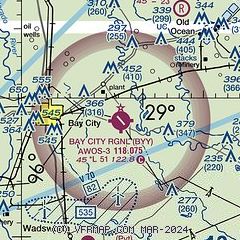
| Sectional chart |
|---|
|
| Airport distance calculator |
|---|
|
|
| Sunrise and sunset |
|---|
|
Times for 30-Jul-2025
| | Local
(UTC-5) | | Zulu
(UTC) |
|---|
| Morning civil twilight | | 06:18 | | 11:18 |
| Sunrise | | 06:44 | | 11:44 |
| Sunset | | 20:16 | | 01:16 |
| Evening civil twilight | | 20:41 | | 01:41 |
|
| Current date and time |
|---|
| Zulu (UTC) | 30-Jul-2025 21:24:01 |
|---|
| Local (UTC-5) | 30-Jul-2025 16:24:01 |
|---|
|
| METAR |
|---|
| KBYY | 302055Z AUTO 00000KT 10SM CLR 34/23 A2995 RMK AO2 T03390227
|
|
| TAF |
|---|
KLBX
23nm NE | 301729Z 3018/3118 29004KT P6SM FEW035 BKN250 FM302100 19007KT P6SM FEW040 BKN250 FM310300 23003KT P6SM BKN250 FM311200 26005KT P6SM SCT070 BKN120 OVC250 PROB30 3114/3118 -SHRA
|
|
| NOTAMs |
|---|
NOTAMs are issued by the DoD/FAA and will open in a separate window not controlled by AirNav.
|
|


