FAA INFORMATION EFFECTIVE 15 MAY 2025
Location
| FAA Identifier: | FWC |
| Lat/Long: | 38-22-43.0790N 088-24-45.5480W
38-22.717983N 088-24.759133W
38.3786331,-88.4126522
(estimated) |
| Elevation: | 434.4 ft. / 132.4 m (surveyed) |
| Variation: | 01W (2000) |
| From city: | 2 miles W of FAIRFIELD, IL |
| Time zone: | UTC -5 (UTC -6 during Standard Time) |
| Zip code: | 62837 |
Airport Operations
| Airport use: | Open to the public |
| Activation date: | 04/1954 |
| Control tower: | no |
| ARTCC: | KANSAS CITY CENTER |
| FSS: | SAINT LOUIS FLIGHT SERVICE STATION |
| NOTAMs facility: | FWC (NOTAM-D service available) |
| Attendance: | 0800-1600
FOR ATTENDANT OTR HRS CALL NUMBER LOCATED AT FBO ENTRANCE. |
| Wind indicator: | lighted |
| Segmented circle: | no |
| Lights: | MIRL RY 18/36 PRESET ON LOW INTST; TO INCR INTST & ACTVT MIRL RY 09/27; REIL RY 09 - 123.05. |
| Beacon: | white-green (lighted land airport)
Operates sunset to sunrise. |
Airport Communications
| CTAF/UNICOM: | 123.05 |
| WX AWOS-3PT: | 119.425 (618-847-4709) |
| WX AWOS-3 at FOA (17 nm N): | 120.175 (618-662-8355) |
- APCH/DEP SVC PRVDD BY KANSAS CITY ARTCC ON FREQS 127.7/351.825 (MOUNT VERNON RCAG).
Nearby radio navigation aids
| VOR radial/distance | | VOR name | | Freq | | Var |
|---|
| BIBr171/32.7 | | BIBLE GROVE VORTAC | | 109.00 | | 03E |
| ENLr090/35.2 | | CENTRALIA VORTAC | | 115.00 | | 04E |
| NDB name | | Hdg/Dist | | Freq | | Var | | ID |
|---|
| WAYNE COUNTY | | at field | | 257 | | 01W | | FWC | ..-. .-- -.-. |
| OLNEY | | 212/23.3 | | 272 | | 03W | | OLY | --- .-.. -.-- |
Airport Services
| Fuel available: | 100LL JET-A |
| Parking: | tiedowns |
| Bottled oxygen: | NONE |
| Bulk oxygen: | NONE |
Runway Information
Runway 9/27
| Dimensions: | 4000 x 75 ft. / 1219 x 23 m |
| Surface: | asphalt, in good condition |
| Weight bearing capacity: | |
| Runway edge lights: | medium intensity |
| RUNWAY 9 | | RUNWAY 27 |
| Latitude: | 38-22.679040N | | 38-22.674422N |
| Longitude: | 088-25.331613W | | 088-24.494663W |
| Elevation: | 434.4 ft. | | 412.8 ft. |
| Traffic pattern: | left | | left |
| Runway heading: | 091 magnetic, 090 true | | 271 magnetic, 270 true |
| Markings: | nonprecision, in fair condition | | nonprecision, in fair condition |
| Visual slope indicator: | pulsating/steady burning VASI on left (3.00 degrees glide path) | | pulsating/steady burning VASI on left (3.00 degrees glide path) |
| Runway end identifier lights: | yes | | |
| Touchdown point: | yes, no lights | | yes, no lights |
Runway 18/36
| Dimensions: | 1999 x 60 ft. / 609 x 18 m |
| Surface: | asphalt, in good condition |
| Weight bearing capacity: | |
| Runway edge lights: | medium intensity |
| Runway edge markings: | RWY 36 MARKING FADED. |
| RUNWAY 18 | | RUNWAY 36 |
| Latitude: | 38-22.964540N | | 38-22.635175N |
| Longitude: | 088-24.448745W | | 088-24.453363W |
| Elevation: | 415.6 ft. | | 413.2 ft. |
| Traffic pattern: | left | | left |
| Runway heading: | 182 magnetic, 181 true | | 002 magnetic, 001 true |
| Markings: | basic, in poor condition | | basic, in poor condition |
| Runway end identifier lights: | no | | no |
| Touchdown point: | yes, no lights | | yes, no lights |
| Obstructions: | 20 ft. trees, 520 ft. from runway, 16:1 slope to clear | | 14 ft. road, 323 ft. from runway, 136 ft. right of centerline, 8:1 slope to clear
18/36 APPROACH SLOPE IS 23:1 TO RUNWAY 36 END. |
Airport Ownership and Management from official FAA records
| Ownership: | Publicly-owned |
| Owner: | CITY OF FAIRFIELD
CITY HALL,109 NE 2ND ST
FAIRFIELD, IL 62837
Phone 618-842-3871 |
| Manager: | TRAVIS WILLIAMS
CITY HALL 109 NE 2ND ST
FAIRFIELD, IL 62837
Phone 618-842-9587 |
Additional Remarks
| - | FOR CD CTC KANSAS CITY ARTCC AT 913-254-8508. |
Instrument Procedures
NOTE: All procedures below are presented as PDF files. If you need a reader for these files, you should download the free Adobe Reader.NOT FOR NAVIGATION. Please procure official charts for flight.
FAA instrument procedures published for use from 15 May 2025 at 0901Z to 13 June 2025 at 0900z.
IAPs - Instrument Approach Procedures |
|---|
| RNAV (GPS) RWY 09 | |
download (186KB) |
| NDB RWY 09 | |
download (172KB) |
| NOTE: Special Alternate Minimums apply | |
download (161KB) |
| NOTE: Special Take-Off Minimums/Departure Procedures apply | |
download (201KB) |
Other nearby airports with instrument procedures:
KFOA - Flora Municipal Airport (17 nm N)
KMVN - Mount Vernon Airport (21 nm W)
KCUL - Carmi Municipal Airport (22 nm SE)
KOLY - Olney-Noble Airport (23 nm NE)
KSLO - Salem-Leckrone Airport (30 nm NW)
|
|

Road maps at:
MapQuest
Bing
Google
| Aerial photo |
|---|
WARNING: Photo may not be current or correct

Do you have a better or more recent aerial photo of Fairfield Municipal Airport that you would like to share? If so, please send us your photo.
|
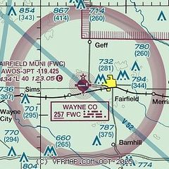
| Sectional chart |
|---|
|
| Airport distance calculator |
|---|
|
|
| Sunrise and sunset |
|---|
|
Times for 18-May-2025
| | Local
(UTC-5) | | Zulu
(UTC) |
|---|
| Morning civil twilight | | 05:11 | | 10:11 |
| Sunrise | | 05:41 | | 10:41 |
| Sunset | | 19:59 | | 00:59 |
| Evening civil twilight | | 20:29 | | 01:29 |
|
| Current date and time |
|---|
| Zulu (UTC) | 18-May-2025 22:47:14 |
|---|
| Local (UTC-5) | 18-May-2025 17:47:14 |
|---|
|
| METAR |
|---|
| KFWC | 182235Z AUTO 00000KT 10SM CLR 25/08 A2993 RMK AO2 T02470081
|
KFOA
17nm N | 182235Z AUTO 00000KT 10SM CLR 25/09 A2993 RMK AO2
|
|
| TAF |
|---|
KMVN
22nm W | 181720Z 1818/1918 VRB04KT P6SM SCT090 BKN150 TEMPO 1818/1822 BKN090 FM190000 VRB03KT P6SM BKN250 FM190500 VRB03KT 6SM -SHRA BKN030 PROB30 1909/1912 4SM -TSRA BR BKN020CB
|
|
| NOTAMs |
|---|
NOTAMs are issued by the DoD/FAA and will open in a separate window not controlled by AirNav.
|
|


